
Joshua Tree Map: Park Areas, Official Map, and Download
Joshua Tree National Park lies in the Southern California desert, about 133 miles east of Los Angeles and 50 miles east of Palm Springs. The park's official map is available as a free PDF on the NPS website and at each of the three entrance stations.
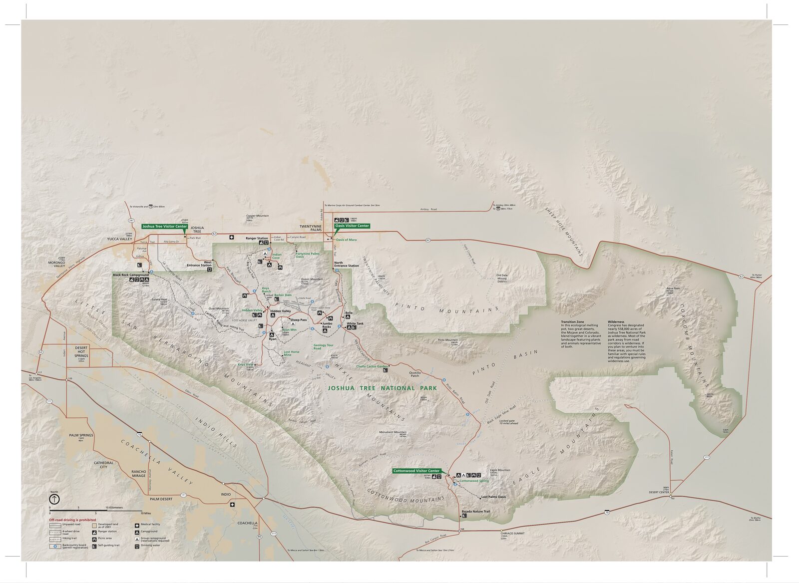
The official park map handed out at entrance stations, with roads, areas, visitor centers and services. View it here or download it for offline use.
Download the map (PDF) Public domain · National Park ServiceWhere Is Joshua Tree?
Joshua Tree National Park is in Southern California, spanning Riverside and San Bernardino counties. Its location is unusual: the park sits between two distinct deserts. In the northwest, the Mojave Desert rises to 5,900 feet and is home to the famous Joshua trees (Yucca brevifolia). In the southeast, the Colorado Desert drops to 1,970 feet. It's hotter there, with cholla and ocotillo dominating the landscape.
The gateway town on the west side is Yucca Valley, just a few miles from the West Entrance. Twentynine Palms sits next to the North Entrance.
Download the Official Joshua Tree Map (NPS Unigrid)
The NPS publishes what's known as a Unigrid map. It's a large folded paper map, with the park map on the front and natural and practical information on the back. You can pick one up for free at any of the three entrance stations or download the PDF from the official NPS website.
The map shows paved roads, unpaved roads, some of which are reserved for 4WD vehicles, campgrounds, day-use areas, and the main points of interest. We recommend carrying it even if you use GPS. Cell service is nonexistent across most of the park, and signals disappear quickly between rock formations.
Joshua Tree's Park Areas
The park covers about 1,240 square miles and naturally breaks down into three geographic areas.
Northwest Area (Mojave Desert)
This is the park's main tourist hub, with granite formations, Joshua tree forests, bouldering areas, and the busiest campgrounds, including Hidden Valley Campground and Jumbo Rocks Campground. You can get there through the West Entrance or the North Entrance at Twentynine Palms. This is where you'll find most of the visitors, especially in spring when the wildflowers are in bloom.
Central Area (Transition Zone)
The central area marks the gradual transition between the two deserts. Joshua trees become less common, and the landscape opens into broad plains of granite and sand. Park Boulevard crosses some of its most photographed stretches, with open views of the Little San Bernardino Mountains.
Southeast Area (Colorado Desert)
Lower, hotter, and more arid, this area is home to Cholla Cactus Garden and Cottonwood Oasis. You enter through the South Entrance. It's less visited than the northwest, offering a straightforward desert experience.
Park Entrances and Driving Across the Park
Joshua Tree has three main entrances.
The West Entrance leads directly onto Park Boulevard, the park's main road. The North Entrance, in Twentynine Palms, opens onto the Oasis Visitor Center and nearby campgrounds.
The South Entrance is the least busy of the three. You can reach it from Palm Springs or via I-10 from the east.
Park Boulevard connects the West Entrance to the North Entrance along 31 miles of entirely paved road. Driving all the way across takes about an hour without stopping. People say “without stopping,” but that's purely theoretical. The rock formations won't let curious drivers pass without hitting the brakes.
For directions from your starting point, see how to get to Joshua Tree.
Points of Interest and Viewpoints on the Map
Here are a few spots to mark on your map before you leave.
Skull Rock (northwest area): a granite formation sculpted by erosion, accessible from Park Boulevard via a 1.7-mile round-trip trail.
Cholla Cactus Garden (southeast area): a 0.25-mile loop through a dense stand of jumping cholla. A tip from experience: keep your hands in your pockets. The spines catch on clothing before you even notice.
Keys View (5,180 feet): the park's panoramic viewpoint, with views of the San Andreas Fault and, on a clear day, the Salton Sea.
Cottonwood Spring: a quiet oasis and the starting point for trails leading to Lost Palms Oasis.
For trail-by-trail details, see Joshua Tree hikes and the park's must-do activities.
Nearest Towns and Airports
For the West Entrance and North Entrance, Yucca Valley and Twentynine Palms are the closest gateway towns. You'll find all the essentials there, including gas stations, grocery stores, and restaurants.
Palm Springs (about 50 miles west) is the most comfortable base for a well-organized stay. Los Angeles is about 133 miles away, a two-and-a-half-hour drive.
Paper Hiking Maps and Trail Guides
The NPS Unigrid map is more than enough for a typical driving visit with a few trails. For longer outings or off-trail travel, a 1:50,000 topographic map is a real asset. Cartovia and specialty travel bookstores, including ITM and Librairie du Voyage, carry maps and trail guides dedicated to Joshua Tree and the surrounding desert.
The park's visitor centers, including the Oasis Visitor Center in Twentynine Palms and Cottonwood Visitor Center in the south, also sell maps and guides on-site.
Frequently Asked Questions
Is Joshua Tree worth visiting?
Joshua Tree is worth visiting if you appreciate desert landscapes. The park combines two distinct ecosystems, striking rock formations, and a night sky ranked among the darkest in California. To find out whether this park fits your itinerary, see our complete Joshua Tree guide.
Is there an entrance fee for Joshua Tree National Park?
Yes. Admission costs $30 per vehicle, $25 per motorcycle, and $15 per person entering on foot or by bicycle. The park-specific annual pass costs $55, so it pays for itself on your second visit. For entrance fees and annual passes, see the National Parks Fees & Passes page.
How much time do you need to visit Joshua Tree?
A half day is enough for a drive-through visit with two or three stops. One to two days let you cover the two main areas with a few trails. Three days open the door to longer hikes and backcountry camping. Joshua Tree itineraries offer plans based on how much time you have.
Do any celebrities live in Joshua Tree?
The small town of Joshua Tree, just north of the park, has attracted a community of artists and musicians since the 1990s. It remains residential and low-key. For tourist services, Yucca Valley and Twentynine Palms are much more convenient.