
Death Valley Map: Regions, Access Roads, and the Official Park Map
Death Valley National Park stretches across the California-Nevada border, about 124 miles northwest of Las Vegas. Covering 5,270 square miles, it's the largest national park in the contiguous United States. The map makes that clear right away: five distinct geographic regions, elevations ranging from 282 feet below sea level at Badwater Basin to 11,043 feet along the Panamint Range, and internal distances measured in hours, not minutes. The official NPS Unigrid map is available as a free download on the NPS website. You'll find the link and details in the section below.
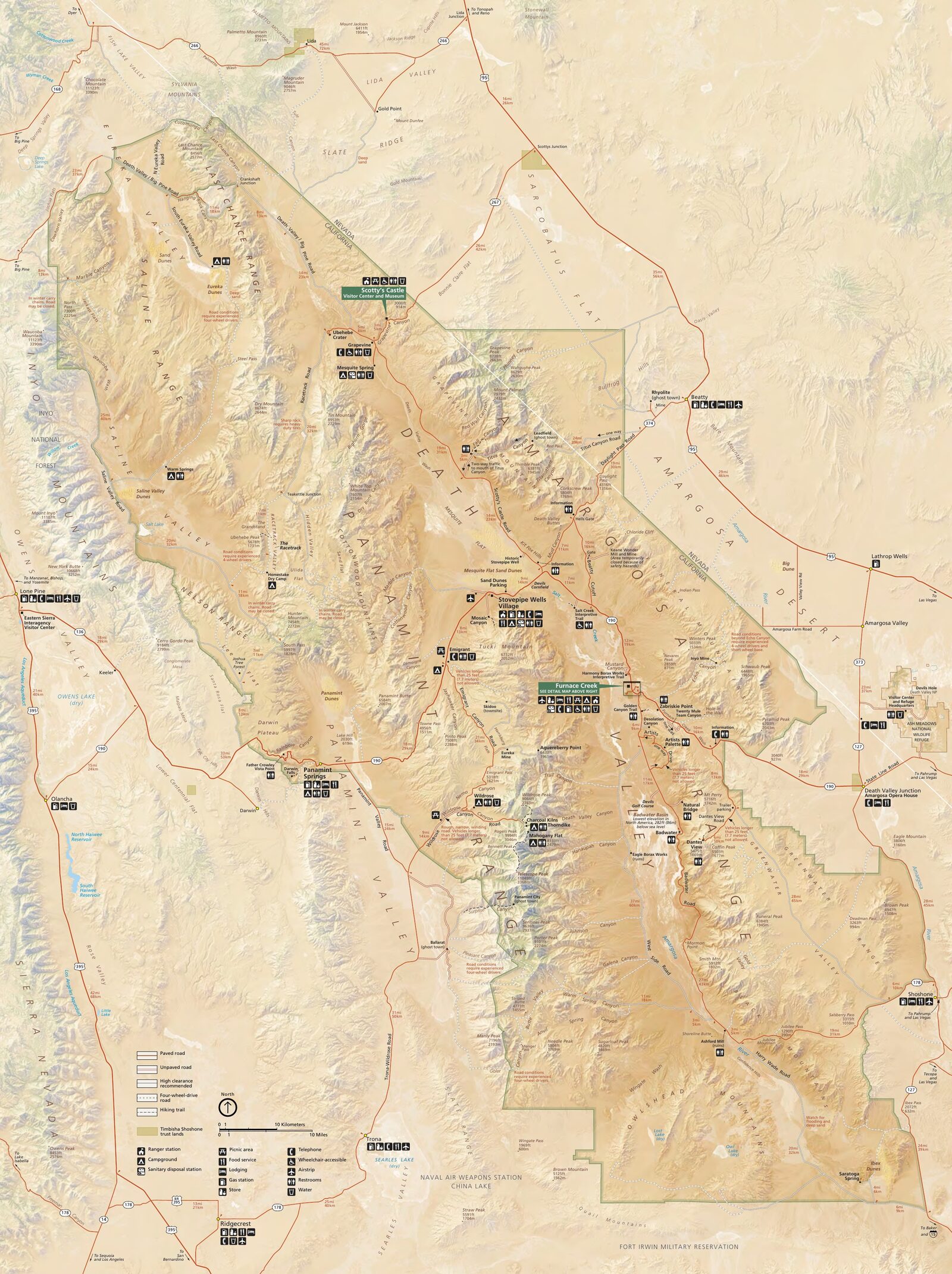
The official park map handed out at entrance stations, with roads, areas, visitor centers and services. View it here or download it for offline use.
Download the map (PDF) Public domain · National Park ServiceWhere Is Death Valley?
Death Valley National Park occupies the northeastern Mojave Desert, straddling eastern California and the southwestern tip of Nevada. The valley itself stretches roughly 140 miles from north to south, enclosed by two mountain ranges: the Panamint Range to the west and the Black Mountains to the east.
This position between two rocky walls explains the area's extreme climate. Hot air gets trapped here, and average annual precipitation on the valley floor stays below 2 inches. On a map of the United States, Death Valley lies about halfway between Los Angeles, 280 miles to the southwest, and Salt Lake City, 423 miles to the northeast. Most visitors include it in a longer road trip that also takes in Zion, Bryce Canyon, or the Grand Canyon. The Regions section provides this broader geographic context.
Download the Official Death Valley Map (NPS Unigrid)
The NPS publishes and updates its Unigrid map, available as a free PDF at nps.gov/deva in the “Maps” section. It's an unfolded A2 document: the map is on the front, with practical information on the back, including park rules, emergency numbers, campgrounds, and areas without cell service.
Here are the key points to know before you go:
- The Unigrid map covers paved roads, major unpaved roads, and service areas such as visitor centers, gas stations, and campgrounds.
- Rangers hand out paper copies at every park entrance.
- It isn't enough for secondary roads and remote areas such as Saline Valley and Eureka Dunes. See the “Hiking Maps” section at the end of the page.
- Cell service is almost nonexistent across most of the park, so print a copy before leaving the main road.
Death Valley's Regions
On the map, Death Valley breaks down into five sharply distinct geographic regions. The breakdown below is MECE: each region is separate, and together they cover the park without overlap.
Furnace Creek and the Lower Valley (Central Region)
Furnace Creek is the park's logistical hub, with the main visitor center, a hotel, gas station, general store, and campground. Every road converges here along Highway 190. Within a 19-mile radius of Furnace Creek, you'll find the most visited sites: Zabriskie Point, Artists Drive, Badwater Basin, Devils Golf Course, and Salt Creek. If you've only got one day, you'll stay in this region and won't feel like you're missing much.
Stovepipe Wells and the Sand Dunes (Northwestern Region)
About 28 miles west-northwest of Furnace Creek on Highway 190, Stovepipe Wells is the park's second supply base, with a motel, campground, general store, and fuel. Just east of town, Mesquite Flat Sand Dunes stretch for several miles. They're the only major dunes accessible by a standard car without taking an unpaved road. Walk the sand freely, without a marked route, but keep sight of your car from the dunes before you head farther away.
Ubehebe Crater and the Northern Park
About 37 miles north of Stovepipe Wells on a paved road, Ubehebe Crater is a volcanic maar roughly 2,600 feet across. Its last eruption occurred a few thousand years ago. Nearby, Scotty's Castle, an eccentric 1920s residence, has been closed since the 2015 floods, and no reopening date has been announced. Check conditions at nps.gov/deva before heading to this region.
Dantes View and the Black Mountains (Eastern Region)
Dantes View reaches 5,476 feet and is accessible via a paved 15.5-mile road from Highway 190. On a clear day, you can see Badwater Basin below and Telescope Peak, at 11,043 feet, straight ahead. It's the only viewpoint that gives you a complete picture of the park's topography. The road is suitable for standard cars. RVs and trailers longer than 25 feet are not recommended on the final few miles.
Remote Areas (South and West)
The southern park, including Saline Valley and Ibex Hills, and the areas west of the Panamint Range are accessible only by 4WD, via unpaved roads sometimes more than 62 miles from the nearest resupply point. These regions don't appear on the standard Unigrid map. Before heading out, read the Death Valley safety guidelines: carry at least three to four days of water, extra fuel, and a GPS with offline topographic maps. All three are essential.
Access Roads and Entrances
Death Valley has no single entrance. Highway 190 to the east, Trona Wildrose Road to the west, and Scotty's Castle Road to the north are the main approach routes, all easy to find on the map. For distances from Las Vegas and Los Angeles, road conditions, and entrance fees, see the Death Valley Access & Transportation Guide.
Points of Interest and Viewpoints on the Map
Here are the sites to mark on your map before you leave the area with cell service:
- Badwater Basin (Badwater Road, 17 miles south of Furnace Creek): 282 feet below sea level, the lowest point in North America. Roadside parking and an easy walk across the salt.
- Zabriskie Point (Highway 190, 4.3 miles east of Furnace Creek): golden badlands best seen in the low morning or evening light. A five-minute walk from the parking lot.
- Dantes View (15.5 miles from the turnoff on Highway 190): a full panorama of the valley and an immediate sense of its topography.
- Artists Palette (Artists Drive, one-way loop from Badwater Road): ocher, pink, mauve, and green rock colored by iron and manganese oxides. The 8.7-mile loop is suitable for standard cars.
- Devils Golf Course (Badwater Road, 11 miles south of Furnace Creek): a field of crystallized halite with sharp, jagged shapes. Access is via a short 1.2-mile unpaved road.
- Mesquite Flat Sand Dunes (Highway 190, between Furnace Creek and Stovepipe Wells): the park's most accessible dunes, ideal at sunrise or sunset.
- Ubehebe Crater (Scotty's Castle Road, northern park): a complete 0.9-mile loop around the rim.
For a detailed itinerary and the hikes associated with each site, see the activities in the Things to Do in Death Valley Guide and the trails in the Death Valley Hiking Guide.
Nearest Towns
Beatty, Nevada, 56 miles away; Lone Pine, California, 81 miles away; and Las Vegas, Nevada, 124 miles away, are the park's main access points, depending on where you're coming from. For lodging in and around the park, the Where to Stay in Death Valley Guide covers all the options.
Hiking Maps and Topographic Guides (Paper)
The Unigrid map works for general orientation and sites accessible by car. It isn't enough for rated trails and off-road areas. Our recommendations:
- National Geographic Trails Illustrated No. 221 (Death Valley National Park): a waterproof, laminated map at a 1:100,000 scale, with elevation profiles and trail ratings. The standard choice among hikers.
- Tom Harrison Maps Death Valley: a lighter alternative with good readability in the field.
- Offline GPS apps (Gaia GPS, CalTopo): useful for planning your route on a tablet before you leave. In areas without service, don't rely on them as your only navigation tool. A battery can die, and a phone can fall.
These paper maps are available from specialty travel bookstores, outdoor retailers such as REI, and sometimes the Furnace Creek visitor center.
Frequently Asked Questions
Where is Death Valley on a map of the United States?
Death Valley National Park is in the Mojave Desert, along the eastern California border and the southwestern tip of Nevada, about 124 miles northwest of Las Vegas and 280 miles northeast of Los Angeles.
Is there an official Death Valley map? Can I download it?
Yes. The NPS publishes its Unigrid map as a free PDF download at nps.gov/deva in the “Maps” section. It covers the entire park, including paved roads, campgrounds, and service areas. Rangers also hand out paper copies at every park entrance.
Can you drive across Death Valley?
Yes. Highway 190 crosses the park from east to west and is suitable for standard cars year-round, except during occasional closures after heavy rain or snow on mountain roads. A complete north-south crossing via Badwater Road and the internal roads takes a full day with stops.
What's the best viewpoint in Death Valley?
Dantes View, at 5,476 feet, offers the most complete panorama of the valley. Zabriskie Point is ideal at sunrise, when the low light brings out the badlands. For all the sites and activities, see our Things to Do and Hiking pages.
How much time do you need to visit Death Valley?
Two days cover the main sites in the central region. Three to five days let you explore the north, including Ubehebe and the dunes, as well as the Dantes View region. The Death Valley Itinerary Guide offers suggested plans for different amounts of time.
What is the closest town to Death Valley?
Beatty, Nevada, is 56 miles from Furnace Creek on the northeast side. Lone Pine, California, is 81 miles away to the west. Las Vegas, 124 miles away, remains the most convenient logistical hub for planning a road trip.