
Mount Rainier Map: Areas, Roads, and the Official Downloadable Map
Mount Rainier National Park lies in Washington State, about 56 miles southeast of Seattle. The park centers on a single volcanic peak rising 14,410 feet, with four main areas reached by separate roads. The official NPS map is a free PDF you can download directly from the National Park Service website: nps.gov/mora/planyourvisit/maps.htm.
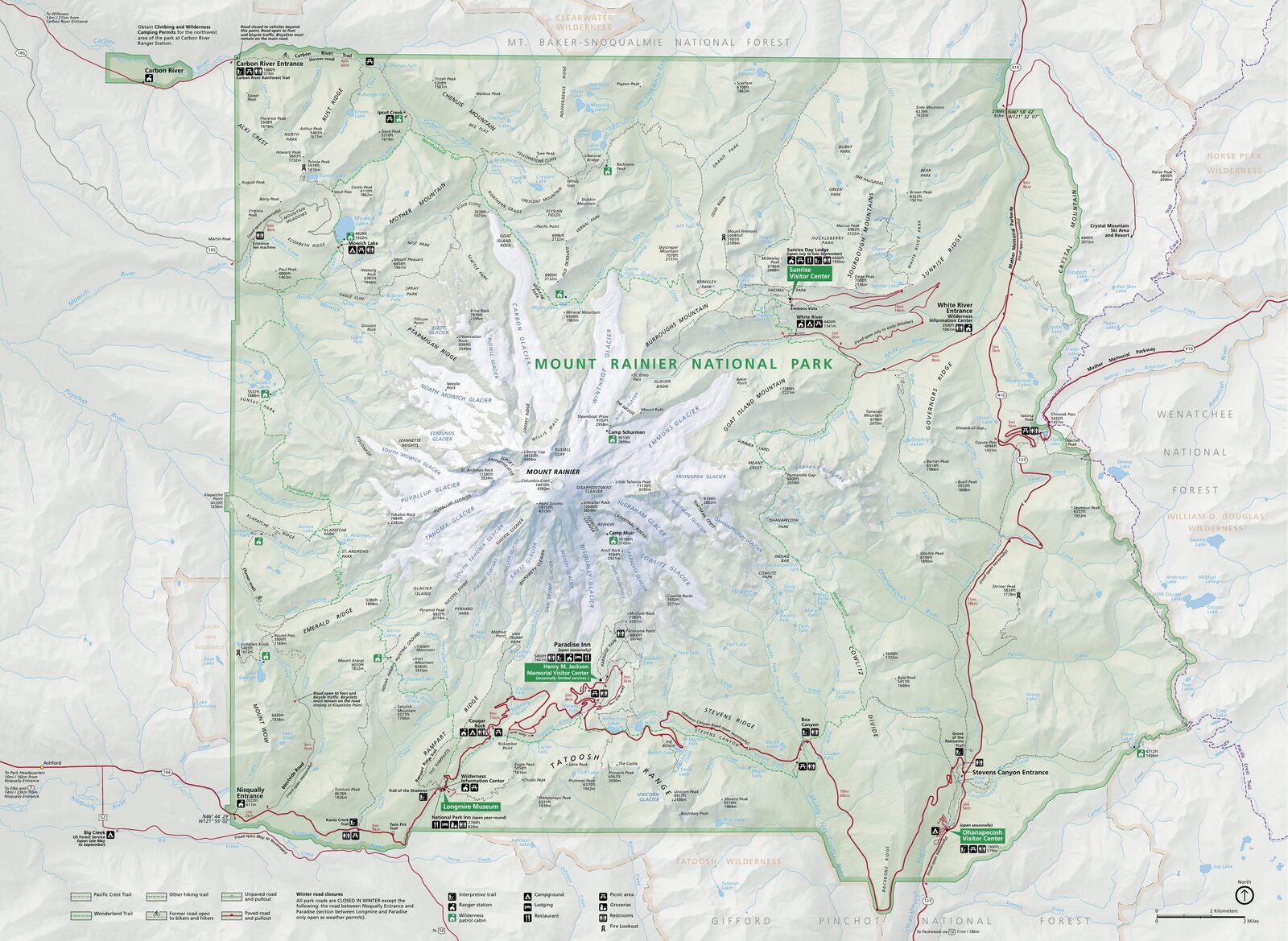
The official park map handed out at entrance stations, with roads, areas, visitor centers and services. View it here or download it for offline use.
Download the map (PDF) Public domain · National Park ServiceWhere Is Mount Rainier?
Mount Rainier National Park is in western Washington State, in the heart of the Cascade Range. The nearest major cities are Seattle, 56 miles northwest; Tacoma, 47 miles west; and Yakima, 81 miles east. Portland, Oregon, is about 174 miles south.
On a map of the United States, the park belongs to the Pacific Northwest's broad volcanic corridor, the same volcanic belt that links Mount St. Helens and Mount Hood. For detailed logistics, including flights, routes, and drive times, see the practical details in the guide to getting to Mount Rainier.
Download the Official Mount Rainier Map (NPS Unigrid)
The National Park Service publishes an official PDF map. This Unigrid map is updated regularly and shows the roads, areas, campgrounds, and main trails. It's free to download, and you don't need to sign up.
You'll find it on Mount Rainier's official NPS Maps page. Print it double-sided on A4 or Letter paper before you leave. Cell service inside the park is almost nonexistent.
For detailed topographic maps showing hiking trails and contour lines, see the dedicated section below.
Mount Rainier's Areas
The park covers just over 367 square miles. It is organized around four distinct geographic areas, each reached by a different road and offering its own character.
Nisqually / Paradise (southwest)
This is the busiest area, accessible year-round via State Route 706 through Nisqually Entrance. At 5,400 feet, Paradise is the starting point for the park's most iconic hikes toward the permanent snowfields. The Henry M. Jackson Visitor Center offers exhibits and maps. Most summit climbs also start here.
Sunrise (northeast)
At 6,400 feet, Sunrise is the highest point in the park that you can reach by car. It offers direct views of Emmons Glacier and the volcano's northeast face. You get there via State Route 410 and White River Road, which are open only during the season, generally from July through October depending on snow conditions.
Carbon River / Mowich Lake (northwest)
This area contains the park's only temperate rainforest, a rarity in this ecosystem. Carbon River Road is restricted to nonmotorized vehicles beyond a certain point, so plan to walk or bring a bike. Mowich Lake, the park's largest lake, is reached by an unpaved road from Wilkeson.
Ohanapecosh (southeast)
This quieter area is known for its old-growth forest of centuries-old cedars and Douglas firs, as well as its hot springs. You get there via State Route 123 from the south. It's a peaceful gateway if you're coming from the Yakima or Oregon side.
Park Entrances and Internal Roads
Mount Rainier has several official entrances, each with an entrance station:
- Nisqually Entrance (southwest): Open year-round, this is the park's main gateway. For GPS, use 39000 State Route 706 E, Ashford, WA 98304.
- White River Entrance (northeast): Access to the Sunrise area; closed in winter.
- Carbon River Entrance (northwest): Access to the rainforest area; open seasonally, with partial restrictions on motorized vehicles.
- Stevens Canyon Entrance (southeast): Connects Paradise and Ohanapecosh via Stevens Canyon Road, which is closed in winter.
No road crosses the park from one end to the other. Each area has its own access route. Paradise Loop Road and Sunrise Road do let you visit several areas in one day if the weather cooperates. For complete information on traffic rules and current speed limits, generally 35 mph, see the Getting Around Mount Rainier guide.
Points of Interest and Viewpoints on the Map
Here are the landmarks to find on your map before entering the park:
- Reflection Lakes (south, Stevens Canyon Road): A classic view of the volcano reflected in the lakes, especially at sunrise.
- Panorama Point (from Paradise, hike): A 360-degree view of the volcano and surrounding glaciers.
- Sunrise Point Lookout (northeast, accessible by car): A panorama of Emmons Glacier, the largest glacier in the United States outside Alaska by area.
- Grove of the Patriarchs (Ohanapecosh area): A grove of thousand-year-old trees on a river island, easy to spot on the map by its suspension bridge.
- Myrtle Falls (from Paradise, 10-minute walk): A waterfall framed by the volcano, a frequently photographed view.
For a complete list of things to do and recommended time at each spot, see activities and must-see sights at Mount Rainier or the complete park guide.
Nearest Cities and Airports
The most convenient airport is Seattle-Tacoma International Airport (Sea-Tac, SEA), about 56 miles from Nisqually Entrance. Allow 1.5 to 2 hours of driving time depending on traffic. Portland (PDX) is an option if you're combining your visit with Mount Hood or Mount St. Helens. It's about a 3-hour drive to Nisqually Entrance via I-5. For lodging near the park, in Ashford, Packwood, and Enumclaw, the Mount Rainier lodging guide lists options by area.
Hiking Maps and Paper Topographic Guides
The NPS Unigrid map is enough for driving directions and locating the areas. For hiking, you'll need a 1:25,000 or 1:50,000 topographic map covering the high-country zones.
Two reliable options:
- National Geographic Trails Illustrated #217 (Mount Rainier National Park): A waterproof, laminated map at 1:35,000, with rated trails and regulated areas. Available from specialty travel bookstores or online.
- Green Trails Maps #269/270: A local series widely used by rangers and experienced hikers, with a 1:69,500 scale and compact format.
If you're looking for a complete paper guidebook with trail descriptions, specialty travel bookstores such as cartovia.com carry several titles dedicated to Mount Rainier.
Frequently Asked Questions
Where is Mount Rainier located?
Mount Rainier is in Washington State, in the western United States, in the Cascade Range. The national park surrounding it is about 56 miles southeast of Seattle.
What's the difference between Mount Rainier and Olympic National Park?
Mount Rainier and Olympic National Park are two separate parks in Washington State. Mount Rainier is an active stratovolcano in the heart of the Cascades. Olympic covers a coastal peninsula with temperate rainforests, beaches, and mountains. They lie on opposite sides of Puget Sound, about a 2-hour drive from each other.
Is there an official Mount Rainier map to download?
Yes. The NPS Unigrid map is available as a free PDF at nps.gov/mora. It covers roads, areas, campgrounds, and main trails.
Can you drive across Mount Rainier?
No road crosses the park from end to end. Each area, including Nisqually/Paradise, Sunrise, Carbon River, and Ohanapecosh, has its own access route. Stevens Canyon Road connects Paradise and Ohanapecosh, but it closes in winter.
What is the closest city to Mount Rainier?
Ashford is the closest town to the main Nisqually Entrance. The nearest major city is Tacoma, 47 miles away, and the most accessible international airport is Seattle-Tacoma International Airport (Sea-Tac), about 56 miles away.
How long does it take to visit Mount Rainier?
A single day lets you see Paradise and one or two secondary areas. Two days allow a comfortable visit to Sunrise, Ohanapecosh, and Carbon River. For hikes and climbs, plan on more time. The Mount Rainier itinerary guide can help you build your plan.