
Gates of the Arctic Map: Layout, Regions, and Official Map Download
Gates of the Arctic covers more than 13,100 square miles north of the Arctic Circle in the Brooks Range of Alaska. No roads enter the park, and no marked trails crisscross its territory. The official NPS PDF map is available free on the National Park Service website. Download it before you leave, since you'll lose all connectivity once you're in the field.
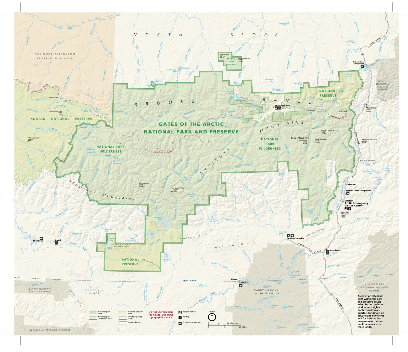
The official park map handed out at entrance stations, with roads, areas, visitor centers and services. View it here or download it for offline use.
Download the map (PDF) Public domain · National Park ServiceWhere Is Gates of the Arctic?
Gates of the Arctic occupies the central Brooks Range in northern Alaska, entirely north of the Arctic Circle (66° 33' N). Fairbanks, the state's main Interior hub, lies about 186 miles south of the park. On a map of the United States, the park sits in a corner most people have never looked at twice. Alaska faces Russia across the Bering Strait, just 53 miles apart at its narrowest point.
Our complete guide to Gates of the Arctic provides the park's broader context to help frame your preparations.
Download the Official Gates of the Arctic Map
The NPS publishes a free Unigrid PDF map on the official website's Maps page. It covers the entire park and the adjoining national preserve, including major rivers, gateway villages (Bettles, Coldfoot, and Anaktuvuk Pass), and essential topographic landmarks. Print it on A3 paper or download it for offline use before leaving Fairbanks. For navigation in the Arctic wilderness, you'll need to supplement it with large-scale USGS maps (see the section below).
The Regions of Gates of the Arctic
The park has no official zoning. Five geographic regions stand out naturally on the map.
South Slope: John and Alatna Valleys
This is the most frequently used gateway. Bettles, on the park's southern edge, is the usual starting point for expeditions into these valleys, which gradually transition from boreal forest to open tundra.
Arrigetch Peaks (Central-West)
Rising more than 6,600 feet, these granite spires draw climbers and experienced hikers to the Arrigetch Peaks. Access is by charter flight from Bettles, followed by a hike along the Alatna River. This is strictly off-trail terrain with no markings of any kind.
The Arctic Gates (Central)
The park's symbolic heart is formed by Frigid Crags and Boreal Mountain, which frame the North Fork Koyukuk River. Explorer Robert Marshall named them the "Gates of the Arctic" in 1930. These two peaks gave the park its name.
Anaktuvuk Pass (East)
The only permanent village inside the park, Anaktuvuk Pass is home to the Iñupiat Nunamiut community, whose presence in these mountains goes back several thousand years. The village has a visitor center and direct air service from Fairbanks.
Noatak River (Northwest)
The Noatak River rises in the park and flows more than 435 miles west to the Chukchi Sea. This Wild and Scenic River corridor offers one of Alaska's most spectacular canoeing or packrafting expeditions. To plan the trip, see things to do in Gates of the Arctic.
Access to the Park: No Roads, No Trails
Gates of the Arctic has no road entrance. The Dalton Highway follows the park's eastern boundary without ever entering it. You can reach the park only by bush plane from Fairbanks, Bettles, or Coldfoot, or on foot from the Dalton Highway after several days of off-trail travel. The park is open year-round, with no entrance fee. Coldfoot's Arctic Interagency Visitor Center is the best place to pick up paper maps and a safety briefing. Charter airlines and departure logistics are covered in how to get to Gates of the Arctic.
Points of Interest to Find on the Map
Here are a few landmarks to locate on your Unigrid before you leave:
- Frigid Crags / Boreal Mountain: the original two "gates," on the North Fork Koyukuk River.
- Walker Lake: a staging area for expeditions to the Arrigetch Peaks, west of the park.
- Tinayguk / North Fork confluence: open tundra and a caribou migration corridor.
- Matcharak Lake: a common launch point for trips down the Noatak River.
Gates of the Arctic itineraries lay out visit plans by region.
Nearest Towns and Airports
| Town | Location | Role |
|---|---|---|
| Fairbanks | ~186 miles south | Main hub, FAI airport, charter flights |
| Coldfoot | eastern side, Dalton Highway | Interagency visitor center |
| Bettles | southern edge of the park | Air stop and expedition starting point |
| Anaktuvuk Pass | inside the park | Iñupiat village and visitor center |
For lodging in Bettles, Coldfoot, or Fairbanks, see where to stay in Gates of the Arctic. Air connections are covered in our access guide.
Hiking Maps and Topographic Guides
The NPS Unigrid map is too general for navigating the Arctic wilderness. Here's the toolkit we recommend.
USGS 1:63,360 topographic maps: the required reference for any expedition. You'll need to identify the map sheets covering your route in advance through the USGS TopoView portal or REI. Plan on three to ten sheets depending on the length of your trek.
National Geographic Trails Illustrated: useful at 1:250,000 for broad planning, but not detailed enough for on-the-ground navigation.
GPS with offline topographic mapping (Garmin inReach recommended): essential for navigation and safety. There's no cell service inside the park, and the device also serves as an emergency beacon.
Frequently Asked Questions
Why is Gates of the Arctic the least-visited national park in the United States?
Gates of the Arctic is the least-visited American national park because you can't reach it by road, and it has no visitor infrastructure inside. Getting there requires an expensive bush flight and complete self-sufficiency in an Arctic environment, so the experience is reserved for visitors who are prepared and properly equipped.
Which towns are located at the Gates of the Arctic?
The communities closest to Gates of the Arctic are Bettles (the main departure point on the park's southern edge), Coldfoot (on the Dalton Highway, with an interagency visitor center), and Anaktuvuk Pass (an Iñupiat village inside the park, accessible by air). Fairbanks, about 186 miles south, is the departure hub for nearly all visitors.
Does Gates of the Arctic have polar bears?
No. Gates of the Arctic is an inland park, far from the Arctic coast where polar bears live. Species found here include grizzly bears, black bears, wolves, caribou, and Dall sheep. The Gates of the Arctic wildlife guide covers their populations and the best times to see them.
Where is Alaska on a world map?
Alaska occupies the northwestern tip of North America, sharing its eastern border with Canada's Yukon and facing Russia to the west across the Bering Strait. Gates of the Arctic lies in the northern half of the state, entirely north of the Arctic Circle.