
Everglades Map: Layout, Areas, and the Official Map to Download
The Everglades occupy the southern tip of Florida, between Miami and the Gulf of Mexico. The national park covers about 2,355 square miles of wetlands, sawgrass prairies, and coastal mangroves. The official Unigrid map is available as a free PDF on the National Park Service website, and staff hand it out at every entrance station.
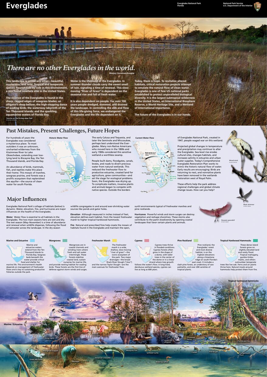
The official park map handed out at entrance stations, with roads, areas, visitor centers and services. View it here or download it for offline use.
Download the map (PDF) Public domain · National Park ServiceWhere Are the Everglades?
The Everglades stretch across southern Florida, in Miami-Dade and Monroe counties. On a map of the United States, look for the tip of the Florida peninsula. Where the land gradually dissolves into Florida Bay and the Gulf of Mexico, you'll find the park.
The main entrance, the Ernest F. Coe Visitor Center, is in Homestead, about 37 miles southwest of downtown Miami. The park stretches more than 93 miles from east to west.
To place the Everglades in the context of South Florida and the region's parks and sites, our Region guide covers the essential landmarks. For an overview of the park before you dive into the details, our complete Everglades guide brings together everything you need to know.
The Official Everglades Map (NPS Unigrid) to Download
The National Park Service publishes a free map known as the Unigrid map. It covers the park's three areas, paved roads, main trails, and camping areas. Staff hand it out at every entrance station, and it's also available as a PDF on the NPS website.
Here's a practical tip. Download it before you leave. Cell service is nearly nonexistent inside the park, especially around Flamingo. A paper map remains by far the most reliable tool in the field.
The Everglades Areas
The park is organized around three access areas with no internal road connections between them. Identifying them ahead of time will keep you from losing half a day correcting a wrong turn.
Ernest F. Coe Area (Main Entrance, Homestead)
This is the busiest gateway, accessible from Homestead via State Road 9336. The main road crosses the park for about 37 miles to Flamingo, its terminus on Florida Bay. Along the way, it serves major sites including Royal Palm (Anhinga Trail), the Pa-hay-okee prairies, Long Pine Key, and the mangroves around Flamingo.
Shark Valley Area (North, Tamiami Trail)
Shark Valley lies on Tamiami Trail (US-41), about 28 miles west of Miami. This area has a 15-mile loop that's open to hikers and cyclists, as well as guided tram tours, plus a 49-foot observation tower with 360-degree views over the flooded prairies. There's no road connection to the rest of the park, so Shark Valley operates as a separate entrance.
Gulf Coast Area (West, Everglades City)
West of the park, access from Everglades City is mainly by water. This area opens onto the Ten Thousand Islands, a maze of mangroves to explore by kayak or boat. It's the choice for visitors who want to get away from roads and crowds.
Our guide to things to do in the Everglades covers the activities available in each area.
Park Entrances and Driving Between Areas
The three areas aren't connected by internal roads. Getting from Ernest F. Coe to Shark Valley means taking the outside roads again, through Homestead and then onto US-41. Allow about 1 hour 15 minutes for the drive.
Entrance fees (2025):
- Private vehicle: $35, valid for 7 days
- Motorcycle: $30
- Pedestrian or cyclist: $20
- Annual park pass: $70
The park is open 24 hours a day, 7 days a week. Entrance stations are staffed from 8 a.m. to 4:30 p.m. For transportation options to the different entrances, see our guide to getting to the Everglades.
Points of Interest and Viewpoints on the Map
In the Ernest F. Coe Area, mark these stops on your map:
- Anhinga Trail (Royal Palm, 1.9 miles): 0.5 miles of boardwalk right along the water. Alligators and anhingas can be seen up close.
- Pa-hay-okee Overlook (about 18 miles): a viewpoint over the sawgrass prairie.
- Mrazek Pond (about 28 miles): a well-known spot for photographing water birds, and very busy during the dry season.
- Flamingo Marina (37 miles): the road's terminus and the starting point for boat trips on Florida Bay.
At Shark Valley, the observation tower, reached by a ramp, offers the best panoramic view from solid ground.
All trails, with distances and difficulty levels, are listed in our Everglades hiking guide.
Nearest Towns and Airports
Homestead and Florida City are the gateway towns for the Ernest F. Coe entrance, less than 9 miles away. Miami is about 37 miles to the north.
Two airports are worth noting:
- Miami International (MIA): the main airport, about 43 miles from the Ernest F. Coe entrance.
- Fort Lauderdale-Hollywood (FLL): slightly farther away, and often cheaper for some transatlantic routes.
For complete distances, drive times, and car rental options, the Everglades Access guide brings all this information together.
Hiking Maps and Topographic Guides (Paper)
The NPS Unigrid map is more than enough for a classic driving visit with a few stops. If you're planning to kayak in the backcountry of the Ten Thousand Islands or camp outside developed areas, you'll need a detailed topographic map.
National Geographic Trails Illustrated Map No. 243 covers the entire park, including navigable waterways and backcountry campsites. Check specialist map retailers for paper copies and delivery options to your location.
Frequently Asked Questions
Where are the Everglades?
The Everglades are in the far south of Florida, about 37 miles southwest of Miami. The national park spans Miami-Dade and Monroe counties, between the Atlantic coast and the Gulf of Mexico.
Is there an official Everglades map, and can you download it?
Yes. The National Park Service publishes an official Unigrid map that's available as a free PDF on the NPS website, and staff hand it out at the park entrance. It covers the three main areas, paved roads, and the main trails.
Can you drive across the Everglades?
The three areas, Ernest F. Coe, Shark Valley, and Gulf Coast, aren't connected by internal roads. In the Ernest F. Coe Area, the main road runs about 37 miles to Flamingo, its terminus on Florida Bay.
What's the best place to visit in the Everglades?
It depends on what you're looking for. Anhinga Trail at Royal Palm is short, accessible, and spectacular for wildlife. Shark Valley is a good fit for cyclists and visitors who enjoy wide-open spaces. Gulf Coast draws kayakers. Our Things to Do page compares the options based on your interests and pace.
How long do you need to visit the Everglades?
Half a day covers Anhinga Trail and a few stops along the main road. A full day lets you add Shark Valley. For all three areas, plan on at least two days. Our Everglades itinerary guide lays out several options based on the time you have.
What is the closest town to the Everglades?
Homestead and Florida City are the closest towns to the main Ernest F. Coe entrance, less than 9 miles away. Miami is about 37 miles to the north.