
Rocky Mountain National Park Map: Layout, Areas, and Official Map Download
Rocky Mountain National Park stretches across northern Colorado, straddling the Continental Divide in the Rockies. The park has four separate entrances, two very different sides, and an alpine road linking them at elevations above 12,100 feet. In other words, you'll want a map before you get behind the wheel. The official NPS Unigrid map is free to download directly from the National Park Service website.
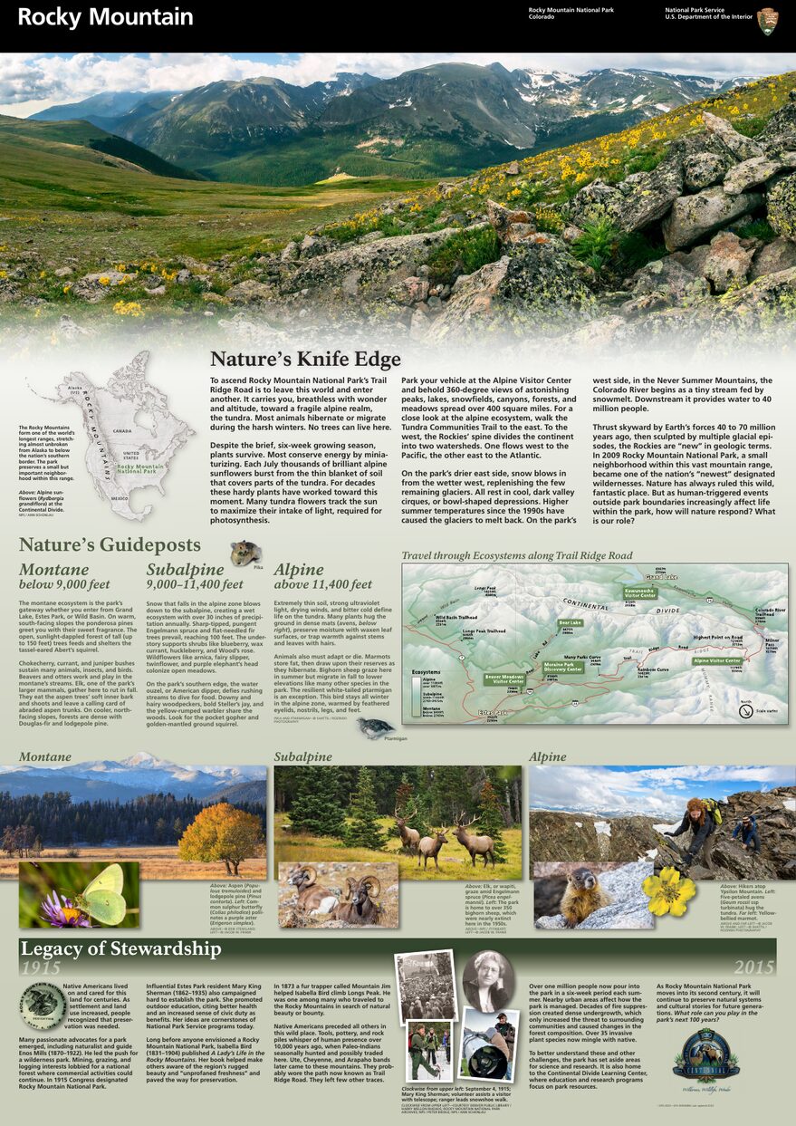
The official park map handed out at entrance stations, with roads, areas, visitor centers and services. View it here or download it for offline use.
Download the map (PDF) Public domain · National Park ServiceWhere Is Rocky Mountain National Park?
Rocky Mountain National Park is in northern Colorado, about 65 miles northwest of Denver. It occupies part of the central Rockies and crosses the Continental Divide, the ridgeline separating the Atlantic and Pacific watersheds.
Elevations range from about 7,900 feet to more than 13,940 feet at the highest summits. That extreme change in elevation explains the variety of landscapes: high-elevation meadows, conifer forests, and alpine tundra stretching to the horizon. On a map of the American West, the park sits halfway between Denver and the Wyoming border, well inland. Our complete Rocky Mountain guide covers the entire park if you're just starting to plan your trip.
Download the Official Rocky Mountain Map (NPS Unigrid)
The NPS publishes a free Unigrid map as a PDF and updates it every season. It covers the entire park, including roads, entrances, trails, campgrounds, and points of interest marked with icons. You'll also receive one at every park entrance station.
Download it from nps.gov/romo/planyourvisit/maps.htm before you leave. We strongly recommend it because cell service is nonexistent across most of the park, including Trail Ridge Road.
Rocky Mountain Areas
The map divides the park into three clearly distinct geographic areas, each with its own character.
The East Side (Estes Park Area)
This is the park's busiest area. It has most of the marked trails, the main campgrounds, and the visitor centers. The Bear Lake area includes several easily accessible alpine lakes, including Bear Lake, Dream Lake, and Sprague Lake, as well as trailheads leading toward the summits. Farther north, Horseshoe Park and Moraine Park are broad high-elevation meadows where elk, black bears, and mule deer regularly appear early in the morning. The Rocky Mountain wildlife guide explains the best viewing windows for each season.
The Alpine Area: Trail Ridge Road
Between the two sides, Trail Ridge Road crosses the park for about 47 miles and reaches 12,183 feet, making it the highest paved road crossing a national park in the United States that is open to the public. Above tree line, you'll enter the alpine tundra, with low-growing vegetation, strong winds, pikas, and marmots everywhere. The Alpine Visitor Center, perched at 11,795 feet, is the main stopping point. The road is generally open from late May through mid-October, depending on snowfall.
The West Side: Kawuneeche Valley (Grand Lake Area)
Kawuneeche Valley follows the headwaters of the Colorado River for about 12 miles. The atmosphere is completely different, with aspen forests, more elusive wildlife, and far fewer visitors. Views of the Never Summer Mountains more than make up for the lower trail density. If you're looking for peace and quiet, this is where you'll be sent first.
Park Entrances and Driving Across the Park
The park has four main entrances.
- Beaver Meadows (U.S. Highway 36): the main east entrance, with direct access to the Visitor Center and the Bear Lake shuttle.
- Fall River (U.S. Highway 34): the northeast entrance, with access to Horseshoe Park and the start of Trail Ridge Road.
- Grand Lake (U.S. Highway 34): the only west entrance, and the starting point for Kawuneeche Valley.
- Wild Basin (Colorado Highway 7 south): a low-key southeast entrance, ideal for hikers heading into the lower forests.
You can drive across the park from east to west via Trail Ridge Road from about late May through mid-October. The speed limit is 40 mph at most, and lower in areas with wildlife. Trailers and vehicles longer than 20 feet aren't allowed beyond Many Parks Curve.
For required parking reservations, the reservation system, and free shuttles, the Rocky Mountain access guide covers all the logistics.
Points of Interest and Viewpoints on the Map
Here are a few landmarks to mark on your map before you leave.
- Bear Lake (9,515 feet): an iconic alpine lake, reachable in a 10-minute walk from the shuttle parking lot and the starting point for several trails.
- Forest Canyon Overlook: a viewpoint on Trail Ridge Road with a sweeping view down into a glacier-carved canyon.
- Rock Cut: a parking area and short trail through the alpine tundra, ideal for spotting rock pikas.
- Longs Peak (14,255 feet): the park's highest point, visible from the Fort Collins plain on clear days. The climb is for experienced hikers only. The Rocky Mountain hiking guide details access conditions and required skill levels.
- Moraine Park and Hollowell Park: valley-bottom meadows frequented by elk at dusk.
To build your itinerary around these geographic landmarks, the Things to Do in Rocky Mountain and Visit Itineraries guides offer concrete plans.
Nearest Towns and Airports
Estes Park is the gateway town on the east side. Less than 6 miles from Beaver Meadows Entrance, it has lodging, restaurants, and outdoor shops. Grand Lake serves the same role on the west side, with a smaller, quieter village feel. Lodging in both areas is listed in the Where to Stay in Rocky Mountain guide.
The most convenient airport is Denver International Airport (DEN), about 65 miles from Estes Park, or a 1.5- to 2-hour drive depending on traffic. For transportation options from Denver, the Rocky Mountain access guide covers rental cars and public transportation alternatives.
Hiking Maps and Topographic Guides (Paper)
The NPS Unigrid map is more than enough for a standard visit by car or on the main marked trails. For hikes away from the main routes or summit climbs such as Longs Peak and Flattop Mountain, you'll want a 1:24,000-scale USGS topographic map. The “7.5-minute” series covers the park's different quadrants with detailed contour lines. Cartovia offers several paper maps for Rocky Mountain. They're useful when the network goes down or fog rolls in, and honestly more pleasant to spread across the hood of a 4x4 than to squint at a screen at 12,100 feet.
Frequently Asked Questions
Where is Rocky Mountain National Park?
Rocky Mountain National Park is in northern Colorado, about 65 miles northwest of Denver, in the central Rockies.
Is there an official Rocky Mountain map to download?
Yes. The NPS publishes a free Unigrid PDF map at nps.gov/romo/planyourvisit/maps.htm. You can also pick one up at every park entrance station.
Can you drive across Rocky Mountain?
Yes, via Trail Ridge Road (U.S. Highway 34), which connects Estes Park and Grand Lake for about 47 miles. The road is generally open from late May through mid-October, depending on snowfall. The speed limit is 40 mph at most.
What's the best viewpoint in the park?
Forest Canyon Overlook and Rock Cut, on Trail Ridge Road, offer sweeping views of the alpine tundra. Bear Lake is the must-see spot in the east-side valley. Our Things to Do page covers them along with seasonal access conditions.
How much time do you need to visit Rocky Mountain?
Our Itinerary & Duration guide answers that question based on your pace and interests.
What's the closest town to Rocky Mountain?
Estes Park, to the east, is the park's gateway town, less than 6 miles from the main entrance at Beaver Meadows. Grand Lake serves the west side.