
Guadalupe Mountains Map: Layout, Areas, and Official Map Download
Guadalupe Mountains National Park lies in western Texas, 110 miles east of El Paso, on either side of US 62/180. The park covers four separate areas that aren't connected by an internal road. The official NPS map, in Unigrid format, is available as a free download from the National Park Service website.
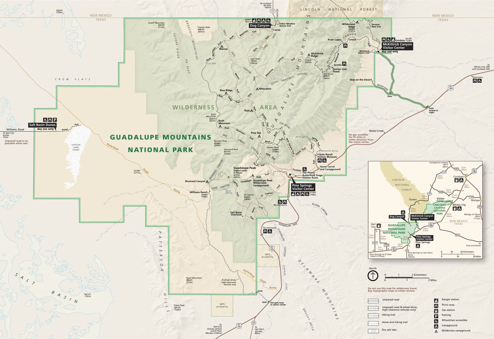
The official park map handed out at entrance stations, with roads, areas, visitor centers and services. View it here or download it for offline use.
Download the map (PDF) Public domain · National Park ServiceWhere Is Guadalupe Mountains?
Guadalupe Mountains National Park occupies the far western edge of Texas, on the border with New Mexico. The Guadalupe Mountains are the northern extension of the Sacramento Mountains, in the heart of the Chihuahuan Desert. US 62/180 runs along the park's southern edge and connects El Paso, 110 miles west, with Carlsbad, New Mexico, about 55 miles northeast. The range reaches its highest point at Guadalupe Peak, the highest point in Texas, at 8,751 feet. Our complete Guadalupe Mountains guide puts the park in its regional and landscape context.
Download the Official Guadalupe Mountains Map (NPS Unigrid)
The NPS publishes a free Unigrid map of Guadalupe Mountains. It covers all four areas, marked trails, and every access road. You can download it as a PDF at nps.gov/gumo/planyourvisit/maps.htm. You'll receive a paper copy at the Pine Springs Visitor Center entrance. Download it before you leave. Cell service is almost nonexistent in the park's remote areas, including Dog Canyon and Salt Basin Dunes.
Areas of Guadalupe Mountains
The park is divided into four geographic areas. Each has its own access from outside the park, and there's no road directly connecting one area to another.
Pine Springs
This is the park's central and busiest area. The Pine Springs Visitor Center, Pine Springs Campground, and trailheads for Guadalupe Peak and El Capitan are all here. You'll find basic services here, including information, restrooms, and drinking water. This area is open year-round.
McKittrick Canyon
You reach McKittrick Canyon via a turnoff east of Pine Springs, still on US 62/180. It's the only canyon in the park with a permanent stream. It's known for its bigtooth maples, whose leaves turn orange and red in the fall, a rarity in this part of the desert. The McKittrick Canyon hike is one of the park's signature trails.
Dog Canyon
Dog Canyon is the isolated northern area, accessible only from New Mexico via NM 137 from Carlsbad. There's no direct road access from Pine Springs. This is the quietest part of the park. Camping is allowed, and visitor numbers remain very low.
Salt Basin Dunes
Salt Basin Dunes stretch along the park's western side in the salt basin. These white gypsum dunes cover nearly 2,000 acres. You reach them by an unpaved clay road that becomes impassable in wet weather. This area is open only from sunrise to sunset, plus 30 minutes, and camping is strictly prohibited. Day use only.
Park Entrances and Internal Roads
The park has no through road, so you can't drive across Guadalupe Mountains from one entrance to another. Each of the four access points connects to a different road outside the park.
- Pine Springs: main entrance on US 62/180; open 24 hours a day.
- McKittrick Canyon: turnoff from US 62/180, east of Pine Springs.
- Dog Canyon: access from New Mexico via NM 137.
- Salt Basin Dunes: access via TX 1576, then an unpaved clay road; closed at night.
The entrance fee is $10 per person and is valid for 7 days. The park's annual pass costs $35.
Points of Interest and Viewpoints on the Map
Here are a few landmarks to locate on the map before your visit:
- Guadalupe Peak: the highest point in Texas at 8,751 feet, accessible from Pine Springs via an 8.4-mile round-trip trail. The Guadalupe Mountains hiking guide covers the route and elevation gain.
- El Capitan: a massive limestone cliff visible from US 62/180 without leaving your car. It's the park's iconic landmark.
- McKittrick Canyon: a wooded canyon with a permanent stream, especially worth photographing in the fall.
- Salt Basin Dunes: a landscape of white dunes in the middle of the desert, surprising and rarely visited.
For the park's activities and must-see spots, the Things to Do section takes a closer look at each one.
Nearest Towns and Airports
The nearest town is Van Horn, Texas, 40 miles east. The two main airports are El Paso (ELP), 110 miles west, and Carlsbad, 55 miles northeast. For driving directions and travel times, see the Guadalupe Mountains Getting There guide.
Hiking Maps and Printed Topographic Guides
The NPS Unigrid map works for the vast majority of visitors. If you're planning high-country hikes such as Guadalupe Peak, Bush Mountain, or the Tejas Trail loop, a 1:24,000-scale topographic map offers useful extra detail. National Geographic Trails Illustrated and MyTopo make suitable waterproof maps. Buy one before you leave at Cartovia or REI. There is no specialty bookstore in Van Horn or at the park entrance.
Frequently Asked Questions
Where are the Guadalupe Mountains?
The Guadalupe Mountains are in far western Texas, on the border with New Mexico. The national park is 110 miles east of El Paso, along US 62/180.
Is there an official Guadalupe Mountains map, and can I download it?
Yes. The NPS Unigrid map is available as a free PDF download at nps.gov/gumo. You'll receive a paper copy at the Pine Springs Visitor Center entrance. We recommend downloading it before you leave because cell service is very limited in the park.
Can you drive across Guadalupe Mountains?
No. The park has no internal road connecting its four areas. Each area, Pine Springs, McKittrick Canyon, Dog Canyon, and Salt Basin Dunes, has its own access from outside the park, so you have to leave the park to travel between them.
What's the best viewpoint in Guadalupe Mountains?
El Capitan, visible from US 62/180 with no hiking required, is the park's iconic view. For a 360-degree panorama, the summit of Guadalupe Peak rewards the climb. The Things to Do section highlights a selection of the best spots.
What is the nearest town to Guadalupe Mountains?
Van Horn, Texas, is the closest community, about 40 miles east. For an international airport, El Paso, 110 miles away, is the main option.
How long does it take to visit Guadalupe Mountains?
One day lets you cover Pine Springs and McKittrick Canyon. To explore all four areas, plan on two to three days. The Guadalupe Mountains itinerary offers sample days based on how much time you have.