
Great Basin Map: Layout, Areas, and the Official Map to Download
Great Basin National Park sits in eastern Nevada, a few miles from the Utah border. The park's official map, a free NPS PDF, is available online, and we'll explain below how to get it. With one main road and areas organized by elevation, finding your way around is easier than it may seem. The park is compact, and its geography makes sense from the bottom up.
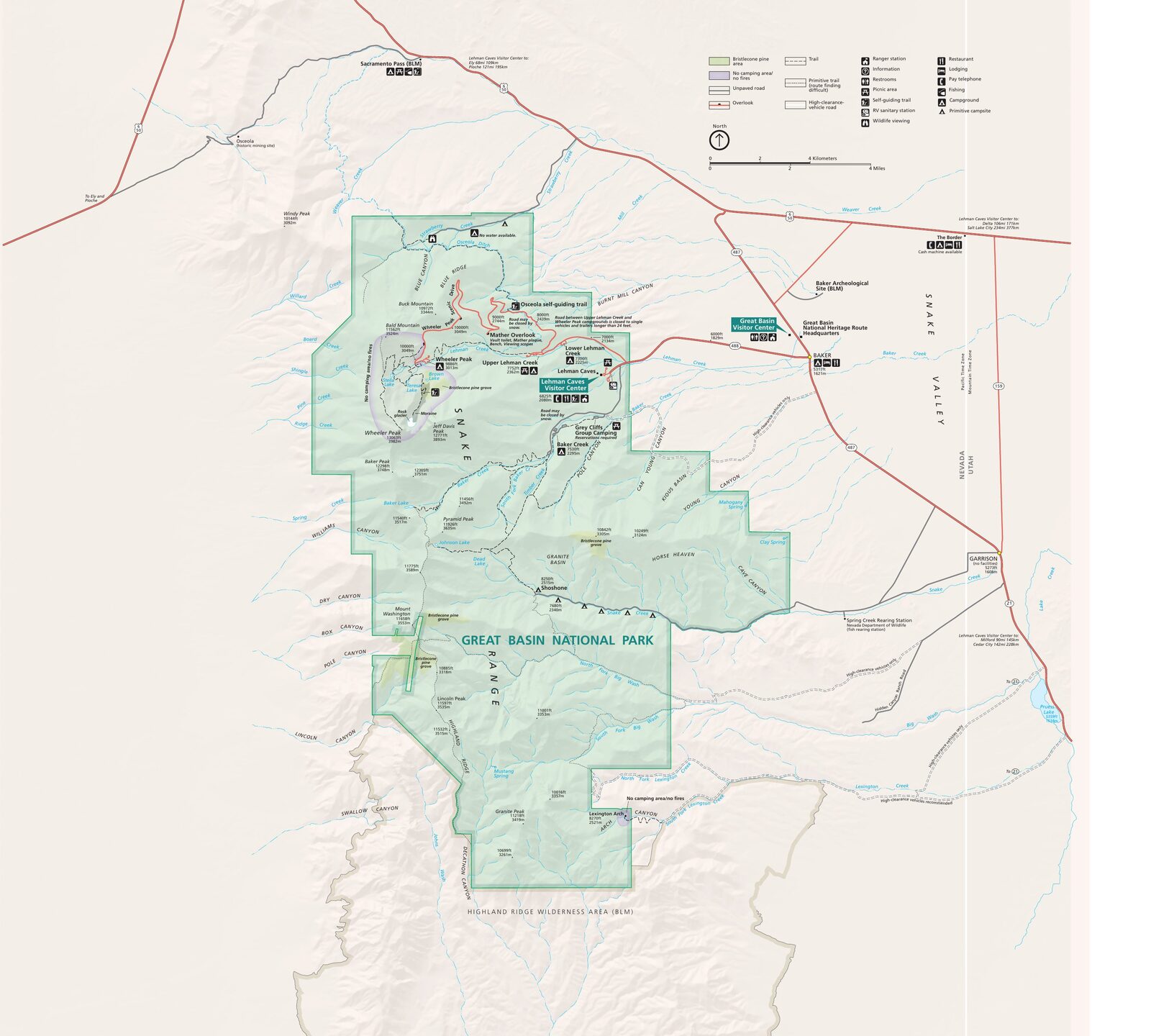
The official park map handed out at entrance stations, with roads, areas, visitor centers and services. View it here or download it for offline use.
Download the map (PDF) Public domain · National Park ServiceWhere Is Great Basin?
Great Basin National Park is in White Pine County, in eastern Nevada, 5 miles west of the small town of Baker, Nevada, and a few miles from the Utah border. On a map of the United States, look for it in the heart of the American West, about 300 miles northeast of Las Vegas and about 300 miles southwest of Salt Lake City.
The park lies within the Snake Range, which rises sharply from the desert plain to Wheeler Peak (13,064 feet), Nevada's second-highest summit. The elevation difference between the valley and the summit reaches nearly 7,900 feet. That vertical range explains the variety of landscapes within just a few miles, as well as the sometimes striking weather differences between the lower and higher parts of the park. The Great Basin weather guide explains what to expect in each season.
For flights, distances, and driving times from major cities, see the guide to getting to Great Basin.
Download Great Basin's Official Unigrid NPS Map
The NPS publishes a free Unigrid map of Great Basin. This double-sided A3 PDF shows the park layout, roads, campgrounds, trailheads, and main points of interest. Keep it available offline before you arrive because cell service is practically nonexistent throughout the park, including at the Visitor Center.
Download it directly from the NPS's official Maps page (nps.gov/grba/planyourvisit/maps.htm). One practical tip: print it in color. The contour lines and areas shaded by zone lose a lot of detail in black and white.
Great Basin's Areas
The park is organized into three distinct geographic areas, from lower to higher elevations.
The Entrance Area (Valley and Lehman Caves)
At about 6,600 feet, you'll find the main entrance and the Lehman Caves Visitor Center. This is where guided tours of Lehman Caves begin. The cave system is made of marble and decorated with stalactites, stalagmites, and calcite shields, making it one of the West's most varied collections of speleothems. This area also includes the first campgrounds and lower-elevation trailheads, which are accessible for much of the year.
The Alpine Area (Wheeler Peak)
Wheeler Peak Scenic Drive climbs 12 miles from the Visitor Center to a parking area at 9,800 feet. This is the park's most spectacular area, with alpine lakes, Stella Lake and Teresa Lake, ancient bristlecone pine forests, and views of the Wheeler Peak Glacier, one of the few permanent glaciers in the Great Basin. The road closes in winter and may remain inaccessible until June, depending on snowfall. The Great Basin alpine-area hikes are covered in the dedicated guide.
The Southern Area (Baker Creek and Lexington Arch)
Wilder and considerably less visited, this area is reached by unpaved roads. Baker Creek Road offers beautiful, peaceful forest hikes. Farther south, the road to Lexington Arch rewards drivers with a vehicle that has adequate ground clearance. There, you'll find a limestone natural arch about 59 feet high, a rare sight in the region.
Park Entrances and Driving Through the Park
Great Basin isn't a through-park. It has one main entrance, on Nevada State Route 488 from Baker, Nevada. You enter and leave by the same road, with no way out on the Utah side.
Wheeler Peak Scenic Drive, a paved 12-mile road, is the only road inside the park. It ends at a dead end in the Wheeler Peak parking area. Speed limits are strictly enforced to protect wildlife, especially the deer and mountain goats you'll often see in the evening.
Points of Interest and Viewpoints on the Map
Here are the spots to mark on your map before you set out:
- Lehman Caves: in the lower part of the park, guided tours only. Space is limited, so reserve ahead at the Visitor Center.
- Bristlecone Pine Grove: accessible from the Wheeler Peak parking area. The trees here are more than 3,000 years old. It puts traffic jams on I-15 in perspective.
- Wheeler Peak Glacier: visible from the alpine trail, and one of the few permanent glaciers in the Great Basin.
- Stella Lake and Teresa Lake: two quiet alpine lakes at about 9,800 feet, perfect for a well-earned break after the climb.
- Lexington Arch: a limestone arch about 59 feet high at the southern end of the park, reached by an unpaved road.
The Great Basin activities guide and the day-by-day itinerary give the time needed for each site.
Nearest Towns and Airports
The nearest town is Baker, Nevada, 5 miles from the entrance. Ely, Nevada, is about 68 miles west and has a regional airport. The main gateways are Salt Lake City, Utah, about 300 miles east, and Las Vegas, Nevada, about 300 miles south. For route options, see our Access & Transportation page.
For places to stay in or near the park, see the Great Basin campgrounds and hotels near the park in the dedicated guides.
Hiking Maps and Guidebooks (Paper)
The NPS Unigrid map is more than enough for the main trails. Hikers who want detailed contour lines in the high country can turn to National Geographic's Great Basin trail map and guide, reference 277, available on Amazon.fr and at specialty travel bookstores. An offline app such as Gaia GPS or Maps.me is a useful addition. Cell service is nonexistent throughout the park, including at the bottom of Scenic Drive.
Frequently Asked Questions
What is the Great Basin of the United States?
The Great Basin is an endorheic region of the American West where no river reaches the sea. Water evaporates or seeps into the ground locally. It covers most of Nevada, western Utah, and parts of Oregon, Idaho, and California. Great Basin National Park is the namesake park for the region, in eastern Nevada.
Why is it called the Great Basin?
The name comes from the region's geography. It forms a vast closed basin with no outlet to the sea. Explorer John C. Frémont is credited with popularizing the term during his expeditions in the American West in the 19th century.
What is the largest desert in North America?
The Great Basin is considered the largest cold desert in North America, covering about 190,000 square miles. Unlike hot deserts such as the Mojave, Sonoran, and Chihuahuan, it has harsh winters and cold nights year-round.
Where is Great Basin National Park?
Great Basin National Park is in White Pine County, in eastern Nevada, 5 miles west of Baker, Nevada, and a few miles from the Utah border. On a map of the United States, it is about 300 miles northeast of Las Vegas and 300 miles southwest of Salt Lake City.
Can you download the official Great Basin map?
Yes. The NPS provides a free Unigrid map of Great Basin as a PDF on its official website (nps.gov/grba/planyourvisit/maps.htm), showing roads, campgrounds, and main trails.
Can you drive through Great Basin?
No. Great Basin isn't a through-park. The only paved road inside the park is Wheeler Peak Scenic Drive, a 12-mile road that ends at a dead end. You enter and leave through the same entrance, on Nevada State Route 488 from Baker, Nevada.
What is the nearest town to Great Basin National Park?
The nearest town is Baker, Nevada, 5 miles from the park entrance, with basic services. Ely, Nevada, about 68 miles west, offers more services and a regional airport.
How much time do you need to visit Great Basin?
One day is enough for Lehman Caves and Wheeler Peak Scenic Drive. Two days let you explore the Baker Creek and Lexington Arch areas as well. Our Itinerary & Timing page offers plans based on how much time you have.