
Yellowstone Map: Areas, Roads, and the Official Park Map
Yellowstone covers nearly 3,500 square miles in the northwest corner of Wyoming, with 3% extending into Montana and 1% into Idaho. The official map is available for free on the National Park Service website. Here's how to find your way around this vast, volcanic landscape.
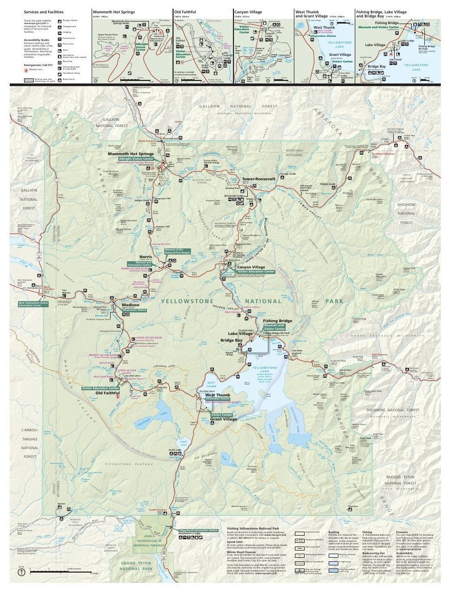
The official park map handed out at entrance stations, with roads, areas, visitor centers and services. View it here or download it for offline use.
Download the map (PDF) Public domain · National Park ServiceWhere Is Yellowstone Located?
Yellowstone sits in the Rocky Mountains of the American West, roughly halfway between Denver and Seattle. The world's first national park, established in 1872, lies within a mountain range at an average elevation of about 7,200 feet. It directly borders Grand Teton National Park to the south, and many visitors combine the two on a road trip.
One thing people often forget is that Yellowstone sits on an active volcanic caldera. This unusual geology explains the concentration of geysers and hot springs across the park. Our general overview of Yellowstone puts the park in its broader regional and geological context.
Download Yellowstone's Official NPS Unigrid Map
The official map is the NPS Unigrid. It's a brochure handed out at every fee entrance and available as a free PDF on nps.gov. It shows the main roads, areas, visitor centers, campgrounds, major geysers, and backcountry boundaries.
Here's a practical tip: download it before you leave. Cell service is almost nonexistent inside the park, so your GPS will be useless and the NPS map will be your best guide.
Yellowstone's Main Areas
The Grand Loop Road forms an inner figure-eight loop connecting the park's five main areas. Here's how the park breaks down geographically.
North: Mammoth Hot Springs
The North Entrance (Gardiner, Montana) leads to Mammoth Hot Springs, the park's only year-round community. You'll find constantly changing active limestone terraces, the park's administrative headquarters, and elk grazing within 6 feet of cars. For the best time to watch the herds, Yellowstone's wildlife guide explains the seasonal windows.
Northeast: Lamar Valley
Lamar Valley is the park's premier wildlife-viewing area, home to bison, grizzlies, coyotes, and wolf packs reintroduced in the 1990s. There's little geothermal activity here, but wide-open spaces stretch as far as you can see. You can reach it through the Northeast Entrance from Cooke City, Montana.
Central: Norris and the Grand Canyon of the Yellowstone
Norris Geyser Basin is the hottest and most acidic hydrothermal basin in the park. To the east, the Grand Canyon of the Yellowstone cuts through ocher and golden cliffs. Inspiration Point and Artist Point overlook Upper Falls and Lower Falls, two of the park's most photographed views.
West: Madison and Old Faithful
This is the park's busiest area. Old Faithful erupts roughly every 60 to 110 minutes, in the heart of the Upper Geyser Basin, which contains more than 500 geysers within a few square miles. Grand Prismatic Spring, the largest hot spring in the United States, is in this same area. For a much better view than you'll get from ground level, take the Fairy Falls Trail overlook. The trails around Old Faithful range from easy to strenuous and are covered in Yellowstone's hiking guide.
South: West Thumb and the Grand Teton Entrance
West Thumb contains a hydrothermal basin along the shore of Yellowstone Lake, where boiling springs meet cold lake water in a striking contrast. Grant Village provides services to the south, including lodging and supplies. The South Entrance opens directly into Grand Teton National Park. To choose between lodges inside the park and accommodations outside it, the Yellowstone lodging guide compares all the options.
Park Entrances and Driving Across Yellowstone
Yellowstone has five entrances.
| Entrance | Nearest town | Vehicle access |
|---|---|---|
| North | Gardiner, MT | Year-round |
| Northeast | Cooke City, MT | Seasonal |
| East | Cody, WY | Roughly April to November |
| South | Grand Teton | Roughly April to November |
| West | West Yellowstone, MT | Roughly late April to early November |
The Grand Loop Road, about 143 miles long, lets you cross the park without leaving it. Driving the full loop without stops takes 4 to 5 hours. The speed limit is 45 mph on most of the route, and much lower when a bison herd blocks the road. That happens regularly and without warning. To plan your stay, the 1- to 3-day itineraries offer practical day-by-day plans.
Yellowstone Map: Points of Interest and Viewpoints
Here are the sites to mark on your map before you hit the road:
- Old Faithful (west), the most famous geyser, with direct access from the visitor center
- Grand Prismatic Spring (west), take the Fairy Falls Trail for an aerial view
- Grand Canyon of the Yellowstone (central-east), head to Artist Point for morning light
- Lamar Valley (northeast), go at dawn or dusk to maximize wildlife sightings
- Mammoth Hot Springs (north), active terraces to combine with your arrival in the park
Yellowstone's must-see sights and activities cover visit lengths and suggested plans for each site.
Nearest Towns and Airports
West Yellowstone and Gardiner are the two gateway towns right outside the park. Jackson, Wyoming, and Bozeman, Montana, are the main air hubs for reaching Yellowstone. Distances, transportation, and transfer options are detailed in how to get to Yellowstone.
Hiking Maps and Paper Trail Guides
The NPS Unigrid map is enough for roadside sites and easy, marked trails. For backcountry and strenuous routes, you'll want a dedicated topographic map:
- National Geographic Trails Illustrated #201 (Yellowstone NP), the standard for hikers, available at specialty bookstores and online
- ITM Yellowstone & Wyoming, a useful regional map for placing the park in its surroundings
- USGS topo maps (1:24,000 scale), for advanced backcountry routes
The official NPS app also lets you download maps for offline use before entering an area without service. Set it up the night before at your hotel.
Frequently Asked Questions
Where is Yellowstone on a map of the United States?
Yellowstone is in the northwestern United States, mostly in Wyoming (96% of its area), with portions in Montana and Idaho. It's in the Rocky Mountains, about 340 miles north of Salt Lake City.
Is there a map of Yellowstone?
Yes. Yellowstone's official map is the NPS Unigrid map, available as a free PDF on nps.gov and handed out at every fee entrance to the park.
Where is the Yellowstone region located?
The Yellowstone region lies in the northern Rocky Mountains, where Wyoming, Montana, and Idaho meet. The so-called Greater Yellowstone Ecosystem actually covers more than 27,800 square miles if you include the surrounding national forests.
Can you drive across Yellowstone?
Yes. The Grand Loop Road, about 143 miles long, crosses the park in an inner loop. Driving the full loop without stops takes 4 to 5 hours. Only the North Entrance at Gardiner is open to cars year-round. The others close in winter.
What is the closest town to Yellowstone?
West Yellowstone, Montana, sits next to the West Entrance, and Gardiner, Montana, is just outside the North Entrance. They're the two most convenient towns for lodging outside the park.
Where is the ranch from the TV show Yellowstone?
The ranch in the TV series Yellowstone, starring Kevin Costner, is fictional. Filming took place in Montana and Utah. Don't confuse it with Yellowstone National Park, which lies primarily in Wyoming.