
Hiking in Virgin Islands: The Best Trails for Every Skill Level
Virgin Islands National Park covers two-thirds of St. John, the wildest of the U.S. Virgin Islands. On less than 10 square miles, the island packs in tropical jungle, turquoise bays, and ruins of colonial plantations. The trails are short by U.S. standards, ranging from 0.5 to 5 miles, but rich in experiences: every trail leads to something tangible, whether it's a beach, a viewpoint, or a historic ruin.
The quick answer. If you only do one hike, make it Ram Head Trail (about 2.2 miles round-trip, moderate). It ends at a volcanic lava headland with 360-degree views of the Caribbean Sea and the neighboring islands. For a full day combining tropical forest, sugar plantation ruins, and Taíno petroglyphs, Reef Bay Trail (5.1 miles) is the park's signature hike. Families with young children will prefer Francis Bay Trail (about 0.7 miles, flat, and rich in birdlife).
How to Prepare for Your Hike in Virgin Islands
Here are a few nonnegotiable points to know before you hit the trail.
Water. There are no drinking-water sources on the trails. Temperatures range from 81°F to 90°F year-round, with pronounced tropical humidity. Plan on at least 0.5 liters per hour per person, and more in the midday sun.
Permits. You don't need a permit for day hikes in the park. Trail access is free and open to everyone.
Dogs. Pets aren't allowed on the national park's trails. This rule applies to every trail.
Vegetation. Two species deserve your attention. Manchineel trees, found along the edges of some beaches, are toxic on contact. Don't shelter under them or touch their fruit. Prickly pear cacti line several trails in the southern part of the island. Stay on the marked path.
Coastal wildlife. Sea urchins and jellyfish may be in the water at beaches reached at the end of a trail. Water shoes are useful if you plan to swim when you arrive.
Hurricane season. From June through November, storms can close trails without warning, and rain can make the ground slippery. Check NPS alerts before every outing. Outside hurricane season, the trade winds bring a steady breeze that makes hiking especially pleasant.
Our guide to the seasons in Virgin Islands explains the month-by-month weather patterns so you can choose the right time to hike.
The Best Hikes, Area by Area
St. John is about 12 miles from east to west. You can divide it into three natural areas: the northwest coast around Cruz Bay, the interior (Centerline Road, Reef Bay, and Bordeaux Mountain), and the southern coast from Coral Bay.
Cruz Bay and the North Shore
These are the easiest trails to reach from the ferry, and some of the most varied in the park.
- Distance
- About 2.5 miles round-trip
- Elevation gain
- 300 feet of elevation gain
- Duration
- 1 hr 15 min to 1 hr 45 min
- Difficulty
- moderate
- Type
- out-and-back (or a partial loop via Caneel Hill Spur)
The trail starts at the Cruz Bay Visitor Center and climbs to Lind Point before descending toward Salomon Beach or Honeymoon Beach. The climb is direct but short. From the top, you get clear views of St. Thomas and the small islands between the two. This trail is ideal for your first morning in the park or one last outing before catching the ferry. The two sheltered beaches below are perfect for extending the walk with a swim.
Trailhead: Cruz Bay Visitor Center. Street parking is limited in town, so arrive early or park near the ferry terminal.
- Distance
- About 0.6 miles round-trip
- Elevation gain
- 130 feet of elevation gain
- Duration
- 20 to 30 min
- Difficulty
- easy
- Type
- out-and-back
You get a direct view of the North Shore for just twenty minutes of effort. The ruined windmill at the top dates to the colonial sugar era and gives the site its character. The view takes in Trunk Bay, Cinnamon Bay, and the islets offshore. It's a short, well-cleared trail that works for everyone.
Trailhead: Small parking lot on North Shore Road (Route 20), between Hawksnest Bay and Trunk Bay.
Cinnamon Bay Self-Guiding Trail About 1.5 miles · minimal elevation gain · 45 min to 1 hr · easy · loop
This is the park's only official, easily accessible loop. The trail passes the ruins of the Cinnamon Bay plantation, one of the island's oldest, dating to the 17th century, and crosses secondary vegetation where fruit trees introduced during the colonial era grow alongside native species. It's an easy way to understand St. John's history without a strenuous climb.
Trailhead: Cinnamon Bay Campground, on North Shore Road.
- Distance
- About 0.7 miles
- Elevation gain
- flat
- Duration
- 30 to 40 min
- Difficulty
- very easy
- Type
- out-and-back
This trail follows the mangrove and the shore of Francis Bay. It's the park's best birding spot that's accessible on foot. Herons, brown pelicans, kingfishers, and frigatebirds are regular visitors. The low morning light on the mangroves is especially beautiful. Pair it with a swim at Francis Bay Beach at the end of the trail.
Trailhead: Francis Bay parking area, on North Shore Road, east of Maho Bay.
The Island's Interior
- Distance
- 5.1 miles round-trip
- Elevation gain
- 850 feet of elevation gain (downhill on the way out)
- Duration
- 3 to 4 hours
- Difficulty
- moderate
- Type
- out-and-back (or one-way with an NPS shuttle)
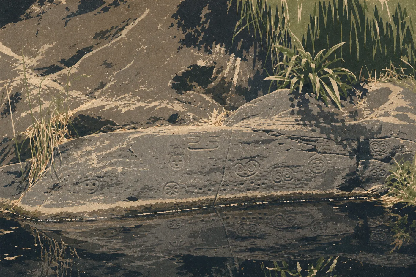
This is the park's signature hike, the one people remember from Virgin Islands. The trail starts high on Centerline Road and descends to Reef Bay Beach, an isolated beach accessible only on foot or by boat. Along the way, you pass through several layers of tropical vegetation, then follow the ruins of Reef Bay Sugar Factory, with walls and vats still standing, one of the best-preserved plantations in the Caribbean. You also reach petroglyphs carved into the rock by the Taíno beside a freshwater pool fed by a seasonal waterfall. Few hikers expect to find pre-Columbian rock art on a tropical trail, but there it is, halfway along.
The 850-foot climb back up in the heat is the trail's main challenge. Set out before 8 a.m. and carry at least 2 liters of water per person. The NPS occasionally runs a boat shuttle from Reef Bay Beach to Cruz Bay. If it's available on your dates, it can change the experience completely. Our guide to getting to St. John explains the shuttle conditions by season.
Trailhead: Trailhead on Centerline Road (Route 10), about 5 miles east of Cruz Bay. Limited roadside parking for 5 to 6 vehicles.
- Distance
- About 3.1 miles round-trip
- Elevation gain
- 590 feet of elevation gain
- Duration
- 2 to 3 hours
- Difficulty
- moderate to strenuous
- Type
- out-and-back
This trail leads to St. John's highest point, Bordeaux Mountain, at 1,276 feet. The slope is steep and steady. As you climb, the vegetation becomes the park's densest, with kapok trees, palms, and tree ferns, a sharp contrast with the dry trails in the south. On a clear day, the summit looks out over Coral Bay and the nearby British islands, including Tortola and Virgin Gorda, to the northeast. This trail sees fewer hikers than Reef Bay, and you can feel it in the atmosphere.
Trailhead: Trailhead on Bordeaux Mountain Road, accessible from Coral Bay.
Coral Bay and the South Coast
The south coast is drier, windier, and wilder. Some of the island's most photogenic trails are here.
- Distance
- About 0.5 miles
- Elevation gain
- minimal elevation gain
- Duration
- 15 to 20 min
- Difficulty
- easy
- Type
- out-and-back
A short path descends to Salt Pond Bay, a bay framed by a salt lagoon and cactus-covered vegetation. The trail is the gateway to two hikes that connect naturally from here: Drunk Bay, branching east, and Ram Head, branching south. The bay itself is good for snorkeling over the seagrass beds to the east.
Trailhead: Salt Pond Bay parking area, at the end of Route 107. Note that the lot is often full by 9 a.m. during the high season, from December through April.
- Distance
- About 2.2 miles from the parking area
- Elevation gain
- 300 feet of elevation gain
- Duration
- 1.5 to 2 hours
- Difficulty
- moderate
- Type
- out-and-back
We come back to it every time we're on the island. From Salt Pond Bay, the trail first follows the beach, then climbs onto a volcanic lava promontory through low prickly pear and scrub vegetation. The horizon gradually opens up. At Ram Head, the 360-degree view of the Caribbean Sea, St. John's wild coast, and the British islands to the northeast is one of the most striking in the park. Stay well back from the edge. The volcanic rock is unstable in places, and the waves below can catch you off guard.
Seasonal tip: hike this trail early in the morning, before 9 a.m., to avoid the heat and enjoy the low light on the sea.
Trailhead: Same parking area as Salt Pond Bay, at the end of Route 107.
- Distance
- About 0.5 miles from Salt Pond Bay
- Elevation gain
- flat
- Duration
- 20 min
- Difficulty
- easy
- Type
- out-and-back
Branching east from Salt Pond Bay Beach, a rocky path leads to Drunk Bay. Nobody swims here because the open-ocean surf is strong and dangerous. The pebble beach and wave-sculpted marine debris create an end-of-the-world atmosphere. The shapes the sea has carved into the black rocks make interesting photographs. Go if you've already hiked Ram Head and the parking lot hasn't become a madhouse yet.
Trailhead: From Salt Pond Bay Beach, take the marked junction east.
Easy Hikes That Work Well for Families
With young children, three trails work especially well: Francis Bay Trail, which is flat, rich in birdlife, and works for kids as young as 3 or 4; Cinnamon Bay Self-Guiding Trail, an easy loop with historical context; and Salt Pond Bay Trail, which is very short and ends at a beautiful beach. Peace Hill Trail also works for children ages 5 or 6 and up.
Skip Reef Bay Trail with toddlers. At 5.1 miles round-trip in the tropical heat, it's a full day for adults. Our Family page lists other activities in the park, including snorkeling at Trunk Bay.
More Demanding Hikes for Views and a Challenge
Reef Bay Trail remains the benchmark for a full day, with the park's highest concentration of points of interest. Bordeaux Mountain Trail gets fewer visitors and is more physical, but it leads through the park's densest vegetation and offers an unusual view over Coral Bay on the eastern side.
If you've only got half a day and your priority is a big viewpoint, Ram Head Trail is the obvious choice: it's short, moderate, and delivers the kind of scenery you find on the best trails in U.S. national parks without requiring the same distance.
Trailhead Access and Parking
St. John has no airport. You get there from St. Thomas via the Red Hook ferry, a 20-minute crossing to Cruz Bay. On the island, you can get around by rental car, which you should book ahead during the high season, by shared taxi, known as safari taxis, the island's typical open-sided pickup trucks, or on foot from Cruz Bay for nearby trails.
One important point: people drive on the left in St. John, a colonial British legacy that has continued since the island became American. Mountain roads are narrow and winding. Get comfortable with the roads before heading to the trailheads.
Main trailheads:
| Trail | Trailhead / parking |
|---|---|
| Lind Point Trail | Cruz Bay Visitor Center |
| Peace Hill Trail | North Shore Road (Route 20), between Hawksnest and Trunk Bay |
| Cinnamon Bay Self-Guiding Trail | Cinnamon Bay Campground, North Shore Road |
| Francis Bay Trail | Francis Bay parking area, North Shore Road (east of Maho Bay) |
| Reef Bay Trail | Centerline Road (Route 10), about 5 miles from Cruz Bay |
| Bordeaux Mountain Trail | Bordeaux Mountain Road, from Coral Bay |
| Salt Pond Bay, Ram Head, Drunk Bay | End of Route 107, on the Coral Bay side |
For Salt Pond Bay and Ram Head, arrive before 9 a.m. during the high season. The lot regularly fills up after that. Our Access & Transportation Guide has ferry schedules and rental options on the island.
When to Hike in Virgin Islands
The park is open year-round. The best hiking window runs from December through April. The trade winds blow regularly, skies are clear, temperatures hover around 79°F to 82°F, rain is infrequent, and humidity stays manageable. From June through November, heat and humidity rise, and hurricane season can close trails or make the ground slippery without warning.
We cover temperatures and rainfall month by month in our When to Go page. Check it before locking in your dates.
Which Hike Is Right for You?
| Hiker profile | Recommended trail |
|---|---|
| Quick viewpoint (30 min) | Peace Hill Trail |
| Half-day hike with sweeping views | Ram Head Trail |
| Full day of history and nature | Reef Bay Trail |
| Family with children | Francis Bay Trail or Cinnamon Bay Self-Guiding Trail |
| Bird-watching | Francis Bay Trail, preferably in the morning |
| Island high point | Bordeaux Mountain Trail |
| End-of-the-world atmosphere | Drunk Bay Trail from Salt Pond Bay |
| First hike from Cruz Bay | Lind Point Trail |
For activities beyond hiking, including snorkeling, kayaking, and visiting the Annaberg ruins, our complete Virgin Islands guide is the place to start.
Frequently Asked Questions
What's the best hike in Virgin Islands National Park?
The hike that consistently tops our recommendations is Ram Head Trail, about 2.2 miles round-trip and moderate. The view from the headland is the island's most striking. For a full day, Reef Bay Trail offers the park's richest experience, combining tropical forest, colonial ruins, and Taíno petroglyphs.
Is hiking in Virgin Islands difficult?
Overall, no. Most trails are short and don't present any particular technical difficulty. The main challenge is the tropical heat, not the terrain. Reef Bay Trail is the most physically demanding, especially on the climb back.
Is it safe to hike in Virgin Islands?
Yes, as long as you start early to avoid the afternoon heat, carry enough water, since there are no water sources on the trails, and stay on marked paths, especially around cacti and the unstable cliff edges at Ram Head. Avoid going out during weather alerts in hurricane season, from June through November.
Do you need a permit to hike in Virgin Islands?
No. All day hikes are freely accessible, with no permit or entrance fee. The NPS boat shuttle on Reef Bay Trail costs extra and requires a separate reservation.
Are there loop hikes in Virgin Islands?
The only officially marked loop is Cinnamon Bay Self-Guiding Trail, about 1.5 miles and easy. Most of the island's trails are out-and-back.
Are there easy hikes for families?
Yes. Francis Bay Trail, about 0.7 miles, flat, and ideal for bird-watching; Salt Pond Bay Trail, 0.5 miles with minimal elevation gain; and Peace Hill Trail, 0.6 miles, all work well for families with children.
Can you hike with your dog in Virgin Islands?
No. Pets aren't allowed on the trails in Virgin Islands National Park.
Is St. Thomas a good destination for hiking?
St. Thomas is a highly developed island, best known for its cruise port and duty-free shopping. Its hiking trails are much fewer and less wild than St. John's. If you want to hike in the U.S. Virgin Islands, St. John and its national park have most of the options.
What activities are available in Virgin Islands National Park?
Hiking is the main land-based activity, but the park also offers snorkeling, including the Underwater Trail at Trunk Bay, one of the most accessible in the United States, visits to sugar plantation ruins such as Annaberg and Reef Bay, and bird-watching in the mangroves. Our What to Do page has the complete list.