

Virgin Islands National Park Map: Areas, Roads, and Official Map Download
Virgin Islands National Park covers nearly all of St. John, a U.S. territory in the Caribbean. It protects both tropical forest and exceptional underwater ecosystems. The official NPS map is available as a free PDF directly from the National Park Service website.
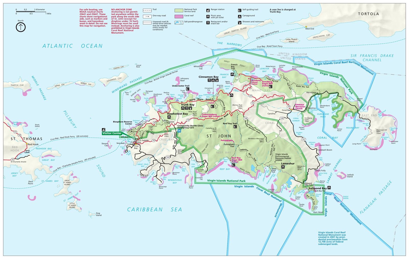
The official park map handed out at entrance stations, with roads, areas, visitor centers and services. View it here or download it for offline use.
Download the map (PDF) Public domain · National Park ServiceWhere Is Virgin Islands National Park?
St. John is the smallest of the three main U.S. Virgin Islands, a U.S. territory in the Lesser Antilles, about 12 miles east of St. Thomas. The island lies roughly 62 miles east of Puerto Rico.
Don't confuse it with the neighboring British Virgin Islands, including Tortola and Virgin Gorda. They belong to the British Crown and fall under a separate jurisdiction. The park described here is American, on U.S. soil.
The park covers most of St. John, along with adjacent marine areas. There's no road access from the mainland, so you can reach it only by sea. Our Virgin Islands access guide covers the ferries and travel options from St. Thomas.
Download the Official Park Map (NPS Unigrid)
The NPS publishes the Unigrid map for Virgin Islands National Park as a PDF, freely available on its official website. It shows all the roads, trails, beaches, and anchorages, along with the main facilities.
Print it before you leave. Cell service can be unreliable in some of the island's interior areas, and the mountain roads leave little room for hesitation at intersections.
Areas of Virgin Islands National Park
The park is organized around three main areas that visitors naturally pass through during their stay.
Cruz Bay and the West Coast
Cruz Bay is the island's main entry point. That's where the ferry from Red Hook, St. Thomas, arrives, and where you'll find the NPS Cruz Bay Visitor Center, open Monday through Thursday from 8:15 a.m. to 4 p.m. and Friday from 8:15 a.m. to 1:30 p.m. Hawksnest Bay and Caneel Bay are just a few minutes north of town by car.
The North Shore and Trunk Bay
North Shore Road serves the island's most popular beaches. Trunk Bay gets the most visitors. Its marked underwater snorkeling trail makes it an almost essential stop. Cinnamon Bay, a little farther east, is home to Cinnamon Bay Campground and the remains of a former colonial sugar plantation. The Annaberg ruins, on the hills above the sea, round out this area's history.
Coral Bay and the East Coast
Coral Bay is the island's second village, much quieter and known for its remote, end-of-the-road atmosphere. Centerline Road, also known as Route 10, provides access across the island's mountainous interior. On the southeast coast, Salt Pond Bay and Lameshur Bay offer a level of solitude that Trunk Bay can no longer promise during the busy season.
Park Entrances and Getting Around by Car
Two ferry services connect Red Hook, St. Thomas, with Cruz Bay, including one car-and-passenger ferry. The crossing takes about 20 minutes. Keep in mind that people drive on the left in the U.S. Virgin Islands. Interior roads are narrow, steep, and winding, and an SUV or Jeep is recommended for secondary roads. For the complete logistics once you're on the island, see getting around Virgin Islands.
Map Highlights and Viewpoints
The most popular spots are spread along the coast and across the island's interior highlands. On the north coast, Trunk Bay, Hawksnest Bay, and Francis Bay appear on every map. At higher elevation, the Bordeaux Mountain overlook, the highest point on St. John, offers views of both sides of the island on a clear day.
In the south, the Ram Head Trail leads to a limestone cliff above the sea. It's one of the few places where you actually walk out over the waves. Things to do in Virgin Islands and the St. John hiking guide give the details and duration for each trail.
Nearest Towns and Airports
The nearest airport is Cyril E. King Airport on St. Thomas (IATA code: STT), about 12 miles from Cruz Bay when you include the ferry crossing. St. John has no airport runway.
The region's main city is Charlotte Amalie, the capital of the U.S. Virgin Islands, on St. Thomas. You can reach it by ferry from Cruz Bay in about 40 minutes. Direct flights connect STT with several U.S. hubs, including Miami, New York, and Atlanta. San Juan, Puerto Rico, is the region's most important hub for transatlantic connections, about an hour away by air. If you're flying from abroad, our park access guide covers possible connections.
Printed Hiking Maps and Trail Guides
Topographic maps published by Trails Illustrated, a National Geographic brand, cover the U.S. Virgin Islands with enough detail for exploring secondary trails. You can find them at specialty travel bookstores or order them online before your trip. For most visits, the NPS Unigrid map is more than sufficient.
Frequently Asked Questions
What is Virgin Islands National Park?
Virgin Islands National Park is a U.S. protected area covering most of St. John, in the U.S. Virgin Islands, along with part of the adjacent seafloor. It was established in 1956 after Laurence Rockefeller donated land to the federal government.
Which islands make up the U.S. Virgin Islands?
The U.S. Virgin Islands include three main islands: St. Croix, the largest; St. Thomas, the air and economic hub; and St. John, the wildest, where the national park is located. They form an unincorporated U.S. territory, separate from the neighboring British Virgin Islands.
Is there an official map of Virgin Islands National Park?
Yes. The NPS publishes a free, downloadable Unigrid PDF map on its website. It shows the park's roads, trails, beaches, and facilities. We recommend printing it before your trip.
Can you drive through the park?
Yes. Route 10, or Centerline Road, crosses the island from Cruz Bay to Coral Bay. The roads are narrow and winding, and people drive on the left in the U.S. Virgin Islands. An SUV or Jeep is recommended for secondary roads.
What is the nearest town to Virgin Islands National Park?
Cruz Bay, on St. John, is the village at the park's main entrance. The closest larger city is Charlotte Amalie, the capital of the U.S. Virgin Islands, on St. Thomas. You can reach it by ferry from Cruz Bay in about 40 minutes.