
Mammoth Cave Map: Park Areas, Layout, and Official Map Download
Mammoth Cave National Park lies in south-central Kentucky, about 100 miles south of Louisville. The park covers just over 81 square miles above ground, but the real story is underground. The Mammoth Cave cave system extends for more than 426 miles of mapped passageways, making it the longest known karst cave system in the world. That figure comes from the NPS and is regularly revised upward as exploration continues. The official NPS map is available as a free download on the park's website. You'll find the direct link farther down this page.
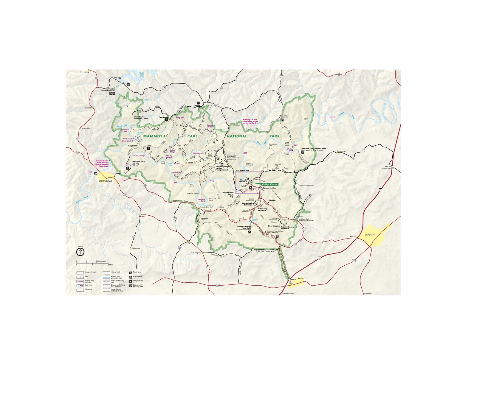
The official park map handed out at entrance stations, with roads, areas, visitor centers and services. View it here or download it for offline use.
Download the map (PDF) Public domain · National Park ServiceWhere Is Mammoth Cave?
The park is in Edmonson County, Kentucky, at the heart of the karst region known as the Pennyroyal Plateau. On a map of the United States, look for Louisville to the north. Mammoth Cave is about a 1-hour-45-minute drive south, just west of Interstate 65.
Geographically, the region belongs to the Interior Appalachians, an area of limestone plateaus where water has seeped underground for millennia and carved out vast cave systems. This is nothing like the big parks of the West. Above ground, the landscape is green, rolling, and almost understated. The drama is hidden below.
To place the park in its regional context, see our Regions section covering the parks of Kentucky and Tennessee.
Download the Official Mammoth Cave Map (NPS Unigrid)
The NPS publishes an official map known as the Unigrid map. It serves as both a surface map and a visitor guide. It shows access roads, trails, cave entrances open to the public, the Visitor Center, campgrounds, and the park's main facilities.
Where to find it. Go to the park's official page at nps.gov/maca and look under “Maps” for the free download. Print it before you leave. Cell service can be unreliable in the wooded areas around the park.
Keep in mind that the surface map gives you an accurate view of the park from above, but the underground passageways aren't shown to scale. No map intended for the general public could do that. For underground orientation, use the maps posted at each tour entrance and follow the rangers who lead every tour.
Mammoth Cave's Main Areas
The park is organized around three distinct areas, all accessible from the central Visitor Center.
Visitor Center and Main Entrance Area
This is the park's operational hub. You'll find the Visitor Center, the departure point for most guided tours, the main parking lots, and the Green River Ferry, a cable ferry that crosses the Green River and still surprises many visitors. Nearly every tour starts here.
Forest and Surface Trails Area
A protected hardwood forest surrounds the Visitor Center and covers nearly all of the park's surface. Marked trails lead to natural cave entrances, overlooks of the Green River, and several picnic areas. The setting is that of a dense temperate forest, far from the desert landscape many people associate with America's national parks.
Green River and Backcountry Area
The Green River crosses the park from east to west. Its north bank is much wilder than the Visitor Center area, and you can reach it on foot or by canoe. This is where you'll find the backcountry campsites, which require reservations, and where amateur birders come to watch wetland species.
For activities available in each area, see our guide to things to do at Mammoth Cave, organized by zone.
Park Entrances and Driving Around
On the map, the park has just one road entrance: Mammoth Cave Parkway, which branches off I-65 at Cave City Exit 53. There is no scenic driving loop. Park at the Visitor Center and explore on foot.
Map Highlights and Overlooks
Mammoth Cave's attractions are spread between the surface and the underground.
Above ground.
- Heritage Trail. This short trail, less than 1.2 miles long, connects the Visitor Center with the historic cave entrance, where African American guides led visitors through the passageways as early as the 19th century. The forest is especially beautiful in spring.
- Green River Bluffs Trail. This trail offers the best river views from the limestone bluffs. Plan on about 3.1 miles round-trip.
- Green River Ferry. This small cable ferry is free for vehicles and is an attraction in its own right. Its operating hours vary by season, so check the schedule at the Visitor Center.
Underground.
All cave entrances open to the public are near the Visitor Center. Each guided tour leads to different passageways, including Frozen Niagara for stalagmite formations, Gothic Avenue for historic inscriptions left by 19th-century visitors, and the deep sections used for adventure tours. The surface map shows where they are, but the guided tour schedule determines which ones are open on the day you visit.
Surface trails, distances, and elevation gains are covered in our Mammoth Cave hiking guide.
Nearest Towns and Airports
Around the park, you'll find Cave City 9 miles east, Bowling Green 28 miles southwest with regional airport BGW, Louisville 100 miles north via I-65 with airport SDF, and Nashville 90 miles south with airport BNA. Louisville and Nashville are the usual air gateways. Compare them based on where you're coming from.
For directions from these cities and transfer options, see our Access & Transportation guide. To decide where to stay, our Mammoth Cave lodging guide covers options inside and around the park.
Hiking Maps and Printed Topographic Guides
The NPS Unigrid map is enough for a standard visit. If you're planning to spend several days in the backcountry or follow the Green River for several stages, a more detailed topographic map is useful.
National Geographic Trails Illustrated publishes a 1:35,000 map of the park in its “Mammoth Cave National Park” series. You can find it at travel bookstores and specialty websites such as Cartovia and Omni Resources. It covers the trail network with contour lines, water sources, and permitted campsites.
The Visitor Center also sells a copy. That's often the easiest option if you arrive without ordering one ahead of time.
Frequently Asked Questions
How do you visit Mammoth Cave?
You can visit Mammoth Cave only on a guided tour reserved in advance through the NPS website, recreation.gov. No passageways are open for self-guided visits. Tours range from 1 hr 15 min to more than 6 hours, depending on the areas explored and the physical difficulty.
How long does a Mammoth Cave tour last?
The length of a Mammoth Cave visit depends on the tour you choose. Allow 2 hours for the shortest tour, the Historic Tour, and a full day if you combine two tours or choose an adventure route. For planning advice, our Mammoth Cave itinerary guide includes sample itineraries.
What is the closest town to Mammoth Cave?
Cave City, Kentucky, is the closest town to Mammoth Cave, about 9 miles east of the park's main entrance. Bowling Green, 28 miles away, offers more services and a regional airport.
Can you drive through Mammoth Cave?
No, you can't drive through Mammoth Cave National Park. Mammoth Cave Parkway leads to the Visitor Center, but no road crosses the entire park. You explore on foot from the central parking area, with rangers leading the underground portion.
Where can you download the official Mammoth Cave map?
The official Mammoth Cave map is available free at nps.gov/maca under “Maps.” It's the NPS Unigrid map in printable PDF format, so you can download it before you leave.
What language is the official Mammoth Cave map available in?
The NPS Unigrid map is in English only, but its graphics showing roads, trails, and buildings are easy to read even if you don't speak the language.