
Lake Clark Map: Layout, Areas, and the Official Map to Download
Lake Clark National Park and Preserve lies in Alaska, on the Alaska Peninsula, southwest of Anchorage. No roads reach it. The park map shows no roads, but it reveals a landscape of active volcanoes, salmon rivers, and wild coastline stretching across more than 10,800 square miles. The official map, a free NPS Unigrid PDF, is available at nps.gov/lacl/planyourvisit/maps.htm.
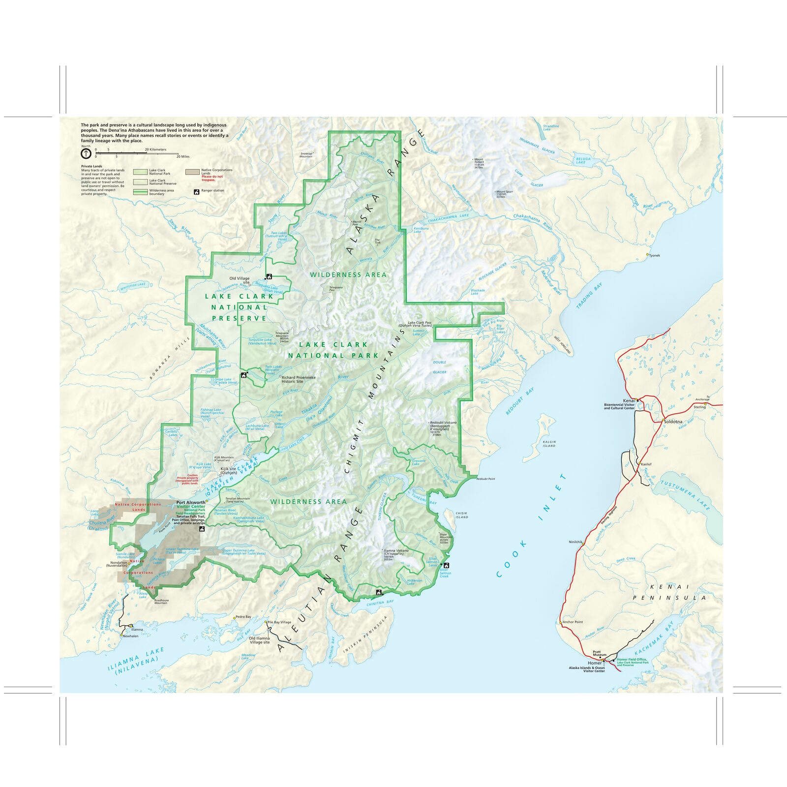
The official park map handed out at entrance stations, with roads, areas, visitor centers and services. View it here or download it for offline use.
Download the map (PDF) Public domain · National Park ServiceWhere Is Lake Clark?
Lake Clark occupies the Alaska Peninsula, where the Chigmit Range, an active volcanic arc, meets the Cook Inlet coast. On a map of the United States, the park lies about 155 miles southwest of Anchorage and north of Katmai National Park.
This location between the sea and high mountains gives the park its dual character. On one side, volcanoes rise more than 9,800 feet and have erupted in the 21st century. On the other, a wild spruce-covered coast draws brown bears when the salmon run begins. For flight and boat options, the Lake Clark access guide covers all the local operators.
Download Lake Clark's Official Unigrid NPS Map
The National Park Service publishes a free Unigrid map in PDF format. It covers the entire park and adjoining preserve, including protected areas, designated Wild and Scenic rivers, elevations of the main peaks, and listed campsites. Print it before you fly in. No cell service will come to your rescue inside the park, and your phone can't replace paper on the tundra.
Download it for free at nps.gov/lacl/planyourvisit/maps.htm. A PDF mirror is also available through Wikimedia Commons (file: "NPS lake-clark-map.pdf").
Lake Clark's Areas
The park and preserve are divided into three major geographic areas, each with a very different feel and access options.
The Cook Inlet Coast
The western side follows Cook Inlet for several dozen miles. This is the park's wettest and mildest area, with precipitation two to four times higher than in the interior. Salmon lagoons and pebble beaches are prime spots for watching brown bears, especially from July through September. Homer, on the Kenai Peninsula, is the usual gateway to this area, a 30- to 45-minute flight away.
The Chigmit Range
The central mountain backbone is home to two active stratovolcanoes: Mount Redoubt, at 10,200 feet, and Mount Iliamna, at 10,000 feet. Redoubt's last major eruption was in 2009, and it's one of Alaska's most closely monitored volcanoes. This area is for experienced mountaineers. Most visitors view it from the inlet or the interior lowlands.
The Interior: Lake Clark, Twin Lakes, and Wild Rivers
To the east, the interior area contains most of the park's visitor facilities. Port Alsworth, the only village within the park boundaries, is home to the visitor center and the main airstrip. Lake Clark, Twin Lakes, known for kayaking, and the wild Chilikadrotna River and Tlikakila River unfold across a landscape of tundra and boreal forest. The climate is more continental here, with warmer, drier summers and harsh winters. The lakes freeze from November through April.
Getting to the Park and Getting Around
The map shows no roads because Lake Clark is accessible only by air taxi, a one- to two-hour flight from Anchorage or a 30- to 45-minute flight from Homer, or by boat. The lakes freeze from November through April. Depending on the season, aircraft land on floats or skis. For air operators and typical fares, see getting to Lake Clark.
Points of Interest on the Map
Here are the landmarks to locate on your map before you leave:
- Port Alsworth: Village and visitor center, and the starting point for most expeditions in the interior area.
- Twin Lakes and Proenneke's Cabin: The park's most visited historic site, accessible by floatplane from Port Alsworth in about 30 minutes. Dick Proenneke lived there self-sufficiently from 1968 to 2000.
- Turquoise Lake: Gateway to high-elevation hikes along the alpine ridges.
- Tuxedni Bay: On the Cook Inlet side, known for salmon fishing and bear watching.
- Mount Redoubt: Visible from the coast on clear days and a central visual landmark on the map.
For planning your visit, things to do in Lake Clark and the hiking guide round out the map.
Nearest Towns and Airports
| Town / airport | Approx. distance | Flight time |
|---|---|---|
| Anchorage (ANC) | 155 miles | 1 to 2 hours |
| Homer (HOM) | 50 miles (to the coast) | 30 to 45 min |
| Kenai (ENA) | 75 miles | about 1 hour |
Anchorage is the main gateway to Alaska's air network. All commercial flights connect there before passengers transfer to an air taxi. Homer is the most convenient option if you're targeting the Cook Inlet coast. Lake Clark brings together booking contacts and advice for each departure point.
Paper Hiking Maps and Topographic Guides
Lake Clark has no official marked trails, so traveling freely across the tundra is the norm. That makes USGS topographic maps at 1:63,360 essential. Specialty retailers such as Cartovia carry the map sheets for the area. In the alpine sections of the Chigmit Range, a waterproof map and compass are still the basic pair. Rely on them, not your phone.
Frequently Asked Questions
Where is Lake Clark on a map of the United States?
Lake Clark National Park and Preserve is in Alaska, on the Alaska Peninsula, about 155 miles southwest of Anchorage and north of Katmai National Park.
Where is Alaska on a world map?
Alaska occupies the northwestern corner of North America, bordered by the Arctic Ocean to the north, the Bering Sea to the west, and the Gulf of Alaska to the south. Lake Clark lies in the southern part of the state, at a latitude comparable to Stockholm or Moscow.
Is there a Lake Clark map I can download?
Yes. The free NPS Unigrid map is available at nps.gov/lacl/planyourvisit/maps.htm. Print it before you leave. There is no cell service in the park.
How do you get to Lake Clark National Park?
Lake Clark isn't accessible by road. You can reach it only by air taxi, a one- to two-hour flight from Anchorage or a 30- to 45-minute flight from Homer, or by boat. The Lake Clark access guide covers all the options and local operators.
Can you drive across Lake Clark?
No. The park has no roads open to vehicles. All travel is by floatplane, boat, or on foot across the tundra.
What is the highest peak in Lake Clark National Park?
Mount Redoubt rises to 10,200 feet. It's an active stratovolcano in the Chigmit Range, with its last major eruption in 2009.
What is the history of Lake Clark?
The lake and park take their name from Captain John W. Clark, an agent for the Alaska Commercial Company who explored the region in the late 19th century. Congress established the park in 1980 under the Alaska National Interest Lands Conservation Act (ANILCA).
What is the closest town to Lake Clark?
Homer, on the Kenai Peninsula, is the nearest served town to the coastal area, a 30- to 45-minute flight away. Inside the park, Port Alsworth is the only permanently inhabited settlement. Anchorage remains the main logistics hub for the park as a whole.