

Hawaiʻi Volcanoes Map: Park Areas, Official Map, and Download
Hawaiʻi Volcanoes National Park is on the Big Island, in the state of Hawaiʻi, 30 miles southwest of Hilo. The park covers two active volcanoes, Kīlauea and Mauna Loa, and stretches from the summit caldera to the Pacific coast. You can download the official NPS map as a free PDF from the National Park Service website. Our complete Hawaiʻi Volcanoes guide provides the rest of the context.
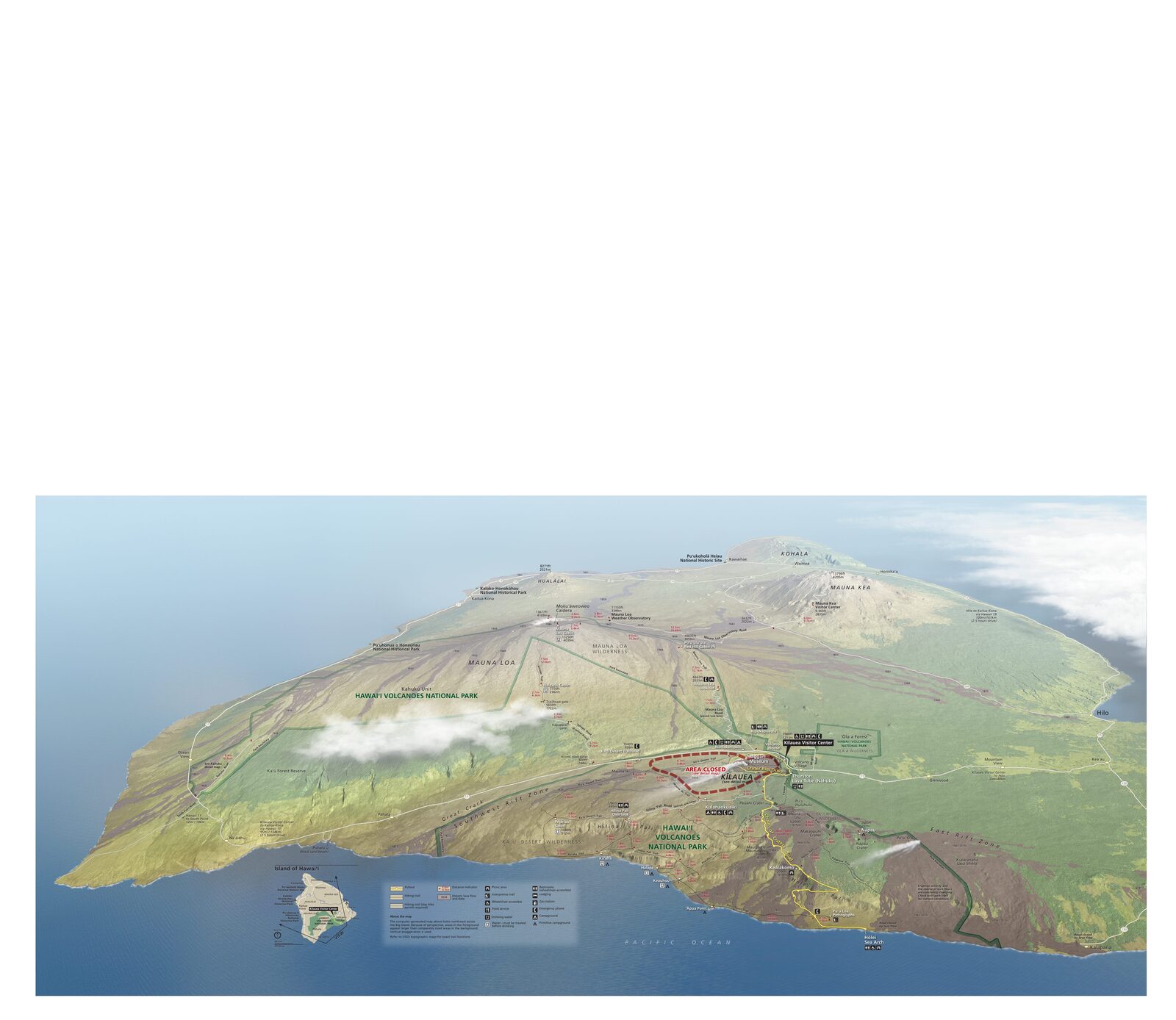
The official park map handed out at entrance stations, with roads, areas, visitor centers and services. View it here or download it for offline use.
Download the map (PDF) Public domain · National Park ServiceWhere Is Hawaiʻi Volcanoes?
Hawaiʻi Volcanoes National Park occupies the southeastern flank of the island of Hawaiʻi, the largest island in the American archipelago. On a map of the United States, the park sits in the middle of the Pacific Ocean, about 2,400 miles southwest of Los Angeles.
The island of Hawaiʻi is the only island in the archipelago with active shield volcanoes. The park protects two of them: Kīlauea, the most frequently active, and Mauna Loa, the largest by volume. The main entrance follows Highway 11, the road that circles the southern part of the island. The Hawaiian archipelago stretches more than 1,500 miles across the Pacific Ocean. The Big Island is the southernmost and the only one with active shield volcanoes.
Download the Official Hawaiʻi Volcanoes Map (NPS Unigrid)
The NPS publishes a Unigrid map, a standardized map brochure updated as volcanic activity causes road closures. It shows open roads, main trails, access points, and the boundaries of each area.
You can download it for free at nps.gov/havo. We recommend printing the map before you leave. Cell service is spotty in the park's more remote areas, especially near the bottom of Chain of Craters Road.
Park Areas
Hawaiʻi Volcanoes is divided into three distinct geographic areas.
Kīlauea Area (Main Entrance and Crater Rim Drive)
This is the heart of the park. The entrance from Highway 11 leads straight to the Visitor Center, just a few minutes' walk from the caldera rim. Crater Rim Drive follows the crater for about 11 miles and provides access to signature sites, including Halemaʻumaʻu Crater, the steam vents at Sulphur Banks, Thurston Lava Tube (Nāhuku), and Kīlauea Iki Overlook. Some sections close periodically depending on volcanic conditions, so check road conditions on the NPS website before you leave.
Kīlauea's summit reaches about 4,000 feet. Weather is unstable year-round, with temperatures 22 to 27°F lower than at sea level and frequent rain, even in summer. The Hawaiʻi Volcanoes weather guide covers seasonal and elevation-related changes in detail.
Chain of Craters Road and the Coast
Chain of Craters Road descends from Kīlauea's summit to the Pacific shore for 33 miles round-trip. The road crosses solidified lava fields, a line of craters, and sea cliffs carved by ancient flows. The coastal plain is hot, dry, and windy, with passing showers. The road ends at a dead end, so plan to turn around there.
Kahuku Unit (Southern Area)
The Kahuku Unit is a separate, less visited area made up of upland forests and grasslands from a former ranch. It's open Thursday through Sunday from 8 a.m. to 4 p.m. and closed Monday through Wednesday. On the map, you'll find it several miles south of the main entrance, still on Highway 11.
Park Entrances and Internal Roads
The park has one main entrance on Highway 11. From Hilo, to the east, it's 30 miles and about a 45-minute drive. From Kailua-Kona, to the northwest, it's 96 miles and a 2- to 2.5-hour drive.
There is no road that crosses the park. You enter and leave through the same main entrance. Crater Rim Drive and Chain of Craters Road are loops or dead-end roads. Sections of Crater Rim Drive may close without notice if sulfur dioxide emissions increase or seismic activity rises.
Entrance fees are $30 per vehicle, valid for 7 days, or $15 per person entering on foot or by bicycle. The park is open 24/7, 365 days a year. To reach the park from Hilo or Kona, see the Hawaiʻi Volcanoes access guide.
Points of Interest and Overlooks on the Map
Here are the sites to mark on your map before you arrive:
- Halemaʻumaʻu Crater: Kīlauea's active caldera, visible from several overlooks along Crater Rim Drive. At night, you may see a glow in clear weather during eruptive phases.
- Kīlauea Iki Overlook: a view over a lava lake that solidified in 1959, which you can cross on foot via the Kīlauea Iki Trail.
- Thurston Lava Tube (Nāhuku): a 600-foot lava tunnel reached by a short forest trail.
- Puʻu Loa Petroglyphs: an ancient field of Hawaiian carvings, reached from Chain of Craters Road by a roughly 1.9-mile round-trip trail.
- Mauna Loa Summit: a 13,700-foot summit accessible only on a multi-day trek of 42 miles one-way.
The Hawaiʻi Volcanoes activities guide covers each site, including time estimates and difficulty levels. For specific hikes, the Hawaiʻi Volcanoes trails guide describes each trail's distance, elevation gain, and duration.
Paper Hiking Maps and Trail Guides
The NPS Unigrid map is enough for marked trails accessible during the day from the Visitor Center. For remote areas such as Mauna Loa and the Kahuku backcountry, a 1:24,000-scale USGS topographic map is recommended.
National Geographic's Trails Illustrated maps cover the Big Island and show the trails in detail. Specialty travel bookstores, such as Ulysse, carry paper guides to Hawaii's parks.
Frequently Asked Questions
Which part of Hawaii has volcanoes?
The Big Island, officially the "Island of Hawaiʻi," is home to the active volcanoes. Hawaiʻi Volcanoes National Park protects the two main ones, Kīlauea and Mauna Loa.
Which volcanoes in Hawaii are the most active?
Kīlauea is the archipelago's most frequently active volcano, with eruptions that continued almost nonstop for several decades. Mauna Loa last erupted in November 2022, after 38 years of dormancy.
What are Hawaii's national parks?
The state of Hawaiʻi has two national parks: Hawaiʻi Volcanoes National Park on the Big Island and Haleakalā National Park on the island of Maui.
What are the best hikes in Hawaiʻi Volcanoes National Park?
The most accessible trails are Kīlauea Iki Trail, a 4-mile crossing of the cooled lava lake; Nāhuku Trail, through Thurston Lava Tube; and the Puʻu Loa petroglyph trail. Our Hiking page describes each trail's difficulty, distance, and duration.
Can you drive across the park?
No, there is no road across the park. The internal roads, Crater Rim Drive and Chain of Craters Road, are dead ends or loops. You enter and leave at the same point on Highway 11.
What is the closest town to Hawaiʻi Volcanoes?
Hilo is the closest town, 30 miles northeast of the main entrance, about a 45-minute drive on Highway 11.