

Great Smoky Mountains Map: Official Map, Areas, and Download
Great Smoky Mountains National Park straddles the Tennessee–North Carolina border in the heart of the southern Appalachians. Its three main entrances are in Gatlinburg, Tennessee, to the north; Townsend, Tennessee, to the northwest; and Cherokee, North Carolina, to the south. The official NPS map, known as the Unigrid, is available as a free PDF at nps.gov/grsm. Details are below.
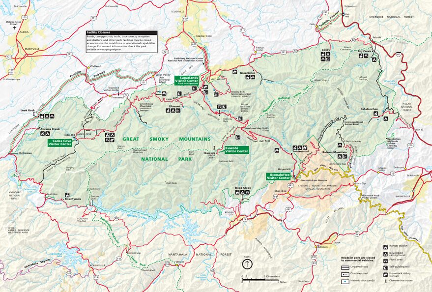
The official park map handed out at entrance stations, with roads, areas, visitor centers and services. View it here or download it for offline use.
Download the map (PDF) Public domain · National Park ServiceWhere Is Great Smoky Mountains?
Great Smoky Mountains lies in the eastern United States, where Tennessee meets North Carolina. The park covers the highest section of the southern Appalachians, about 300 miles northeast of Atlanta, and is within a day's drive for much of the population along the U.S. East Coast. That's part of what accounts for its steady flow of visitors.
Elevations range from 876 feet in the low valleys to 6,644 feet at the summit of Clingmans Dome, the park's highest point. In practice, temperatures can vary from 41 to 52°F between the bottom and top of the same slope. Clear skies in Gatlinburg don't guarantee good weather at 6,600 feet. The Great Smoky Mountains weather guide covers seasonal conditions to help you plan.
Download the Official Great Smoky Mountains Map (NPS Unigrid)
The National Park Service publishes the Unigrid map as a PDF, available free at nps.gov/grsm under “Maps.” It shows the entire park, including the main roads, major trails, visitor centers, campgrounds, and key points of interest.
You can pick up a paper copy at the entrance stations, but it's still a good idea to print the map before you leave. Cell service is very limited across most of the park.
Great Smoky Mountains Areas
The park is organized around two slopes divided by the Appalachian crest.
Tennessee Side (North and Northwest)
Sugarlands Visitor Center, 1.9 miles from Gatlinburg, is the park's busiest point of contact and the natural starting point for the northern half of the park. Farther west, Cades Cove is a historic agricultural settlement surrounded by forests. Its 11.2-mile loop, driven or biked, passes through open meadows where deer, black bears, and wild turkeys are regularly visible at dawn and in the evening. It's one of the busiest areas in the park. Our complete Great Smoky Mountains guide provides an overview of what to see in this part of the park.
The Central Crest and Newfound Gap
Newfound Gap Road (US-441) crosses the park from north to south and passes over the main crest at Newfound Gap, at 5,049 feet. A viewpoint there offers clear views of both sides. From there, a road climbs to Clingmans Dome, at 6,644 feet. You can drive there when the road is open, then walk 0.5 miles to the observation tower. The road closes in winter.
North Carolina Side (South and Southeast)
Oconaluftee Visitor Center, just outside Cherokee, provides access to the southern side. This side is noticeably quieter on weekdays. In the eastern part of the park, Cataloochee Valley, reached by an unpaved road, is home to the elk herd reintroduced in the early 2000s. You're most likely to see them at dawn and dusk. The Great Smoky Mountains wildlife guide covers them in detail.
Park Entrances and Driving Across the Park
Great Smoky Mountains has three main entrances.
- Gatlinburg, TN: northern entrance, the busiest, with access to Sugarlands and Newfound Gap Road.
- Townsend, TN: northwestern entrance, quieter, with access to Cades Cove via Little River Road and Laurel Creek Road.
- Cherokee, NC: southern entrance, with access to Oconaluftee and the North Carolina side.
Newfound Gap Road (US-441), Little River Road, and Laurel Creek Road are open 24/7 year-round, except for occasional weather-related closures. Secondary roads, including Clingmans Dome Road, close during the cold season.
There is no entrance fee. Great Smoky Mountains is one of the few U.S. national parks that remains completely free. For travel logistics from major cities, see our guide to getting to Great Smoky Mountains.
Points of Interest and Viewpoints on the Map
Here are the landmarks to locate on your map before you arrive.
- Clingmans Dome (6,644 feet): the park's highest summit, with a 360-degree observation tower overlooking the Appalachian ridges.
- Cades Cove: an 11.2-mile loop through a historic valley and one of the best places to see the park's wildlife.
- Newfound Gap: a road pass with a viewpoint on the Tennessee-North Carolina border, accessible by car year-round.
- Roaring Fork Motor Nature Trail: a one-way road through dense forest for smaller vehicles only. It closes in winter.
- Cataloochee: an isolated valley in the east, known for elk and quiet.
To build your itinerary around these places, see the Smokies activities guide or the Great Smoky Mountains itinerary guide.
Nearest Cities and Airports
Tennessee side: Gatlinburg borders the park's northern entrance and has a large share of the area's lodging. Pigeon Forge, 8 miles away, adds more options. Knoxville's McGhee Tyson Airport (TYS), about 40 miles from Gatlinburg, is the main air gateway for this side. The Great Smoky Mountains lodging guide compares options on both sides.
North Carolina side: Cherokee is next to the southern entrance. Asheville, less than 60 miles away, has a regional airport (AVL) and makes a good base for exploring the North Carolina side.
Paper Hiking Maps and Topographic Guides
The NPS Unigrid map is enough for driving around and locating the main trails. Hikers heading away from the marked routes will want a 1:24,000-scale topographic map from the USGS series for the necessary level of detail.
National Geographic Trails Illustrated map No. 229 (Great Smoky Mountains) is a favorite among hikers. It covers the park's roughly 800 miles of trails with contour lines, distances, and shelter locations. You can find it at travel bookstores or outdoor-gear retailers. The Great Smoky Mountains hiking guide lists the main trails and their key features.
Frequently Asked Questions
What's the most beautiful part of the Smoky Mountains?
There is no universal answer. Cades Cove appeals to visitors for its open meadows and easy wildlife viewing. The central crest, from Newfound Gap or Clingmans Dome, impresses with its Appalachian panoramas. Cataloochee, in the east, draws travelers looking for peace and elk. The Great Smoky Mountains activities guide helps you choose based on your priorities.
What's the closest town to the Great Smoky Mountains?
On the Tennessee side, Gatlinburg is the gateway town to the north. It literally borders the park entrance. On the North Carolina side, Cherokee plays the same role for the southern entrance. Pigeon Forge, Tennessee, and Asheville, North Carolina, offer more services and lodging.
Why are the Smoky Mountains so popular?
Great Smoky Mountains draws more than 12 million visitors every year, making it the most visited U.S. national park. There are three main reasons: admission is free, the park is accessible by car from across the eastern half of the country, and its mix of scenery, wildlife, and historic heritage makes it a destination for all kinds of travelers.
Where do the Smoky Mountains begin?
The Great Smoky Mountains form part of the southern Appalachians. They begin east of Knoxville, Tennessee, and extend into North Carolina. The main crest, which forms the border between the two states, is the park's backbone.