
Grand Teton Map: Park Areas, Roads, and the Official Downloadable Map
Grand Teton National Park sits in northwestern Wyoming, directly south of Yellowstone. The park covers about 485 square miles around the Teton Range, including Grand Teton, which rises to 13,770 feet. Looking for the official map? The NPS offers a free download on its website (the Grand Teton Maps page), and rangers hand one out at every entrance.
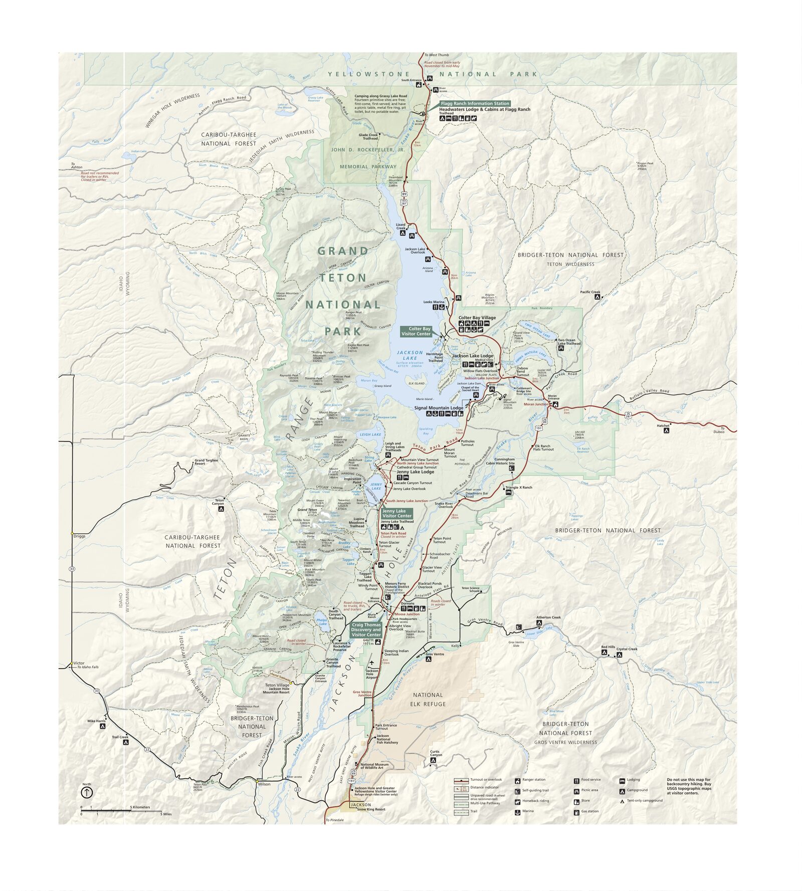
The official park map handed out at entrance stations, with roads, areas, visitor centers and services. View it here or download it for offline use.
Download the map (PDF) Public domain · National Park ServiceWhere Is Grand Teton?
Grand Teton occupies northwestern Wyoming, in the Rockies and at the heart of the Greater Yellowstone ecosystem. Jackson Hole Valley stretches to the east, while the Teton Range rises sharply to the west with no foothills in front of it. On a map of the United States, look for Wyoming's northwestern corner.
Salt Lake City is about 300 miles south, a 5- to 6-hour drive. Denver is more than 560 miles away. Jackson, Wyoming, is just 6 miles south of the main entrance. To see Grand Teton in context with Yellowstone and the surrounding parks, our regional guide provides the big picture.
Grand Teton's Official NPS Unigrid Map to Download
The NPS publishes Grand Teton's Unigrid map as a free PDF on its official website (nps.gov/grte/planyourvisit/maps.htm). It's the reference map for roads, campgrounds, visitor centers, main trails, and parking areas. Rangers hand out a folded paper copy at every entrance.
Practical tip: download it for offline use before entering areas without cell service, or print it on A3 paper for easier reading in the field.
Grand Teton's Park Areas
The park breaks down into four geographic areas, from south to north.
Moose and the South Area
This is the park's main entrance. The Craig Thomas Discovery & Visitor Center in Moose welcomes visitors, with numerous trailheads nearby and Menors Ferry Historic District on the Snake River. It's the busiest area in summer.
Jenny Lake and the Central Area
Jenny Lake draws most of the park's hikers and photographers. The Teton walls drop almost straight down to the lake here. A ferry crosses the lake to trailheads for Hidden Falls and Inspiration Point. Our Hiking page lists routes in this area, along with their distances and difficulty levels.
Colter Bay and Jackson Lake
Jackson Lake occupies the northern part of the park and was partly created by a dam on the Snake River. Colter Bay has a campground, a marina, and a visitor center focused on Native American art. Trails here are noticeably less crowded than those around Jenny Lake.
Antelope Flats and Mormon Row
This flat corridor follows US-191 along the park's eastern side. The historic barns of Mormon Row, listed on the National Register of Historic Places, offer unobstructed views of the entire Teton Range. Bison regularly graze here in the morning. Our Wildlife page explains the best times to look for them.
Park Entrances and Driving Through the Park
Grand Teton has two main vehicle entrances.
The south entrance at Moose is reached via Teton Park Road from Jackson. The Moran Entrance is on the east side, via US-26/89/191, for drivers arriving from eastern Wyoming or Idaho.
Teton Park Road, the park's internal road, runs about 28 miles along the base of the Tetons between Moose and Jackson Lake Junction. It's the road that gets you closest to the peaks. US-26/89/191 follows the park's eastern edge through the valley, with less dramatic terrain but more wildlife visible from the road.
Speed limits are 45 mph on the main roads and 25 mph near developed areas. In midsummer, the Jenny Lake parking lots and popular overlooks fill up before 9 a.m. For access from nearby towns and transportation options, the Grand Teton access guide covers roads, airports, and shuttle options.
Map Highlights and Overlooks
Mark these spots on your map before you set out.
Snake River Overlook offers the view Ansel Adams captured in 1942. A bend in the Snake River fills the foreground, with the Tetons behind it. The parking lot is often full by 9 a.m. during peak season.
Oxbow Bend has calm water that's perfect for reflections and wildlife, including bald eagles, moose, and beavers. You'll get the best results late in the day, when the light is low.
Signal Mountain Summit Road is a 5-mile side road that climbs to the top of Signal Mountain, with panoramic views across Jackson Hole Valley and the Teton Range.
Cathedral Group Turnout sits along Teton Park Road, facing the three major peaks: Grand Teton, Mount Owen, and Teewinot. It's one of the park's most popular photo spots.
Our Things to Do page covers each site in more detail, including the best conditions and practical advice for your visit.
Nearest Towns and Airports
Jackson, Wyoming, is the closest town to the park, about 6 miles south of the main entrance. It has the largest selection of hotels, restaurants, and rental car agencies. For lodging, our Where to Stay page covers everything from lodges to campgrounds.
Jackson Hole Airport (JAC) is a geographic oddity: it's located within the national park itself. For transportation logistics and precise distances from major cities, our Getting There & Transportation page brings the information together.
Hiking Maps and Topographic Guides
The NPS Unigrid map is enough for roads and the main marked trails. For high-elevation or off-trail hikes, we strongly recommend an additional topographic map.
Trails Illustrated No. 202, “Grand Teton” (National Geographic): laminated and waterproof, with contour lines and elevations. It's a field standard, available at specialty travel bookstores and the usual online retailers.
ITM maps (International Travel Maps): useful for a regional overview, but less precise for minor trails.
In the high mountains, glacial crevasses and rockfall pose real hazards. Don't head out without a paper topo map and a GPS device fully charged for offline use.
Frequently Asked Questions
Where is Grand Teton on a map of the United States?
Grand Teton National Park is in northwestern Wyoming, directly south of Yellowstone National Park. Look for the state's northwestern corner on a national map.
Is there an official Grand Teton map I can download?
Yes. The NPS publishes Grand Teton's Unigrid map as a free PDF on its official website. Rangers also hand out folded paper copies at every park entrance.
Can you drive through Grand Teton?
Yes. Teton Park Road crosses the park for about 28 miles between Moose in the south and Jackson Lake Junction in the north. US-26/89/191 follows the park's eastern side. Speed limits are 45 mph on the main roads and 25 mph in developed areas.
What's the best viewpoint in Grand Teton?
The best viewpoint in Grand Teton depends on what you're looking for. Snake River Overlook offers the classic view made famous by Ansel Adams, Oxbow Bend is best for wildlife and reflections, and Signal Mountain offers a panorama of Jackson Hole.
How much time do you need to visit Grand Teton?
The ideal length of a visit depends on your pace and priorities. Our Itinerary & Length of Stay page offers detailed plans for one, two, and three days.
What is the closest town to Grand Teton?
Jackson, Wyoming, is the closest town to Grand Teton, about 6 miles south of the park's main entrance.