
Badlands Map: Layout, Districts, and the Official Map to Download
Badlands National Park is in South Dakota, about 75 miles east of Rapid City. The park covers roughly 378 square miles of eroded sedimentary formations, grasslands, and banded badlands. The official NPS Unigrid map is available free at the entrance and as a PDF download from nps.gov.
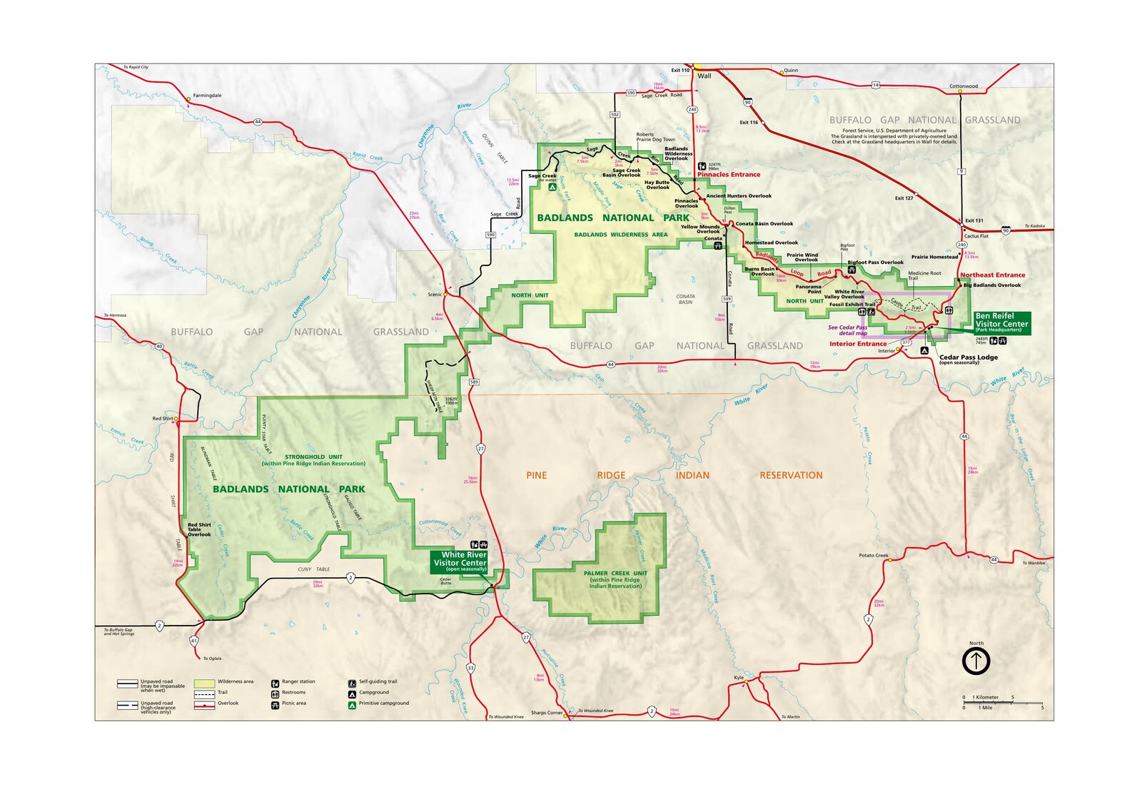
The official park map handed out at entrance stations, with roads, areas, visitor centers and services. View it here or download it for offline use.
Download the map (PDF) Public domain · National Park ServiceWhere Are the Badlands?
Badlands National Park stretches across southwestern South Dakota, at the eastern edge of the Great Plains. On a map of the United States, look for the point halfway between Rapid City to the west and Pierre, the state capital, to the east. I-90 runs along the park's northern edge and provides the main access route from both directions.
The name badlands comes from the Lakota term mako sica, meaning “bad lands.” It describes terrain so deeply eroded by water and wind that farming and ranching are impractical. This landscape is part of the Great Plains, the vast central plain of the United States.
Download the Official Badlands Map (NPS Unigrid)
The National Park Service publishes an Unigrid map as a PDF and updates it regularly. It includes:
- the full route of Badlands Loop Road (SD-240);
- the park's two units, North and South, along with their roads and trails;
- picnic areas, campgrounds, and the main trails;
- GPS coordinates for the entrances and Ben Reifel Visitor Center.
Download: Go to nps.gov/badl and open the “Maps” section. It's free, and no registration is required. You'll also receive a paper copy at the entrance when you pay the $30 vehicle entrance fee.
Badlands Districts
The park is divided into two geographic units with very different characters.
North Unit
This is the busier section, crossed by Badlands Loop Road (SD-240). It includes Ben Reifel Visitor Center, Cedar Pass Lodge, most of the overlooks along the rock formations, and the main marked trails. You can reach the North Unit in a standard passenger car from I-90 via Exit 131 or Exit 110, year-round except during weather-related closures.
South Unit (Stronghold and Palmer Creek)
Far less visited, the South Unit borders Pine Ridge Reservation, home to the Oglala Lakota. Some of its road network requires authorization, and the unpaved roads call for a high-clearance vehicle. If you're looking for solitude, Stronghold Table and Palmer Creek Area offer wide-open views for dozens of miles, with no crowds in sight.
Park Entrances and Driving Across the Park
Badlands National Park has two main entrances on the North Unit side:
- Northeast Entrance: I-90, Exit 131, on SD-240. This is the most frequently used entrance, whether you're coming from Wall or from farther east.
- Northwest Entrance (Pinnacle Entrance): I-90, Exit 110, used mostly by visitors coming from Rapid City.
Badlands Loop Road (SD-240) connects the two entrances in a loop of about 24 miles. The speed limit is 45 mph along most of the route. Driving the entire loop without stopping takes about 45 minutes. Allow at least 2 to 3 hours if you plan to stop at the overlooks. For getting around the park, the Badlands transportation guide covers all your mobility options.
Map Highlights and Overlooks
The most accessible overlooks from Loop Road include:
- Big Badlands Overlook: the first major panorama on the west side, ideal early in the morning when the light is low and warm.
- Yellow Mounds Overlook: ocher, lavender, and rusty-brown formations that are especially photogenic in the late afternoon.
- Pinnacle Overlook: a sweeping view of the Badlands Wall just inside the northeast entrance, often the first photo of the trip.
- Roberts Prairie Dog Town (Sage Creek District): a colony visible from the road, without even getting out of your car.
Each overlook is numbered on the Unigrid map. Things to do in the Badlands and the guide to marked trails cover the trailheads that start at these overlooks. For a first visit, our complete Badlands guide lays out a day-by-day itinerary.
Nearest Towns and Airports
Wall, 6 miles away, and Rapid City, 75 miles away, are the two reference points to know when locating the park. For flights, rental cars, and driving times from these towns, see the guide to getting to the Badlands.
Hiking Maps and Printed Trail Guides
For hikers who prefer a waterproof map in the field, National Geographic Trails Illustrated No. 239 for Badlands National Park covers both units with contour lines, rated trails, and off-trail areas in Sage Creek Wilderness. You can find it at specialty travel bookstores and outdoor retailers, including Cartovia, or sometimes at Ben Reifel Visitor Center.
Frequently Asked Questions
What is a badlands?
A badlands is a type of terrain heavily eroded by water and wind, with cliffs, buttes, and gullies that make the ground unsuitable for farming. In South Dakota, the park's banded formations get their colors from sedimentary deposits built up over tens of millions of years and rich in prehistoric mammal fossils.
Where are the Badlands located?
The Badlands are in southwestern South Dakota, about 75 miles east of Rapid City. I-90 runs along the park's northern edge, and nearly all visitors use it to get there.
What's the most scenic route through the Badlands?
Badlands Loop Road (SD-240) is the signature drive: about 24 miles between the North Unit's two northern entrances, with more than a dozen overlooks along the way. Our detailed Badlands itinerary recommends stops and the best times to visit based on the light.
Is there an official Badlands map I can download?
Yes. The NPS Unigrid map is available free as a PDF at nps.gov/badl in the “Maps” section. It's also handed out at the entrance when you pay the entrance fee.
What's the closest town to Badlands National Park?
The closest town is Wall, South Dakota, about 6 miles from the northeast entrance. Rapid City, 75 miles away, remains the main lodging and airport hub for planning a trip to the Badlands. The Badlands lodging guide lists options in both areas of the park.