
American Samoa Map: Park Areas and Official Map Download
The National Park of American Samoa isn't like most national parks. It isn't one continuous block on the map. Instead, it stretches across three volcanic islands in the South Pacific, separated by hundreds of miles of open ocean. Before you plan your trip, it's essential to understand the park's geography, as well as the departure time for the only flight to the Manuʻa Islands.
The National Park of American Samoa lies in the U.S. territory of American Samoa, in Oceania. You can download the free official NPS map as a PDF at nps.gov/npsa under “Maps.”
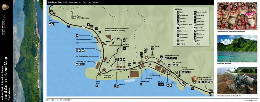
The official park map handed out at entrance stations, with roads, areas, visitor centers and services. View it here or download it for offline use.
Download the map (PDF) Public domain · National Park ServiceWhere Is American Samoa Located?
American Samoa lies in the South Pacific Ocean, between the equator and the Tropic of Capricorn, at approximately 14° S and 170° W. It's the only U.S. territory in the Southern Hemisphere, and therefore the only American national park south of the equator.
The distances are staggering: about 2,600 miles south of Honolulu, Hawaii, 2,300 miles northeast of Auckland, New Zealand, and less than 60 miles east of independent Samoa, whose capital is Apia. For travelers coming from Europe, the most common connection is through Los Angeles and then Honolulu.
The U.S. archipelago includes several islands, but the national park is concentrated on three of them: Tutuila (the main island, where the capital Pago Pago is located), Taʻu, and Ofu (both in the Manuʻa Islands, about 100 miles to the east). These three units share neither roads nor trails. Each one requires separate planning and its own logistics.
The climate is tropical year-round, hot and humid. The rainy season runs from October through May, with a risk of tropical storms. The slightly drier season lasts from June through September. Annual rainfall ranges from 126 inches in coastal areas to 299 inches on the forested peaks. Don't bother waiting for a perfect weather window. Showers are short and frequent, and the forest thrives on them.
To place the archipelago in its regional context, the South Pacific overview provides essential geographic and cultural reference points.
Download the Official American Samoa Map (NPS Unigrid)
The NPS publishes an Unigrid brochure with an integrated map, available as a free download at nps.gov/npsa. It covers all three park units, including marked trails, villages within the park boundaries, and maritime access points. This is the reference document to carry with you, either printed or saved offline on your phone.
In print, the map is available at the park's visitor center in the village of Pago Pago, across from the Pago Way gas station. The center is open weekdays from 8 a.m. to 3 p.m. The park itself is open 24/7 year-round, including holidays. There is no entrance fee, and no reservation is required.
Here's a practical tip: cell service is fairly good on Tutuila but very limited on the Manuʻa Islands. Download the map and trail sheets before you leave. It's essential. Visitor center staff can also provide detailed sheets for individual trails upon request.
American Samoa's Park Areas
The park covers about 13,500 acres, or just under 5,500 hectares, spread across the three islands. Each unit has its own character, ecosystem, and way of visiting.
The Tutuila Unit
Tutuila is the main island of American Samoa. It's home to Pago Pago, the capital, and the territory's only international airport. The park's protected unit extends along the island's northern slopes, encompassing the coastal villages of Vatia, Fagasa, and Afono, as well as a thick band of tropical forest on the ridges above the bay.
Vegetation is dense and low on wind-exposed slopes, and lush and tall in sheltered ravines. Birdlife includes species endemic to American Polynesia. The Samoan fruit bat, a large diurnal fruit-eating bat, is regularly seen at dawn, hanging from the branches of fruit trees along the edge of the villages.
Mount ʻAlava (1,611 feet) is the unit's dominant landmark. The Mount ʻAlava Trail passes through areas of old-growth forest before opening onto a 360-degree view of Pago Pago Bay and its volcanic fjord-like contours. At Vatia, the quiet bay opens toward Pola Island, a basalt column rising from the open sea that appears in most photographs of the park.
The Taʻu Unit
Taʻu is the largest and wildest of the Manuʻa Islands' three units. The park covers nearly the entire island, with the villages of Fitiuta on the northeastern side and Faleasao serving as reference points. No road connects it to Tutuila. The only access is by small plane.
Biologists consider Taʻu's rain forest one of the most intact in American Polynesia. The absence of major hurricane damage for several decades has allowed the canopy to regenerate without interruption. Some trees reach sizes rarely seen elsewhere in the Pacific. Wildlife on land is elusive, but fruit bats and forest birds are abundant.
Taʻu's cliffs plunge more than 950 feet directly into the ocean, with no beach or transition. The sight is dramatic. Trails are less clearly marked than those on Tutuila, and some sections become impassable after heavy rains during the wet season. Be sure to check conditions at the visitor center before setting out.
The Ofu Unit
Ofu is the smallest of the three units and, in many ways, the easiest to explore once you're there. It protects one of the best-preserved coral reefs in the American Pacific. The lagoon water is remarkably clear and shallow along the reef edge, with marine biodiversity that surprises even experienced divers.
Ofu Beach follows the lagoon for about 1.9 miles. Snorkeling starts from the beach, a few dozen yards from shore. Camping in the park, which you must reserve through the NPS, lets you reach the reef early in the morning, before the wind picks up and the midday light arrives. The unit also includes part of neighboring Olosega, which is connected to Ofu by a bridge.
Park Entrances and Travel Between Islands
There is no official park entrance with a gate or ticket booth in American Samoa. The park is integrated into Samoan villages under a land agreement found nowhere else in the United States. The villages retain community ownership of the land and make it available under agreements with the federal government. You enter the park the same way you enter a village.
On Tutuila, the main road, Route 001, connects Tafuna Airport with Pago Pago and serves the park's coastal villages. Traffic drives on the right, as it does throughout the United States. From downtown Pago Pago, allow 30 to 40 minutes to reach Vatia or Fagasa, depending on road conditions. Aiga buses, which are shared minibuses, run regularly along the main routes, but schedules are approximate.
For Taʻu and Ofu, the only access is by air. Small planes with four to nine seats operate from Pago Pago International Airport (Tafuna) to the airfields at Fitiuta on Taʻu and Ofu. The flight takes about 30 to 45 minutes. Flights depend on weather and can be canceled without notice, sometimes for several days in a row. Build extra time into your itinerary. For current operators, schedules, and flight conditions, the guide to getting to American Samoa has the latest information before you leave.
Points of Interest and Lookouts on the Map
On Tutuila, the main sites cluster along the northern ridge and the Vatia coast. Mount ʻAlava offers the island's signature panoramic viewpoint. Vatia Bay is accessible by road and serves as a starting point for coastal walks and kayaking. Fagasa Pass, between the island's two slopes, offers a striking view of the vegetation and volcanic terrain.
On Ofu, everything revolves around the beach. The lagoon is the center of snorkeling, with underwater visibility often exceeding 50 feet. Camping right next to the reef is the best way to enjoy it outside peak hours.
On Taʻu, the cliffs along the southern coast and the heights of the central forested plateau are the most notable sites to locate on the map before you leave. Not all trails are signed, so studying the NPS map carefully before your outing is strongly recommended.
To find activities and hikes for each unit, along with duration and difficulty levels, see the guide to things to do in American Samoa.
Nearest Towns and Airports
Pago Pago is the capital of American Samoa and the territory's only real urban center. It sits directly next to the Tutuila unit of the park, making it the natural logistical base for any stay. You'll find lodging, restaurants, supermarkets, and banking services there.
Pago Pago International Airport (IATA: PPG), located in Tafuna about 8 miles west of downtown, receives nonstop flights from Honolulu, about 5.5 hours away, Auckland, about 4 hours away, and Nadi, Fiji, about 3.5 hours away. Frequencies are limited and schedules change regularly, so booking early and checking availability several months ahead is essential.
For the Manuʻa Islands, the airfields at Fitiuta on Taʻu and Ofu receive only domestic flights from PPG. Lodging is nearly nonexistent apart from the park campground and a few homestays. For island-by-island options and useful contacts for homestays, the American Samoa lodging guide covers each option.
Hiking Maps and Printed Trail Guides
The NPS provides trail sheets at the Pago Pago visitor center, but no commercial large-format hiking map exists for American Samoa. USGS topographic maps at 1:24,000 cover the islands and are the best alternative for hikers who want an accurate paper map. They're available through the USGS Store website or can be ordered from specialized travel bookstores such as Ulysse and Itinéraires.
A general travel guide to Polynesia or the South Pacific, such as Lonely Planet or Rough Guides, can provide useful cultural context, even though coverage specific to the national park remains limited. For trail planning, NPS sheets and travelers' reports on hiking forums are the most up-to-date sources.
Frequently Asked Questions
What is American Samoa?
American Samoa is an unincorporated U.S. territory made up of an archipelago of islands in the South Pacific. The National Park of American Samoa, established in 1988, is the only NPS-managed protected area in the territory. It has one distinction found nowhere else in the United States: the park lands remain owned by Samoan villages, which make them available under a land agreement with the federal government.
What are the seven islands of American Samoa?
American Samoa includes Tutuila, the largest and most populous island; Aunuʻu, a small coastal island off Tutuila; and the Manuʻa Islands: Taʻu, Ofu, and Olosega. Rose Atoll, a marine reserve, and Swains Island, an isolated coral atoll to the north, are also part of the territory. The national park covers portions of Tutuila, Taʻu, and Ofu.
Where is Samoa on the world map?
American Samoa lies in the South Pacific, at about 14° south latitude and 170° west longitude. On a world map, it appears between Hawaii to the north, 2,600 miles away, and New Zealand to the south, 2,300 miles away, just east of independent Samoa, whose capital is Apia.
What is the population of American Samoa?
American Samoa has about 55,000 residents, according to a 2020 estimate, concentrated overwhelmingly on Tutuila. Pago Pago is the territory's administrative and economic capital. The Manuʻa Islands, including Taʻu, Ofu, and Olosega, are sparsely populated, with each village numbering a few hundred residents.