
Wind Cave Map: Layout, Areas, and Official Map Download
Wind Cave National Park lies in southwestern South Dakota, about 11 miles north of Hot Springs and 22 miles south of Custer, along US Highway 385. The park covers nearly 53 square miles of rolling grasslands and ponderosa pine forests, with one of the world's most extensive karst cave systems at its heart. The official NPS Unigrid map is available as a free PDF on the National Park Service website. It's the first thing we recommend getting before you leave.
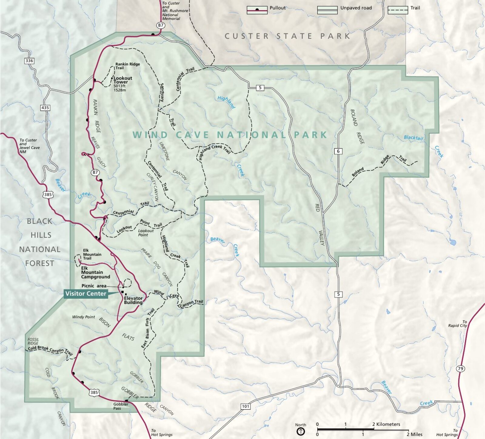
The official park map handed out at entrance stations, with roads, areas, visitor centers and services. View it here or download it for offline use.
Download the map (PDF) Public domain · National Park ServiceWhere Is Wind Cave Located?
Wind Cave is tucked into the Black Hills of South Dakota, along the southern edge of this wooded range of hills that rises sharply above the surrounding Great Plains. The region is sometimes called a "mountain island" because it emerges unexpectedly from the Missouri Plateau, at an average elevation of 3,600 to 4,600 feet.
The park is bordered by Custer State Park to the west, one of the country's best state parks for bison viewing, and by agricultural grasslands to the east. Mount Rushmore is about 31 miles north, while Badlands National Park is 75 miles east. Wind Cave is therefore well placed for a road trip through the Dakotas. For everything related to planning your drive, see the routes and approach roads in the Wind Cave Access Guide.
The Official Wind Cave Map (NPS Unigrid) to Download
The NPS publishes an Unigrid map for Wind Cave. It's the reference document for navigating the park, updated regularly and reliable in the field. It shows the park roads, picnic areas, marked trails, the Visitor Center, campgrounds, and cave access points.
How to get it:
- Free PDF download at nps.gov/wica, in the "Maps" section.
- A paper version is available at the park entrance and at the Visitor Center, about 2,600 feet west of US Highway 385.
Practical tip: print the map before leaving your lodging. Cell service is limited in the park's wooded areas, and the NPS app doesn't work offline by default.
Wind Cave Areas
Wind Cave is a compact park, but it breaks down into two large areas with distinctly different character.
The South Area: Grasslands and Wildlife
The southern half of the park is dominated by open mixed-grass prairies typical of the Great Plains. This is where you'll find the bison herds, numbering about 400 animals, along with pronghorn and prairie dogs. The roads in this area are the easiest places to spot wildlife at sunrise and sunset. The Wind Cave Wildlife page explains the best viewing conditions.
The North Area: Ponderosa Forests and Rugged Terrain
As you head toward Custer, the landscape shifts to ponderosa pine forests and more pronounced terrain. The park's most technical hiking trails are in this area. Rankin Ridge, the park's highest point at about 5,020 feet, offers 360-degree views of the Black Hills. See the Wind Cave hikes for detailed routes.
The Central Area: Caves and Visitor Center
The Visitor Center, the mandatory starting point for all guided cave tours, sits in the center of the park where the two main internal roads meet. This is where you'll find the ticket counters, restrooms, and main parking lot. The caves extend beneath the entire park. The mapped network exceeds 149 miles of passages, making it one of the longest karst systems in the United States.
Park Entrances and Driving Around
Wind Cave has a main entrance on US Highway 385, about 2,600 feet east of the Visitor Center. A second, less busy entrance is accessible from SD Highway 87 to the north, coming from Custer State Park.
Internal roads:
Two main roads run north to south through the park, allowing you to drive all the way across it. Bison Flats Road follows the grasslands to the west, while NPS Road 5 crosses the wooded areas to the east. Both roads are paved and suitable for standard vehicles, but side roads leading to picnic areas may be gravel.
The speed limit inside the park is 45 mph on the main roads and 25 mph in wildlife crossing zones. In winter, snowfall, averaging 30 inches a year, periodically closes some secondary roads. Call 605.745.4600 for current conditions before heading out in the off-season.
Points of Interest on the Map
Here are the landmarks to locate on your map before your visit.
Visitor Center and cave entrance: the essential starting point. All guided tours, including the Candlelight Tour, Natural Entrance Tour, and Fairgrounds Tour, leave from here. Book your tour times in advance, especially in summer.
Rankin Ridge fire lookout tower: in the northern part of the park, accessible via a 2-mile round-trip trail. The tower is one of the few places where you can take in the full sweep of the Black Hills at a glance. It's a must-see map point for anyone looking for a panoramic view.
Cold Brook Canyon Trail: in the southern part of the park, this valley-bottom trail follows an intermittent stream and offers good chances of seeing bison outside the open grasslands.
Elk Mountain Campground: the park's only campground, located 1 mile north of the Visitor Center. Its central location makes it a convenient base for exploring the entire network. For campsites and reservations, see the Wind Cave Camping Guide.
For the full schedule and visit durations, see how to plan your stay at Wind Cave and the park's must-do activities.
Nearest Towns and Airports
Hot Springs (11 miles south) is the closest town to the park. This small community of fewer than 4,000 residents offers a few lodging options, restaurants, and gas stations, making it a good stop before entering the park.
Custer (22 miles north) is a more complete base for supplies, with stores, hotels, a variety of dining options, and direct access to Custer State Park. This is where we stay when we visit Wind Cave for several days.
Rapid City (68 miles northeast) is the region's main city and home to the closest regional airport, Rapid City Regional Airport (RAP). Direct flights and one-stop flights are available from major U.S. cities. For distances, drive times, and car rental options, our Access & Transportation Guide has the details.
Hiking Maps and Printed Topographic Guides
The NPS Unigrid map is enough for the vast majority of visits. If you're planning off-trail hikes or want a more detailed topographic map, a few specialized publishers offer printed maps of the Black Hills region.
Trails Illustrated (National Geographic) publishes a laminated "Black Hills National Forest/Mount Rushmore" map in its Topo Maps series. It covers Wind Cave and the surrounding area at a scale of 1:126,720. It's the go-to reference for serious hikers, with contour lines, rated trails, and water sources. You can find it at specialty travel bookstores or online.
For day trips, our Hiking page lists trails with elevation gain, duration, and required fitness level.
Frequently Asked Questions
How can I visit Wind Cave National Park?
To visit Wind Cave, enter via US Highway 385, park at the Visitor Center, and book a guided cave tour through the NPS website. The park's surface areas, including grasslands and forests, are open to everyone year-round from sunrise to sunset.
How far is Wind Cave from Custer?
Wind Cave National Park is about 22 miles south of Custer, less than a 30-minute drive via SD Highway 89 or US Highway 385.
What is the history of Wind Cave National Park?
Wind Cave is one of the first national parks in the United States, established in 1903 specifically to protect an underground network. Its name comes from the air currents that escape from the natural entrance, caused by differences in atmospheric pressure between the inside and outside of the cave.
Is there an official Wind Cave map to download?
Yes. The NPS offers the Wind Cave Unigrid map as a free download at nps.gov/wica, in the "Maps" section. It's also available as a paper map at the park entrance.
Can you drive across Wind Cave?
Yes. Two main paved roads let you drive through the park from north to south. The full drive takes about 20 to 30 minutes without stops, but wildlife, including bison and pronghorn, frequently slows traffic. That's good news for photos.
What is the closest town to Wind Cave?
Hot Springs, 11 miles south, is the closest town. Custer, 22 miles north, offers more services for a longer stay. The Where to Stay in Wind Cave Guide and our Hotels & Lodges page cover lodging options in both towns.