
Sequoia & Kings Canyon Map: Regions, Roads, and the Official Map
Sequoia & Kings Canyon National Parks stretch across California's Sierra Nevada, about 56 miles east of Fresno. The two parks are jointly managed by the NPS and cover more than 1,350 square miles combined. The official Unigrid map is available as a free PDF on nps.gov/seki. Download it before you leave.
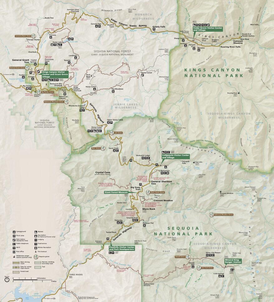
The official park map handed out at entrance stations, with roads, areas, visitor centers and services. View it here or download it for offline use.
Download the map (PDF) Public domain · National Park ServiceWhere Are Sequoia & Kings Canyon?
Sequoia & Kings Canyon lie in central California, on the western side of the Sierra Nevada. Elevations vary dramatically, from 1,700 feet in the Foothills to 14,505 feet at the summit of Mount Whitney on the eastern side of the park. Mount Whitney is the highest point in the contiguous United States. To place the parks on a U.S. map, they're roughly halfway between Fresno in the valley and Nevada in the mountains, well beyond California's Central Valley. Our complete Sequoia & Kings Canyon guide gives you the big picture.
Download the Official Sequoia & Kings Canyon Map (NPS Unigrid)
The NPS publishes the Unigrid map as a free PDF at nps.gov/seki/planyourvisit/maps. It covers both parks on a single map, including roads, regions, campgrounds, visitor centers, and major trails. Print it at A3 size if you can. At that scale, the details for Cedar Grove and Mineral King are readable, unlike on A4.
The NPS also offers online mapping tools on the same site, which are useful for checking road closures in real time.
Sequoia & Kings Canyon Regions
The two parks are divided into five distinct geographic regions, running from south to north and west to east.
The Foothills
This is the entrance region along Highway 198, on the Visalia side. Elevations are low, ranging from 1,640 to 2,950 feet, with Mediterranean vegetation and hot summer temperatures. Ash Mountain Visitor Center is the first stop for visitors arriving along this route.
Giant Forest and Lodgepole
The heart of Sequoia National Park. At 6,560 feet, this forest is home to General Sherman Tree, recognized by the NPS as the world's largest living tree by volume, with 1,487 cubic meters of wood. Lodgepole village has a large campground, a grocery store, and a visitor center. This is the busiest region in both parks.
Mineral King
An isolated region in the south, reached from Three Rivers by a 25-mile road that's not recommended for large RVs. Elevations exceed 7,875 feet, and giant sequoias give way to an alpine landscape. The road closes in winter. Mineral King is for experienced hikers who want to get away from the crowds at Giant Forest.
Grant Grove
The first Kings Canyon region when coming from Fresno via Highway 180. It includes General Grant Tree, one of the world's most impressive giant sequoias, Big Stump Entrance, and Grant Grove Village. It's also the starting point for the drive to Cedar Grove.
Cedar Grove
At the back of Kings Canyon, 30 miles east of Grant Grove. The road drops sharply toward the Kings River at 4,430 feet, while the canyon walls rise more than 7,875 feet above it. The region closes from October through May. Zumwalt Meadow and Roaring River Falls are here.
Park Entrances and Internal Roads
Two main routes provide access to the parks.
Highway 198, from Visalia, leads to Sequoia NP's Ash Mountain Entrance. Inside the park, it becomes Generals Highway and climbs toward Giant Forest and then Grant Grove. Be aware that vehicles more than 23 feet long or 10 feet high face restrictions on some sections.
Highway 180, from Fresno, leads to Kings Canyon NP's Big Stump Entrance, then to Grant Grove, 15 miles away, and Cedar Grove, another 30 miles farther. The Kings Canyon Scenic Byway between Junction View and Cedar Grove follows the canyon for several miles.
The two parks aren't connected by an east-west road. No road crosses the Sierra Nevada here. You enter, explore, and leave from the same side.
Map Highlights and Viewpoints
Moro Rock, in Giant Forest, is a granite dome at 6,725 feet. A staircase with 350 steps cut into the rock leads to 360-degree views of the Sierra Nevada.
Panoramic Point, above Grant Grove, offers an unobstructed view of the snow-capped peaks. You can reach it from the parking lot after a half-mile walk.
Zumwalt Meadow, in Cedar Grove, is a meadow framed by sheer cliffs. It's an easily reached photo spot on a 1.2-mile level walk, often deserted outside the morning hours.
You can locate the points of interest on the SVG map above and on the NPS Unigrid map. For schedules, durations, and details about each site, the Sequoia & Kings Canyon things to do guide lists every site and its access conditions.
Nearest Cities and Airports
Fresno, with airport FAT, is about 1 hour 15 minutes from the Kings Canyon entrance via Highway 180. Visalia is 34 miles from the Sequoia entrance via Highway 198, less than an hour away. Los Angeles, with airport LAX, is about 3.5 hours from the Sequoia Foothills. For flight options, rental cars, and directions from each airport, see the Sequoia & Kings Canyon access guide.
Hiking Maps and Topographic Guides
The Unigrid map is enough for the roads and general orientation. For serious hiking in Mineral King or deep in Cedar Grove, you'll want a detailed topographic map.
Tom Harrison's "Sequoia & Kings Canyon National Parks" maps, at a scale of 1:63,360, are laminated and water-resistant, and hikers consider them the standard reference. They show elevations and estimated hiking times. You can find them at specialty travel bookstores or online. ITM maps also cover the region in a format that's convenient for driving.
Frequently Asked Questions
Where are Sequoia & Kings Canyon on a U.S. map?
Sequoia & Kings Canyon are in central California, in the Sierra Nevada, about 56 miles east of Fresno and 217 miles north of Los Angeles.
Is there an official Sequoia & Kings Canyon map to download?
Yes. The NPS Unigrid map is available as a free PDF at nps.gov/seki. It covers both parks on a single map.
Can you drive through Sequoia & Kings Canyon?
No. There isn't an east-west road through these parks. You enter and leave from the same side, either via Highway 198 on the Visalia side for Sequoia NP or Highway 180 on the Fresno side for Kings Canyon NP.
What's the best viewpoint in Sequoia & Kings Canyon?
Moro Rock, at 6,725 feet in Giant Forest, offers the most unobstructed 360-degree panorama of the Sierra Nevada. Panoramic Point in Grant Grove and the Cedar Grove canyon are also among the most popular spots. Our Sequoia & Kings Canyon things to do page covers the essential sights and access conditions.
What's the closest city to Sequoia & Kings Canyon?
Visalia is the closest city to the Sequoia entrance, 34 miles away via Highway 198. Fresno is closest to the Kings Canyon entrance, about 56 miles away via Highway 180.
How long do you need to visit Sequoia & Kings Canyon?
Plan on at least two days for Giant Forest and Grant Grove. Cedar Grove and Mineral King each warrant an extra day. The Sequoia & Kings Canyon itineraries guide offers plans based on the length of your stay.