
Pinnacles Map: Park Areas, Official Map, and What to Download
Pinnacles National Park is in central California, about 81 miles southeast of San Jose. You can reach the park through two separate entrances: the East Entrance via Highway 25 and the West Entrance via Highway 101 (through Soledad). No road connects them inside the park. The official PDF map is available free on the NPS website before you even hit the road.
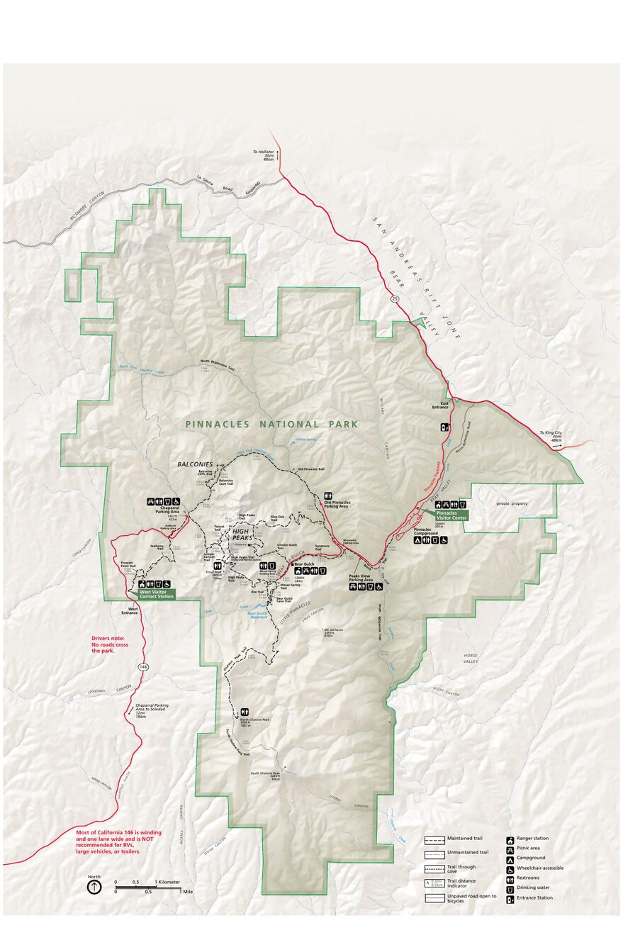
The official park map handed out at entrance stations, with roads, areas, visitor centers and services. View it here or download it for offline use.
Download the map (PDF) Public domain · National Park ServiceWhere Is Pinnacles National Park Located?
Pinnacles sits in California's inland coastal hills, spanning San Benito and Monterey counties, several dozen miles from the Pacific Ocean. On a map of the United States, the key reference points are San Jose, 81 miles north; Salinas, 50 miles northwest; and Fresno, 130 miles east.
Pinnacles isn't part of the classic West Coast Grand Tour, but it fits easily into a road trip between Big Sur and the Bay Area. For distances from major cities and transportation options, the guide to getting to Pinnacles has all the details.
Download the Official Pinnacles Map (NPS Unigrid)
The National Park Service publishes what's known as an Unigrid map. It shows the two areas topographically, along with trails, talus caves, parking areas, and services. You can download it free as a PDF from nps.gov/pinn.
A paper copy is handed to every visitor at the entrance and is included with admission ($30 per vehicle, $15 per person on foot or by bike). For entrance fees and annual passes, see the National Park Entrance Fees & Passes page. Keep the map with you. Cell service inside the park is almost nonexistent. Download the PDF for offline use before you arrive, so you won't get lost between volcanic formations.
Pinnacles' Areas: East and West
Pinnacles is one of the few U.S. national parks whose two halves aren't connected by an internal road. Choose your area before you leave, or plan to drive around the outside if you want to visit both in one day.
East Area: Bear Gulch and the Caves
The East Area has most of the park's infrastructure, including Bear Gulch Visitor Center, Bear Gulch Reservoir, and access to Bear Gulch Cave, one of the park's two talus caves. This is also where California condor sightings are most common, along the High Peaks cliffs. Pinnacles Campground is here as well. The Pinnacles camping guide explains how to make a reservation.
The East Entrance is open 24/7, including holidays.
West Area: Balconies and the Wild Ridges
The West Area is more remote and less crowded. It provides access to Balconies Cave, the other talus cave, the Juniper Canyon Trail, and the Prewett Point overlook. The atmosphere feels wilder, and the trails are more technical.
You reach it via Highway 146 from Soledad, a narrow, winding, single-lane road. RVs and oversized vehicles aren't allowed on this route. The Pinnacles RV guide explains the size restrictions.
Park Entrances and Driving Around
For driving rules, vehicle-size restrictions, and parking, the guide to getting around Pinnacles has all the practical details. One thing to note on the map is that the two entrances aren't connected by an internal road. If you want to visit both areas in one day, allow about an hour to drive around the outside, either via Hollister or King City.
Points of Interest to Find on the Map
Before you arrive, locate these spots on your map:
Bear Gulch Cave: A talus cave in the East Area, reached by a short loop from Bear Gulch Parking Area. It may close during bat nesting season, generally from May through July. Check its status at nps.gov/pinn before you leave.
Balconies Cave: In the West Area, it's wetter and darker than Bear Gulch Cave. Bring a headlamp. It's not optional.
High Peaks Trail: A ridge trail connecting the two areas on foot, not by car. It offers the park's broadest views of the rock formations. The Pinnacles hiking guide includes trail profiles and elevation gains.
California Condors: Look for them high on the cliffs in the East Area. The Pinnacles wildlife guide explains when and where to see them.
For visit plans and timing, the Things to Do section and the Pinnacles itinerary guide answer these questions in detail.
Nearest Towns and Airports
Hollister (19 miles north of the East Entrance): the main town on the east side, with gas stations, small grocery stores, and basic lodging.
Soledad (12 miles northwest of the West Entrance): the gateway to the west side, on Highway 101.
Salinas (50 miles north): a larger city with more lodging and dining options. Our Where to Stay page covers accommodations within a 31-mile radius.
Airports: San Jose (SJC) is about 1.5 hours from the East Entrance, making it the most convenient option for a domestic flight. San Francisco (SFO) is 2.5 hours away and serves more international destinations. Our Access & Transportation guide compares the two airports and lists local car rental companies.
Hiking Maps and Topographic Guides (Paper)
For most visitors, the NPS Unigrid map is more than enough. If you're planning long or technical hikes on High Peaks or the Juniper Canyon Loop, a 1:24,000-scale topographic map of the area can be a useful addition. Ask a specialist map retailer about availability and ordering options. On site, Bear Gulch Visitor Center sells a few trail guides and local maps.
Frequently Asked Questions
How much time should you plan for Pinnacles National Park?
One day is enough to explore one area with a cave and a hike. To cover both sides, East and West, plan on two days. Our Itinerary & Timing page offers plans for different amounts of time.
What makes Pinnacles National Park special?
Pinnacles is one of the only U.S. parks that combines talus caves, Bear Gulch Cave and Balconies Cave, with a breeding population of California condors, North America's largest-winged bird. Its volcanic rock formations also make it a popular climbing destination for California climbers.
Is Pinnacles National Park the least visited?
Pinnacles is among the least crowded national parks on the California coast. That has practical benefits: no traffic jams at the entrance, open trails, and parking that's accessible even during the busy season.
What are the pinnacles made of?
The pinnacles are volcanic rock formations, remnants of a supervolcano that was active about 23 million years ago. Lava flows and ejecta eroded and fractured over the millennia, carving out the park's distinctive talus caves along the way.