
Lassen Volcanic Map: Areas, Roads, and the Official Park Map
Lassen Volcanic National Park lies in Northern California, about 48 miles east of Redding. The park protects a remarkably diverse volcanic landscape. It's the only place in the United States where all four major types of volcanoes coexist in one area. You can download the official NPS Unigrid map for free at nps.gov/lavo under “Maps.” For everything you need to plan your visit, start with our complete Lassen Volcanic guide.
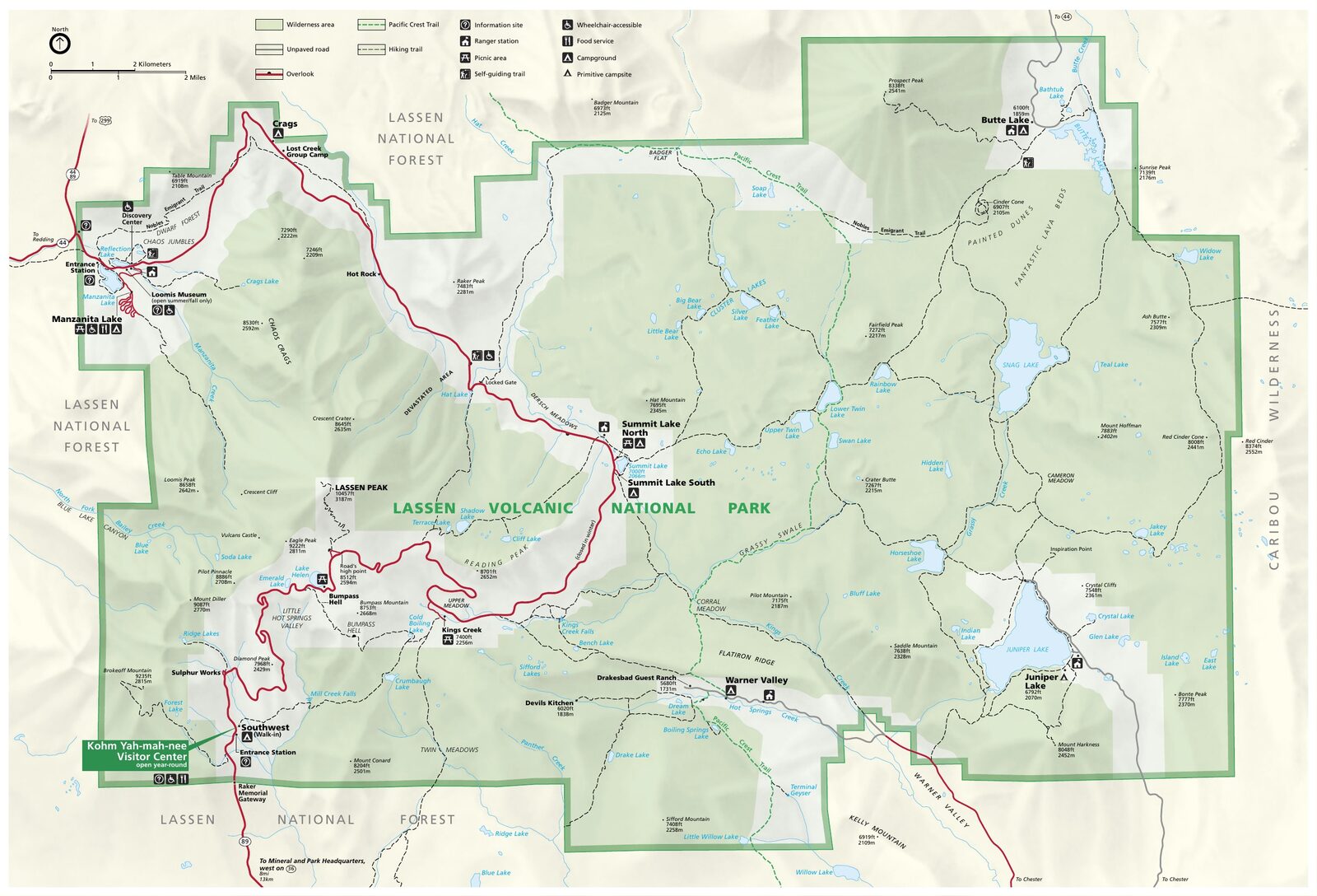
The official park map handed out at entrance stations, with roads, areas, visitor centers and services. View it here or download it for offline use.
Download the map (PDF) Public domain · National Park ServiceWhere Is Lassen Volcanic?
Lassen Volcanic lies in Northern California, near the borders of Shasta and Plumas counties. On a map of the United States, look toward the state's northeastern corner. The park sits in the Cascade Range, about 50 miles southeast of Redding and 175 miles north of Sacramento. Mount Shasta rises to the north, while the Great Basin begins a few dozen miles to the east. This transition zone, between the wet forests of the west and the dry interior basin, explains the variety of landscapes within the park itself. Our guide to the Shasta Cascade region covers the wider area.
Download the Official Lassen Volcanic Map (NPS Unigrid)
The National Park Service's Unigrid map is the best reference for planning your visit. It shows the two main entrances, campgrounds, hydrothermal areas, marked trails, and backcountry roads. The NPS keeps it up to date, and you can download the PDF for free at nps.gov/lavo under “Maps.” Each fee entrance also provides a paper copy with your entrance ticket.
Here's a practical tip: download the map and save it for offline use before you arrive. Cell service is almost nonexistent inside the park.
Lassen Volcanic Areas
Highway 89 crosses the park from north to south for about 31 miles and serves both main entrances. Three backcountry areas lie away from this main route. Together, they make up the park's four distinct areas.
The Northwest Corridor: Main Entrance Area
The north entrance, in the Manzanita Lake area, is reached from Redding via Highway 44 and Highway 89. It's the busiest gateway, with Manzanita Lake Campground, the park's largest campground, a seasonal visitor center, and a particularly photogenic view of Lassen Peak reflected in the lake at dawn. This area is also the first to reopen in spring after the winter snow.
The Central Volcanic Area: Geological Heart of the Park
As you head south on Highway 89, you'll enter the park's most spectacular area. Lake Helen, still covered in snow at high elevation in July, the Lassen Peak Trailhead at the foot of the 10,456-foot peak, and the Devastated Area, marked by the scar of the 1915 lava flow, follow one another over roughly 6 miles. This is also the area most prone to winter closures.
The Southwest Area: Open Year-Round
The south entrance is home to the Kohm Yah-mah-nee Visitor Center, which is open year-round. Nearby, Sulphur Works offers a first look at the park's geothermal activity, including fumaroles and acidic mud pots, in less than a five-minute walk from the parking lot. When the main road is closed by snow, this area remains the only open entrance.
The Backcountry: Warner Valley, Juniper Lake, and Butte Lake
These three wilderness areas are connected by unpaved roads reserved for suitable vehicles. Boiling Springs Lake in Warner Valley, quiet Juniper Lake surrounded by forest, and the Fantastic Lava Beds at Butte Lake offer complete solitude, far from the activity along Highway 89. Check the Unigrid map and road conditions before heading out.
Park Entrances and the Drive Across the Park
Lassen Volcanic has two entrances on Highway 89, both accessible from Interstate 5.
North entrance: From I-5 near Redding, take Highway 44 east for 48 miles to the Highway 89 junction, then continue 1 mile south.
South entrance: From I-5 near Red Bluff, take Highway 36 E for 51 miles to the Highway 89 junction, then continue north.
The full drive across the park on Highway 89 covers about 31 miles. Without stops, allow about an hour of driving. The speed limit is 28 mph in most areas. With essential stops such as Bumpass Hell, Lake Helen, and Sulphur Works, plan on a half day. The main road closes every winter, generally from November through late May, depending on snow conditions. The page on road conditions and off-season access to Lassen Volcanic has the details.
Points of Interest and Viewpoints on the Map
These five sites are marked on the Unigrid map and provide the backbone for a day in the park.
- Bumpass Hell (central area, Highway 89): the park's largest hydrothermal area. Reach it on a 1.5-mile trail from the parking lot on Highway 89. Fumaroles, turquoise acidic pools, and the smell of sulfur await.
- Lassen Peak Trail (central area): a 5-mile round-trip hike from Highway 89 to the 10,456-foot summit. On clear days, it offers wide-open views of the Cascade Range.
- Manzanita Lake (northwest): a classic reflection of Lassen Peak in the water, best photographed at dawn.
- Sulphur Works (southwest): fumaroles and bubbling mud two minutes from the south entrance parking lot.
- Devastated Area (central area): the site of the 1915 lava flow, with toppled trees still standing and on-site interpretation.
For details about activities at each site, the Lassen Volcanic activities guide organizes them by type and duration.
Nearest Towns and Airports
Redding, California, is the gateway town. It's 48 miles from the north entrance and has hotels, supermarkets, gas stations, and Redding Municipal Airport (RDD), which offers domestic flights. For international connections or a wider choice of flights, Sacramento (SMF) is about a three-hour drive south. Our Access & Transportation page covers distances and rental-car options from each airport.
Hiking Maps and Topographic Guides (Paper)
The Unigrid map is enough for a standard visit. For backcountry outings or hikes beyond marked trails, a large-scale topographic map, such as the USGS 1:24,000 series, is strongly recommended, especially without cell service. National Geographic Trails Illustrated maps cover the area. You can find them at specialty travel bookstores or directly at the shop in the Kohm Yah-mah-nee Visitor Center.
Frequently Asked Questions
Are there active volcanoes at Lassen?
Yes. Lassen Volcanic is home to active volcanoes. Lassen Peak last had a major eruption in 1915. The park remains under constant geological monitoring, and its daily hydrothermal activity, including fumaroles, acidic springs, and mud pots, is living proof.
What is the closest town to Lassen Volcanic National Park?
The closest town to Lassen Volcanic is Redding, California, about 48 miles from the north entrance via Highways 44 and 89.
How long does it take to drive across Lassen Volcanic?
The drive on Highway 89 from one entrance to the other takes about an hour without stops. With the main sites, allow a half day. For a structured one- or two-day itinerary, the Lassen Volcanic one- or two-day itinerary offers several formats.
Are there grizzly bears in Lassen National Park?
No. Grizzlies no longer live in California. Lassen Volcanic is home to American black bears (Ursus americanus). Here's the key safety rule: store all food in the bear-proof lockers provided in parking areas and campgrounds, and keep at least 165 feet away if you see a bear. Our Lassen Volcanic wildlife guide covers all the safety guidelines.