
Katmai Map: Layout, Areas, and the Official Map to Download
Katmai National Park and Preserve lies in Alaska's Alaska Peninsula, about 290 miles southwest of Anchorage. The park is accessible only by air. No road leads there from outside. You can download the NPS's official Unigrid map for free at nps.gov/katm/planyourvisit/maps.htm. Print it before you leave. Cell service is nonexistent across almost the entire park.
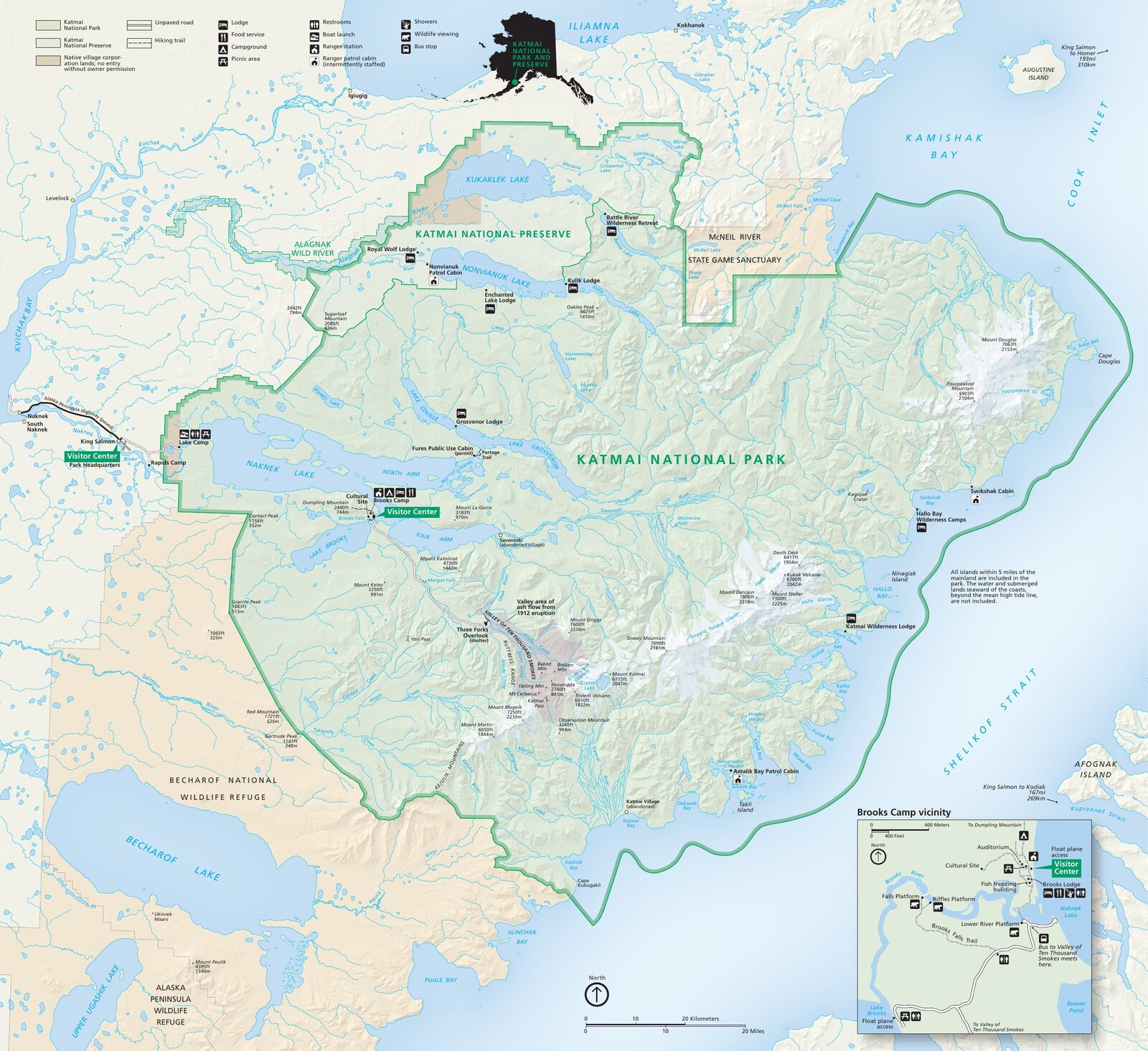
The official park map handed out at entrance stations, with roads, areas, visitor centers and services. View it here or download it for offline use.
Download the map (PDF) Public domain · National Park ServiceWhere Is Katmai?
Katmai sits in the state of Alaska (AK) on the Alaska Peninsula, between the North Pacific Ocean to the south and the Bering Sea to the northwest. Its position between two bodies of water explains its reputation for unpredictable weather. Frontal systems clash here constantly. See the Katmai weather guide for more details.
The park headquarters is in King Salmon, about 290 miles southwest of Anchorage. Kodiak Island lies to the southeast, while Homer is northeast, beyond Cook Inlet. The park covers about 6,200 square miles, more than the area of Belgium. On a map of the United States, it is a remote landscape of volcanoes and lakes, far from any road corridor.
Download Katmai's Official Unigrid NPS Map
The Unigrid map published by the National Park Service is the basic reference for planning your visit. It covers the entire park, including Brooks Camp, the Valley of Ten Thousand Smokes, the Naknek lake system, camping areas, and the main trails.
Download: nps.gov/katm/planyourvisit/maps.htm. It's a free PDF.
The Unigrid map gives you an overview of the landscape. It isn't detailed enough for backcountry hiking. You'll need a 1:63,360 or 1:100,000 topographic map instead. See the "Hiking Maps" section below.
Katmai's Main Areas
Katmai doesn't divide its territory into strict administrative zones. Three geographic areas shape most visits.
Brooks Camp and the Naknek Lakes
This is the park's only developed area and where nearly all visitors arrive. You'll find the visitor center, campground, and, above all, Brooks Falls, where dozens of brown bears fish for sockeye salmon every July. The area centers on Naknek Lake, the park's largest body of water, which you can reach by kayak from camp.
The Valley of Ten Thousand Smokes
About 40 miles from Brooks Camp along the park's only internal road, this valley still bears the scars of the 1912 Novarupta eruption, one of the most powerful of the 20th century. The former glacial valley is covered by a thick layer of ignimbrite. The landscape is stark and dramatic, and far less visited than Brooks Camp.
The Backcountry and the Shelikof Coast
The rest of the park, which accounts for the vast majority of its area, is wild backcountry. You'll find several active volcanoes, including Mount Katmai and Mount Griggs, spruce forests, and a remarkable coastline along Shelikof Strait, with bays such as Hallo Bay and Geographic Harbor. Access is by chartered aircraft or sea kayak only, with no infrastructure. The Katmai hiking guide covers options for self-guided outings.
Park Entrances and Internal Access
Katmai has no road entrances. It's one of the few U.S. national parks accessible only by air. Fly to King Salmon (AKN airport), then take a floatplane or chartered aircraft to Brooks Camp, about a 15-minute flight.
Once you're there, the park has only one travel route: the unpaved road connecting Brooks Camp with the Valley of Ten Thousand Smokes, about 40 miles long. A shuttle service, by bus or van, runs along it in July and August. There are no vehicle loops or east-west crossing routes. The Katmai access and transportation guide has the logistical details, airlines, and prices.
Points of Interest on the Map
Mark these spots on your map before you leave:
- Brooks Falls: An observation platform 20 minutes on foot from camp, and the park's essential bear-viewing spot.
- Naknek Lake: The central body of water and the starting point for kayaking trips.
- Valley of Ten Thousand Smokes: The shuttle's terminus and access point for volcanic trails.
- Hallo Bay: On the Shelikof coast, accessible by charter only. Bears feed on the tidal flats here.
- Geographic Harbor: A place to watch marine wildlife from a boat.
For a detailed itinerary around these sites, see the What to Do in Katmai guide or the complete park guide.
Nearest Towns and Airports
| Town / airport | Distance | Role |
|---|---|---|
| King Salmon (AKN) | ~15-minute flight from Brooks Camp | Main gateway |
| Anchorage (ANC) | ~290 miles | Main hub from the mainland |
| Homer | ~186 miles | Secondary access, charter flights |
| Kodiak | ~124 miles | Charter alternative |
King Salmon is the only town with convenient direct access to the park. Anchorage remains the logistical hub for visitors arriving from Europe or elsewhere in the United States. The Katmai access and transportation guide details routes, schedules, and prices.
Paper Hiking Maps and Topographic Guides
For Katmai's backcountry, a paper topographic map isn't a luxury. Two references stand out:
- National Geographic Trails Illustrated No. 248, Katmai National Park: The go-to map for visiting the park, available from Cartovia and specialty travel bookstores. It covers the entire park and identifies trails and campgrounds.
- USGS 1:63,360 maps: Federal topographic maps that are essential for any backcountry travel. Several sheets cover the park. Identify the right quadrangles for your area before ordering.
Frequently Asked Questions
How do you get to Katmai?
To reach Katmai, first fly to King Salmon from Anchorage on a commercial flight, then take a floatplane or chartered aircraft to Brooks Camp. No road leads to the park. The Katmai access and transportation guide walks you through each step.
What is the history of Katmai National Park?
Katmai National Park's history is inseparable from the June 6, 1912, eruption of Novarupta, one of the most violent eruptions of the 20th century. The national monument was established in 1918 to protect this exceptional volcanic landscape, then redesignated as a national park in 1980.
Is there a Katmai map, and can you download it?
Yes. You can download the NPS's official Unigrid map for free at nps.gov/katm/planyourvisit/maps.htm. For backcountry hiking, pair it with National Geographic Trails Illustrated No. 248 or USGS 1:63,360 maps.
Can you drive across Katmai?
No. Katmai has no road access from outside. An unpaved road connects Brooks Camp with the Valley of Ten Thousand Smokes, about 40 miles away, and a shuttle runs in summer. You can't cross the entire park in a private vehicle.
What's the best viewpoint in Katmai?
Brooks Falls is the most popular viewpoint, with dozens of brown bears visible from the walkways in July. For volcanic scenery, the edge of the Valley of Ten Thousand Smokes offers a striking view of the caldera. The What to Do in Katmai guide lists other spots depending on the season.
What's the nearest town to Katmai?
The nearest town to Katmai is King Salmon, about a 15-minute flight from Brooks Camp. It's the only convenient access point to the park. Anchorage, about 290 miles northeast, is the main logistics hub for visitors traveling from farther away.
How long does it take to visit Katmai?
Two to three days is enough to explore the Brooks Camp area and watch the bears. You'll need a week or more to explore the backcountry. The Katmai itinerary guide offers specific plans based on how much time you have.