
Glacier Bay Map: Park Areas, Official Map, and What to Download
Glacier Bay National Park lies in southeastern Alaska, about 81 miles west of Juneau. You can't reach the park by road or train, only by plane or boat. The official Unigrid map is available as a free PDF on the NPS website, and you can pick up a paper copy at the Bartlett Cove visitor center.
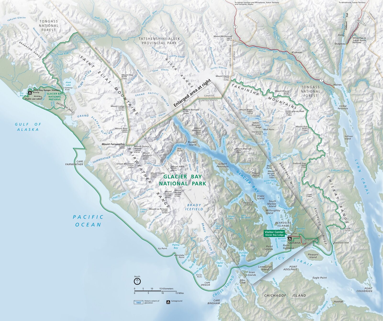
The official park map handed out at entrance stations, with roads, areas, visitor centers and services. View it here or download it for offline use.
Download the map (PDF) Public domain · National Park ServiceWhere Is Glacier Bay?
Glacier Bay National Park and Preserve stretches across Alaska's Panhandle, the strip of coast in the southeast wedged between the Fairweather Range to the west and the Canadian border with British Columbia to the east. On a map of the United States, find Alaska and follow the Pacific coast north. Glacier Bay sits in the finger of land along Canada, halfway between Skagway and Yakutat.
The bay itself is a Y-shaped fjord turned upside down. Two arms reach more than 62 miles inland toward the ice fields: West Arm to the west and Muir Inlet to the east. Two hundred and fifty years ago, all this water lay beneath the ice. The retreat documented since then is among the fastest ever recorded anywhere in the world. Our Region guide puts Glacier Bay in the broader context of southeastern Alaska.
Download the Official Glacier Bay Map (NPS Unigrid)
The National Park Service publishes a free Unigrid map as a PDF on nps.gov/glba, under the “Maps” tab. It covers the entire park and preserve, including named glaciers, the bay's bathymetry, regulated boating areas, and preserve boundaries.
At the Bartlett Cove visitor center, on the second floor of Glacier Bay Lodge, rangers hand out paper copies. If you're arriving by cruise ship, pick one up before departure. It will help you follow the ship's progress from glacier to glacier and make sense of the captain's announcements from the deck.
Glacier Bay's Areas
Bartlett Cove and the Bay Entrance
Bartlett Cove is the only part of the park you can reach by car. You'll find Glacier Bay Lodge, the campground, the dock for boat excursions, and two land trails: Forest Trail, a short loop through conifer forest, and the Bartlett River Trail. The visitor center and ranger station are here too. This is where every visit begins.
West Arm (Western Arm)
This is the busiest arm and the one used by cruise ships. Boats travel up the arm to the Margerie and Grand Pacific glaciers, side by side at its far end. Margerie Glacier is the most active. Its vertical face rises 69 feet above the water and regularly calves spectacular chunks of ice. Johns Hopkins Inlet, a tributary of West Arm, is home to several active glaciers and a harbor seal colony that gives birth there. Boats must keep their regulated distance from May 1 through June 30.
Muir Inlet (Eastern Arm)
Wilder and far less traveled, Muir Inlet is home to Muir Glacier. Its face has retreated several dozen miles since John Muir described it in the late 19th century. It remains a signature destination for sea kayaking and expedition camping. No regular cruises enter this arm. This is self-sufficient paddler and ranger country.
The Preserve
The park's northeastern section is designated as preserve, a federal status that allows hunting under certain conditions. Almost inaccessible without an air taxi or a long expedition, it appears on the official map to clarify use rights in each area.
Park Entrances and Getting Around
Glacier Bay has no entrance gates. The only drivable road, about 10 miles long, connects Gustavus Airport with park headquarters at Bartlett Cove. It ends there. You can't cross Glacier Bay by car. All travel inside the park happens by boat, either on a guided excursion or in a kayak, or by floatplane.
Speed limits on the Gustavus–Bartlett Cove road are clearly posted and must be followed carefully. Wildlife, especially bears, regularly crosses the road. For flight and ferry options from Juneau, see the Glacier Bay access guide.
Points of Interest and Viewpoints on the Map
Glacier Bay's “viewpoints” aren't land-based overlooks. You see them from a boat deck or a kayak cockpit:
- Margerie Glacier: An active glacier in West Arm and the highlight of day cruises. You can hear its calving from several hundred yards away.
- Grand Pacific Glacier: The largest tidewater glacier in the park. Its terminus now straddles the U.S.–Canada border.
- Johns Hopkins Inlet: A harbor seal breeding site surrounded by constantly active glaciers.
- Point Gustavus: South of the bay, a seasonal humpback whale-watching spot from June through August.
The Glacier Bay activities guide and the park wildlife page locate and describe each of these sites in detail.
Nearest Towns and Airports
The nearest town to Glacier Bay is Gustavus, 10 miles from park headquarters. It's a village of fewer than 500 people, with a few places to stay, a grocery store, and an airport (IATA code: GST) with seasonal service from Juneau. The flight takes about 20 minutes.
Juneau (code JNU) is the main gateway from outside Alaska. From elsewhere in the United States, travelers generally connect through Seattle (SEA) or Anchorage (ANC) before continuing to Juneau. Our Access & Transportation page and our complete Glacier Bay guide cover the options and compare prices.
Hiking Maps and Printed Trail Guides
Glacier Bay's land trails can be counted on one hand. For kayakers heading out independently for several days, a detailed topographic map is essential. You'll need to read the underwater terrain, find authorized campsites, and identify regulated areas.
The National Geographic Trails Illustrated Map No. 255 (Glacier Bay National Park) is the standard reference. It includes official place names, bathymetry, and restricted areas. You can find it at specialty retailers (cartovia.com) and at the Bartlett Cove visitor center.
Frequently Asked Questions
What is the nearest town to Glacier Bay?
The nearest town to Glacier Bay National Park is Gustavus, about 10 miles from park headquarters at Bartlett Cove. Gustavus has an airport (GST) with daily flights from Juneau during the season.
What does Glacier Bay look like?
Glacier Bay looks like a Y-shaped fjord carved into Alaska's Panhandle. Two arms, West Arm and Muir Inlet, reach toward ice fields framed by peaks rising above 14,800 feet. There are no beaches and no forests you can reach by car. Most of the spectacle unfolds from the water.
What can you do at Glacier Bay National Park?
You can take a day cruise from Bartlett Cove to get close to active glaciers, spend several days sea kayaking on Muir Inlet, hike the land trails around Bartlett Cove, or watch whales from Point Gustavus. Our Things to Do page and the Glacier Bay hiking guide cover each option.
Which glacier is the most famous in Glacier Bay?
Margerie Glacier is the park's most visited glacier. Its active vertical face in West Arm regularly calves chunks of ice and is the high point of day cruises. Grand Pacific Glacier is larger but less accessible, making it the other must-see in this area.