

Congaree Map: Layout, Areas, and Official Map Download
Congaree National Park is in South Carolina, about 25 miles southeast of Columbia. The park protects the largest tract of old-growth temperate bottomland forest in the United States, recognized as a UNESCO biosphere reserve in 1983. Its official map (a free PDF at nps.gov/cong) fits on a single sheet. The trail network is short, navigation is straightforward, and most of the park can be explored on foot from the only entrance.
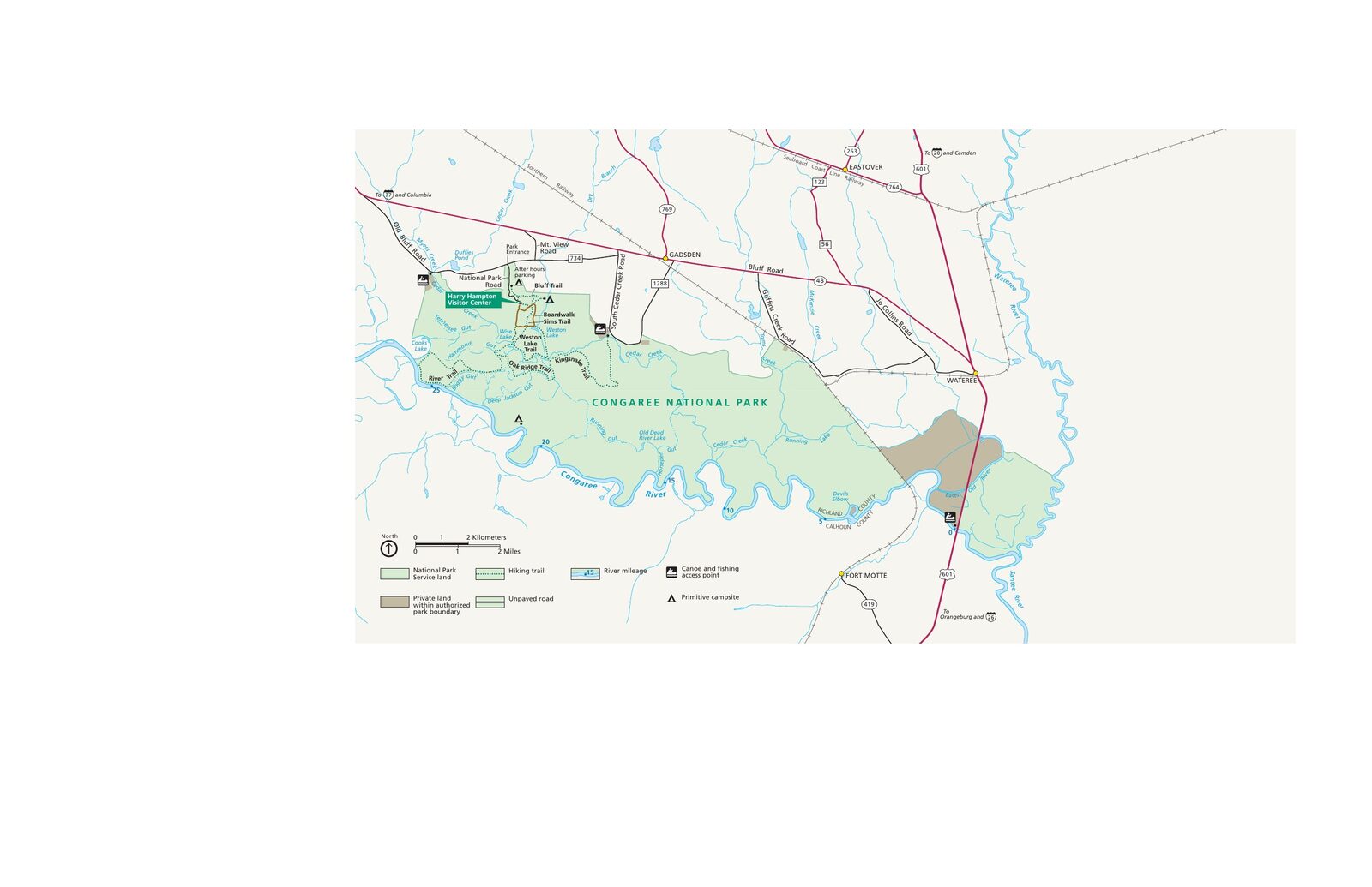
The official park map handed out at entrance stations, with roads, areas, visitor centers and services. View it here or download it for offline use.
Download the map (PDF) Public domain · National Park ServiceWhere Is Congaree?
Congaree is in the southeastern United States, in South Carolina (SC), in the inland coastal plain known as the Midlands. The park spans Richland and Calhoun counties, about 25 miles southeast of Columbia, the state capital.
On a map of the United States, Congaree sits between the Appalachian Mountains to the west and the Atlantic coast to the east. Two useful reference points are Charlotte, North Carolina, about a 3-hour drive to the north, and Savannah, Georgia, 2.5 hours to the southwest. The park's geography is defined entirely by its floodplain. The Congaree River forms its southern boundary, and Cedar Creek runs through it from west to east.
For transportation logistics, the Congaree access guide covers routes from major cities and airports.
Downloading the Official Congaree Map (NPS Unigrid)
The NPS publishes the official high-resolution map as a free PDF on its website (nps.gov/cong, under "Maps"). It's the definitive reference. It shows all the trails, water sources, primitive camping areas, and flood-prone zones to watch.
The paper version is available at the Harry Hampton Visitor Center, which is open from 9 a.m. to 5 p.m. Here's a practical tip: download the PDF before you leave. Cell service is often unavailable under the dense canopy.
Another thing to keep in mind is that heavy rain can cause Cedar Creek and the Congaree River to rise very quickly. Alert bulletins are posted at the visitor center and available in real time on the NPS website.
Congaree Areas
Congaree is a compact park of about 107 square miles, accessible through a single entrance. The park is divided into three functional areas based on how you plan to visit.
Visitor Area and Boardwalk
The Harry Hampton Visitor Center is where you'll find the entrance, parking lot, and trailheads for marked trails. This is where the Boardwalk Loop begins, the park's signature boardwalk, which covers about 2.5 miles round-trip. The northwest area is the busiest and best equipped.
Interior Forest and Woodland Trails
Beyond the boardwalk, the trails lead deeper into the old-growth forest. This is where you'll find the "champion trees," including bald cypresses and tulip trees that sometimes rise more than 164 feet, among the tallest of their species in the United States. Navigation is more demanding here, so bring the paper map and a compass.
Cedar Creek Floodplain (Canoeing and Kayaking)
Cedar Creek runs through the park along a navigable route, accessible from launch points shown on the official map. This water corridor is separate from the hiking trail network. You can't reach it on foot from the Visitor Center. Our Things to Do in Congaree page covers boating conditions and distances.
Park Entrances and Getting Around by Car
Congaree has just one road entrance.
Unlike many American national parks, you can't drive through Congaree. The road ends at the parking lot, and there is no scenic driving loop inside the park. You can explore only on foot or by canoe on Cedar Creek. The park is open 24/7 year-round. For parking and transportation options from Columbia, see Getting Around Congaree.
Points of Interest to Find on the Map
The NPS map identifies the following features, all accessible from marked trails.
Weston Lake is an oxbow lake, an isolated bend in the river, in the interior forest. You can reach it via the Weston Lake Loop. It's a quiet spot that's ideal for watching birds and turtles.
The champion trees have approximate GPS coordinates available at the Visitor Center, and some are shown directly on the Unigrid map.
Primitive camping sites are five sites scattered through the forest. You can reach them only on foot, and you'll need a free permit available at the visitor center. For access conditions and reservations, see the Congaree camping guide.
For photography spots and activities in detail, the complete Congaree guide and the Things to Do page cover the highlights by area.
Nearest Cities and Airports
Columbia (SC), about 25 miles to the northeast, is the main service hub. As the state capital, it offers everything you need, including lodging, restaurants, and car rentals. Lodging in Columbia and within 19 miles of the park is listed in the Where to Stay Near Congaree guide.
The nearest airport is Columbia Metropolitan (CAE), about 28 miles from the park. For transportation options from the airport, see the Access & Transportation page.
Paper Hiking Maps and Trail Guides
The NPS Unigrid map is enough for the vast majority of visitors. If you're planning a deeper backcountry exploration or a multi-day canoe trip, a few additional resources are worth checking out.
National Geographic Trails Illustrated offers a topographic map of the region. You can find it at specialty travel bookstores (itm.fr, atlas-des-voyages.fr) or online through mapping platforms.
The Visitor Center sometimes sells trail guides published by local South Carolina organizations. Ask about them when you arrive.
Frequently Asked Questions
Where is Congaree on a map of the United States?
Congaree National Park is in the southeastern United States, in South Carolina, about 25 miles southeast of Columbia, between the Appalachian Mountains and the Atlantic coast.
Is there a map of Congaree, and can I download it for free?
Yes. The official map is available as a free PDF at nps.gov/cong. It's also distributed in paper form at the Harry Hampton Visitor Center.
Can you drive through Congaree?
No. The road ends at the Visitor Center parking lot, and there is no scenic driving loop inside the park. You can visit on foot via marked trails or by canoe or kayak on Cedar Creek.
What's the best place to see in Congaree?
The Boardwalk Loop, which starts at the Visitor Center, is the standard route for a first visit. For the must-see spots and their associated hiking times, our Things to Do in Congaree page has the details.
How long do you need to visit Congaree?
It depends on the activities you choose and your pace. Our Itinerary & Length of Stay page outlines plans for different trip lengths.
What is the closest city to Congaree?
The closest city with full services is Columbia, South Carolina, about 25 miles northeast of the park.