
Zion Map: Layout, Districts, and Official Map to Download
Zion National Park lies in southwestern Utah, about 168 miles north of Las Vegas. The park covers roughly 229 square miles of red sandstone canyons and mesas. The official map published by the NPS, known as the “Unigrid,” is available as a free download from the National Park Service website and remains the essential reference for planning your visit. You’ll find it at the bottom of this page.
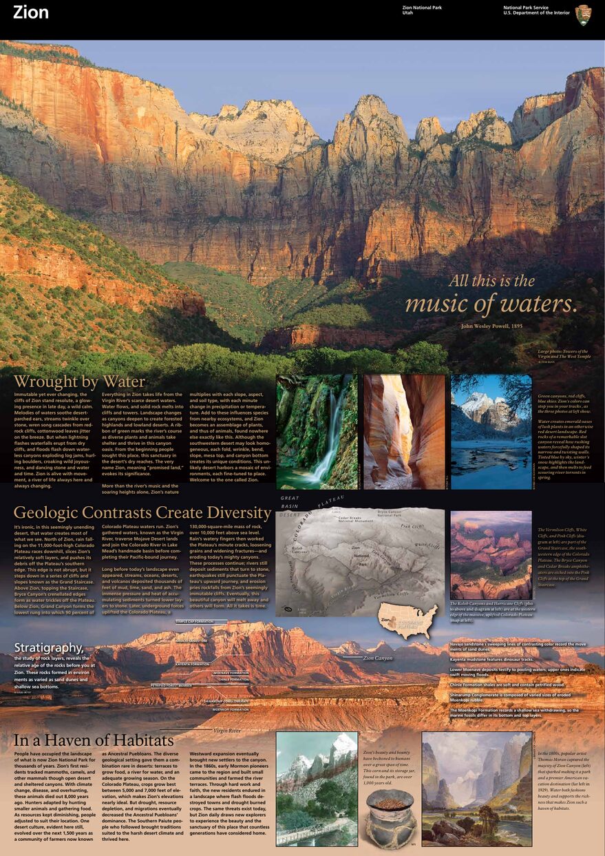
The official park map handed out at entrance stations, with roads, areas, visitor centers and services. View it here or download it for offline use.
Download the map (PDF) Public domain · National Park ServiceWhere Is Zion Located?
Zion sits in Washington County, in the far southwestern corner of Utah, along the edge of the Colorado Plateau. The closest town is Springdale, right up against the park’s main southern entrance. Las Vegas is about a 2.5-hour drive away (162 miles). St. George, 40 miles west, is the most convenient regional hub for services. Salt Lake City is about 4.5 hours away.
The park is part of the “Grand Circle,” a concentration of national parks across the American West. Visitors often combine Zion with Bryce Canyon (56 miles to the northeast) on the same Utah road trip.
Zion’s Official Map (NPS Unigrid) to Download
For each park, the NPS publishes a folded paper map known as the “Unigrid,” distributed free at the entrances. Its PDF version is available on the official website and covers the entire park, roads, main trails, campgrounds, and service facilities.
For use in the park, download it before you leave. Cell service in the canyon is unreliable, and no online map can replace this document once you’re in the canyon. It’s in English, but the icons are easy to understand.
The NPS also offers specific trail maps for The Narrows and Angels Landing at the Visitor Centers.
Zion’s Districts
Zion isn’t one uniform park. It’s divided into three distinct areas, each with its own character.
Zion Canyon (Main District, South Entrance)
This is the heart of the park, the canyon everyone pictures. Zion Canyon Scenic Drive follows the Virgin River for about 6.2 miles from the Visitor Center to Temple of Sinawava. Most of the iconic trailheads, including Angels Landing, Emerald Pools, and The Narrows, are here. During the busy season, from March through November, personal vehicles aren’t allowed on this road. You can reach it only by the park’s free shuttles.
Kolob Terrace Road (Central District)
Accessible from the small town of Virgin to the west, this road climbs onto Kolob Terrace at about 6,560 feet. It sees fewer visitors and leads to Lava Point Overlook and several trailheads for longer hikes. In winter, the road may close depending on snow conditions.
Kolob Canyons (Northwest District)
This separate entrance is accessible from I-15 at Exit 40, 37 miles from the main canyon. Kolob Canyons Road, which is 5 miles long, leads to overlooks of red-walled finger canyons. Visitors in a hurry often skip this area, making it a good choice for a quiet morning.
Park Entrances and Internal Roads
Zion has two main fee-paying entrances.
South Entrance (Main): Near Springdale on UT-9. This is the entrance to the Zion Canyon Visitor Center and the entire Zion Canyon Scenic Drive. Lines form here during the busy season, especially early in the morning.
East Entrance: Also on UT-9, near Checkerboard Mesa, beyond the Zion-Mount Carmel Tunnel, which runs about 1.1 miles through the rock. Vehicles taller than 13 feet or wider than 8 feet require a paid ranger escort through the tunnel. Check your RV or van’s dimensions before you arrive.
Kolob Canyons Entrance: On I-15 in the northwest district, completely separate from the other two.
Zion Canyon Scenic Drive is accessible only by shuttle from March through November. Outside that period, you can drive your personal vehicle there. For transportation from Springdale and parking in the canyon, the Zion access guide covers all the options.
Key Landmarks on the Map
Here are the landmarks to locate on your map before you set out.
Angels Landing: Rising to 5,784 feet, this rocky promontory at the end of the canyon is probably the park’s most recognizable photo spot. A permit is now required to access the chains on the final section, issued through a lottery. The Zion hiking guide covers the permit details.
The Narrows: The lower section of the Virgin River, where the canyon narrows to just a few yards across. You walk in the water. Starting point: Temple of Sinawava, the last shuttle stop.
Emerald Pools: Three levels of pools and waterfalls, reached by trails of increasing difficulty from Zion Lodge.
Checkerboard Mesa: A checkerboard-patterned rock formation near the east entrance, visible from UT-9 without leaving your car.
Canyon Overlook: A short, 0.5-mile round-trip trail just beyond the east tunnel that offers a first view of the main canyon. It’s ideal if you arrive from the east and want an introduction before reaching the Visitor Center.
For a complete itinerary, our Things to Do page lists activities by district.
Nearest Towns
Springdale is the natural base for logistics. Lodging, restaurants, and the shuttle from town to the Visitor Center all start there. Our Where to Stay page reviews the options.
St. George is 40 miles west, Las Vegas is 162 miles south, and Salt Lake City is about 4.5 hours north. To plan your visit, the Zion access guide details the options from each of these cities.
Hiking Maps and Paper Guidebooks
The Unigrid map is enough to get around the park, but it doesn’t show contour lines in detail or trail variations. For challenging hikes such as West Rim Trail, The Subway, and Trans-Zion, we recommend National Geographic’s Trails Illustrated maps (Utah series, reference #214 Zion National Park), available at specialty travel bookstores or on the NPS website. Some Visitor Centers carry them. Arrive early because supplies are limited during the busy season.
Frequently Asked Questions
Can you drive across Zion?
Yes. UT-9 crosses the park from west to east through the Zion-Mount Carmel Tunnel, so you can drive across the park. However, Zion Canyon Scenic Drive, the main canyon north of the Visitor Center, is closed to personal vehicles from March through November. Only the NPS’s free shuttles run there during that period.
How much does it cost to enter Zion National Park?
The fee is $35 per private vehicle, valid for 7 days. Motorcycle entry costs $30, and entry for visitors on foot or by bicycle costs $20 per person. The America the Beautiful pass ($80 per year) covers admission to all U.S. national parks and is a good investment once you visit two parks. For entrance fees and annual passes, see the National Park Entrance Fees & Passes page.
How much time do you need to visit Zion?
Two days are enough to cover the main canyon and iconic trails. Three days give you time to add Kolob Canyons or a trip to Bryce Canyon. Our Itinerary & Length of Stay page offers day-by-day plans.
What’s the best viewpoint in Zion?
Canyon Overlook is the most accessible, a 15-minute walk from the parking area beyond the tunnel. Angels Landing offers the most spectacular panorama, but the chains section requires a permit. Our Things to Do page compares the viewpoints by difficulty and recommended time of day.
What’s the closest town to Zion?
Springdale, Utah, sits right next to the park’s main southern entrance. That’s where you’ll find the hotels, restaurants, and shuttle departure points for the Visitor Center.