

Saguaro Map: Districts, Roads, and the Official Map
Saguaro National Park lies on both sides of Tucson, Arizona. Its distinctive layout is easy to see on a map: two districts separated by the city itself, each with its own entrance, scenic drive, and character. The official NPS map is a free PDF available at nps.gov/sagu under “Maps.” You’ll find all the practical information in our complete Saguaro guide.
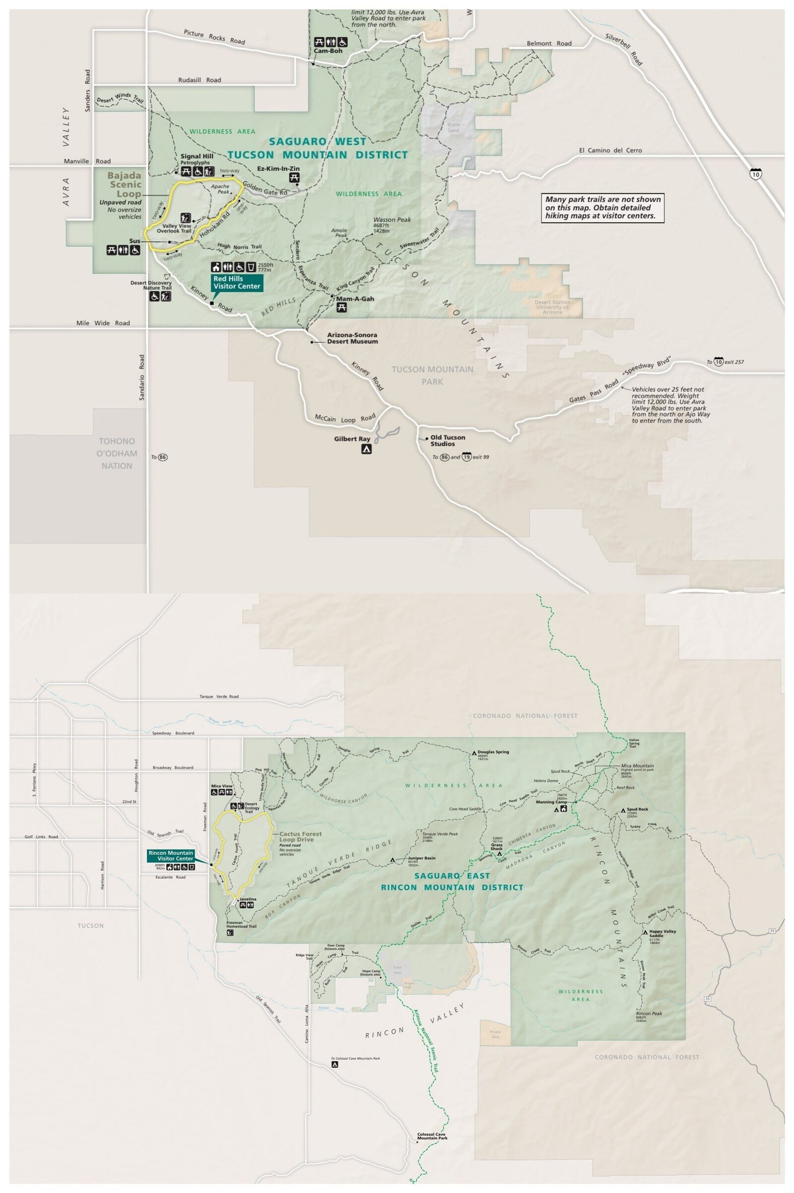
The official park map handed out at entrance stations, with roads, areas, visitor centers and services. View it here or download it for offline use.
Download the map (PDF) Public domain · National Park ServiceWhere Is Saguaro Located?
Saguaro National Park is in Pima County, in southern Arizona. The two districts flank Tucson: the East District borders the Rincon Mountains east of the city, while the West District runs along the Tucson Mountains to the west.
On a U.S. map, the park sits in the arid Southwest, about 175 miles southeast of Phoenix and 62 miles north of the Mexican border. This location puts Saguaro in the heart of the Sonoran Desert, one of the few deserts in the world warm and wet enough for giant saguaros, which can grow up to 39 feet tall.
To place Saguaro among the parks of the Southwest, the Regions section provides an overview of the arid parks of the wider Southwest.
Download Saguaro’s Official NPS Unigrid Map
The National Park Service provides Saguaro’s Unigrid map free of charge. This PDF includes:
- detailed maps of both districts, including roads, major trails, picnic areas, and visitor centers;
- a simplified topographic background;
- distances in miles between the main stopping points.
Download it from nps.gov/sagu before you leave. Cell service inside the districts is unreliable. The map prints properly on A4 or letter-size paper. Keeping a paper copy in the glove compartment is still the best backup.
Saguaro’s Two Districts
Saguaro is not one continuous park. Each district has its own geography and is best explored independently.
West District: Tucson Mountain District
This area is the easiest to reach from downtown Tucson. Bajada Loop Drive, an 8.1-mile scenic loop that is partly gravel, forms the district’s main road. Saguaros are especially dense here, covering the hillsides as far as you can see. You’ll also find the Hohokam petroglyphs at Signal Hill and the Red Hills Visitor Center. Entrance address: 2,700 N Kinney Rd.
East District: Rincon Mountain District
This larger district climbs to the summit of Mica Mountain at 8,665 feet. Cactus Forest Loop Drive is a fully paved, one-way 8.1-mile loop open to cars. Beyond it, the terrain becomes mountainous. The high-elevation trails are for well-equipped hikers, with overnight backcountry trips. Rincon Mountain Visitor Center is at the park’s east entrance.
Park Entrances and Internal Roads
The two districts aren’t connected by a direct road. To get from one to the other, you’ll need to drive back through Tucson, which takes 30 to 40 minutes depending on city traffic.
Inside each district, the speed limit is 25 mph. That’s worth knowing before you plan your day.
- West District: Bajada Loop Drive, an 8.1-mile loop with an unpaved section. Regular vehicles can use it in dry weather.
- East District: Cactus Forest Loop Drive, a fully paved, one-way 8.1-mile loop.
The park is open to pedestrians and cyclists 24 hours a day. Visitor centers are open from 9 a.m. to 5 p.m. October through May, then from 8 a.m. to 4 p.m. June through September.
Entrance fees are $25 per vehicle, $20 per motorcycle, and $15 per person on foot or by bicycle. The annual park pass costs $45.
For access roads from Phoenix and car rentals in Tucson, see the guide to getting to Saguaro.
Map Highlights
These sites are marked directly on the NPS Unigrid map.
- Signal Hill (West District): a Hohokam Native American petroglyph site, a 10-minute walk from the parking area. It’s marked on the map with the NPS historic site symbol.
- Valley View Overlook (West District): a viewpoint over the saguaro forest, especially striking in the late afternoon when the low light turns the cacti golden.
- Cactus Forest Loop (East District): the go-to loop for seeing giant saguaros at eye level, from the car or on foot.
- Mica Mountain (East District): the park’s highest point at 8,665 feet, reserved for hikers camping in the backcountry.
Each of these spots appears on the Unigrid map with its NPS symbol. For the must-do activities, see the Saguaro things to do guide; for our trail picks, see the Saguaro hiking guide.
Nearest Cities and Airports
Tucson is the natural base for exploring the park and physically separates the two districts. Tucson International Airport (TUS) is about 12 miles from the East District.
Phoenix Sky Harbor (PHX) is a 2.5- to 3-hour drive from Tucson and offers more nonstop connections from Europe.
For places to stay in Tucson or near the park, the Saguaro lodging guide lays out options by budget and district.
Hiking Maps and Topographic Guides
The NPS Unigrid map does a good job covering roads and short trails. For longer hikes in the East District, including Mica Mountain and Rincon Peak, a paper topographic map is strongly recommended.
- Trails Illustrated (National Geographic), reference #237: a 1:35,000-scale map of the park, available at specialty bookstores and outdoor retailers.
- Travel bookstores also carry Benchmark Maps of Arizona for a broader regional view.
Always check the publication date. Some trails in the East District have changed in recent years.
Frequently Asked Questions
Where is Saguaro National Park on a map of the United States?
Saguaro National Park is in Arizona, in Pima County, east and west of Tucson. It lies in the Sonoran Desert in the southern United States, about 175 miles southeast of Phoenix.
Can I download a map of Saguaro?
Yes. The official NPS Unigrid map is available as a free PDF at nps.gov/sagu under “Maps.” It covers both districts, including roads, trails, and points of interest.
Can you drive across Saguaro?
Each district has an approximately 8.1-mile scenic loop. The two districts aren’t connected, so you’ll need to drive back through Tucson, a 30- to 40-minute trip, to get from one to the other.
What’s the best viewpoint in Saguaro?
Valley View Overlook in the West District is one of the most photographed viewpoints, especially late in the day. For the complete list of spots, see our Things to Do page.
How long does it take to visit Saguaro? Half a day is enough to explore one district by car with a few stops. Allow two days for both districts and some hiking.
What’s the closest city to Saguaro?
Tucson is the nearest city and the ideal base. It’s literally between the two districts. Tucson International Airport (TUS) is about 12 miles from the East District entrance.