
Redwood Map: Areas, Access, and the Official Map Download
Redwood National and State Parks stretches along about 62 miles of coastline in far northern California, almost all the way to the Oregon border. US-101 runs north to south through the park, and the official NPS map, known as the Unigrid map, is available as a free download from the National Park Service website.
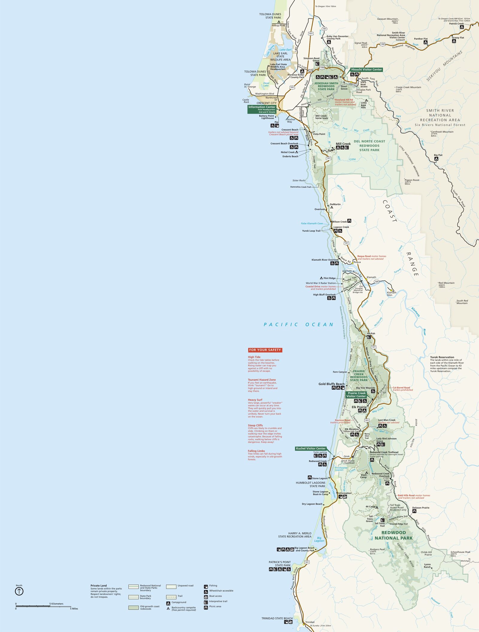
The official park map handed out at entrance stations, with roads, areas, visitor centers and services. View it here or download it for offline use.
Download the map (PDF) Public domain · National Park ServiceWhere Is Redwood?
Redwood lies in Del Norte and Humboldt counties in Northern California, about 325 miles north of San Francisco, or a six- to seven-hour drive. The Oregon border is less than 31 miles north of the park's northernmost entrance.
On a map of the United States, the park sits in the country's northwestern corner, where the Pacific Coast takes on a distinctly rugged, foggy character. Expect dense forests, near-constant fog, and temperatures that rarely rise above 68°F. Don't confuse it with Sequoia National Park, more than 373 miles south in the Sierra Nevada. The trees belong to the same family, but the geography is completely different.
The complex is jointly managed by the National Park Service and the State of California. The official name is Redwood National and State Parks, in the plural, because four distinct units meet along this coastal strip. For seasonal information and current conditions, the Redwood Weather Guide breaks things down month by month. The Redwood Guide puts the park in its regional context and suggests priorities based on your travel style.
Download the Official Redwood Map (NPS Unigrid)
The Unigrid map is the NPS's official reference map. It shows the four units, major roads, trails accessible by car, and picnic areas. It's available as a free PDF on nps.gov.
Visitor centers hand out a paper version at the entrance. Always pick one up. Cell service is almost nonexistent around Prairie Creek and along Newton B. Drury Scenic Parkway.
Redwood's Areas from North to South
The park forms a 62-mile-long vertical strip. Here are its four geographic units, from north to south.
Jedediah Smith Redwoods State Park
This is the northernmost unit, just outside Crescent City. The Smith River runs through it, a wild river with no dams or artificial reservoirs. Howland Hill Road, an unpaved road that standard cars can use in dry weather, passes some of the park's largest trees. There's no cell service, few people, and a true old-growth forest atmosphere.
Del Norte Coast Redwoods State Park
Just south of Jedediah Smith, Del Norte combines the Pacific shoreline with coastal redwoods. The narrow coastal strip creates sharp contrasts. Within a few hundred yards, you can go from beach to century-old forest.
Prairie Creek Redwoods State Park
The central area, and for many visitors the most photogenic. Put two landmarks on your map: Newton B. Drury Scenic Parkway, a 10-mile road completely lined with redwoods and a highly recommended alternative to US-101, and Fern Canyon, a gorge whose 49-foot walls are covered with ferns from top to bottom. I visited one November morning. The silence, the moisture, and the layers of ferns covering every inch of rock made it hard to imagine a more immersive setting. Gold Bluffs Beach, reached via Davison Road, completes the picture with its open meadows facing the Pacific.
Southern Area: Redwood National Park Around Orick
This is the federal unit proper. The Thomas H. Kuchel Visitor Center, the park's largest, is here. Shuttles to Tall Trees Grove leave from this area, where some redwoods rank among the tallest trees ever measured.
Park Entrances and Driving Through Redwood
There is no toll on the main road. US-101 runs north to south through the complex, and nothing stops you from driving straight through without stopping. That said, you'd miss out on 62 miles of exceptional forest.
The roads are open year-round. Speed limits vary by section, especially on Newton B. Drury Scenic Parkway and the unpaved roads. RVs and vehicles with trailers face restrictions on some narrow sections, including Davison Road and Howland Hill Road. Check conditions before you set out. For complete trip logistics, including flights, distances from major cities, and public transportation, the Redwood Access Guide covers all the options.
Points of Interest and Viewpoints on the Map
Here are a few landmarks to locate on your map before you leave.
Lady Bird Johnson Grove: A short loop that's accessible to everyone, on the hills above Orick. It's a good introduction to the redwoods with little noticeable elevation gain.
Fern Canyon: A narrow gorge in Prairie Creek, with walls covered in ferns up to 49 feet high. The ground stays wet year-round. Davison Road, which leads there, may close after heavy rain, so check conditions the day before.
Crescent Beach Overlook: A viewpoint over the Pacific from the hills north of the park. It's one of the few places where redwoods and ocean appear in the same view.
Newton B. Drury Scenic Parkway: Drive the 10 miles early in the morning, when Roosevelt elk occupy the neighboring meadows.
For trail details and distances, see Redwood's Hikes. To plan your schedule around these sites, the Redwood Activities Guide covers the must-see stops.
Nearest Towns and Airports
Crescent City is the closest town to the northern area, including Jedediah Smith and Del Norte, just a few miles from the Oregon border. It's the natural base for exploring the northern parts of the park.
Eureka and Arcata, about 75 miles south of Orick, form the region's main population center, with more lodging and dining options. Arcata-Eureka Airport (ACV) is the gateway by air to the southern area.
For travelers coming from the north, Medford Airport in Oregon, code MFR, is an alternative about a two-hour drive from Crescent City. To find a place to stay near the park, the Where to Stay in Redwood Guide lists options by area.
Hiking Maps and Trail Guides (Print)
The NPS Unigrid map covers the entire park but remains a general map. Hikers who venture beyond the main marked trails can find 1:24,000-scale USGS topographic maps for each area. They're available at visitor centers and from specialty travel booksellers.
The guidebook "Hiking Redwood National and State Parks" from Falcon Guides is the standard print reference for several days of trails. It includes elevation profiles and precise descriptions of junctions, which are useful when signs become scarce in dense forest.
Frequently Asked Questions
Where is Redwood?
Redwood National and State Parks lies in far northern California, about 325 miles north of San Francisco and less than 31 miles from the Oregon border.
What is a redwood?
Redwood refers to the coast redwood (Sequoia sempervirens), the world's tallest plant species by height. Redwood National and State Parks protects the largest remaining forests of coast redwoods, which have been a UNESCO World Heritage Site since 1980.
Can I download the official Redwood map?
Yes. The NPS Unigrid map is available as a free PDF on the National Park Service website. Visitor centers also distribute a paper version at the entrance.
Can you drive through Redwood?
Yes. US-101 crosses the park from north to south for about 62 miles with no toll. Secondary roads lead into each area, and some are unpaved or subject to restrictions for RVs and long vehicles.
What is the closest town to Redwood?
Crescent City is the closest town to the northern area. For the southern area, Eureka is the best-equipped town, about 75 miles south of Orick.
How long do you need to visit Redwood?
The park stretches 62 miles from north to south, so plan on at least two to three days to cover the main areas. The Redwood Itinerary offers a detailed plan.