
Petrified Forest Map: Park Sections, Roads, and the Official Map
Petrified Forest National Park lies in northeastern Arizona, straddling Interstate 40. The park stretches about 37 miles from north to south, between I-40 and Highway 180. The free official PDF map is available directly from the NPS website (nps.gov/pefo) and is provided at every park entrance.
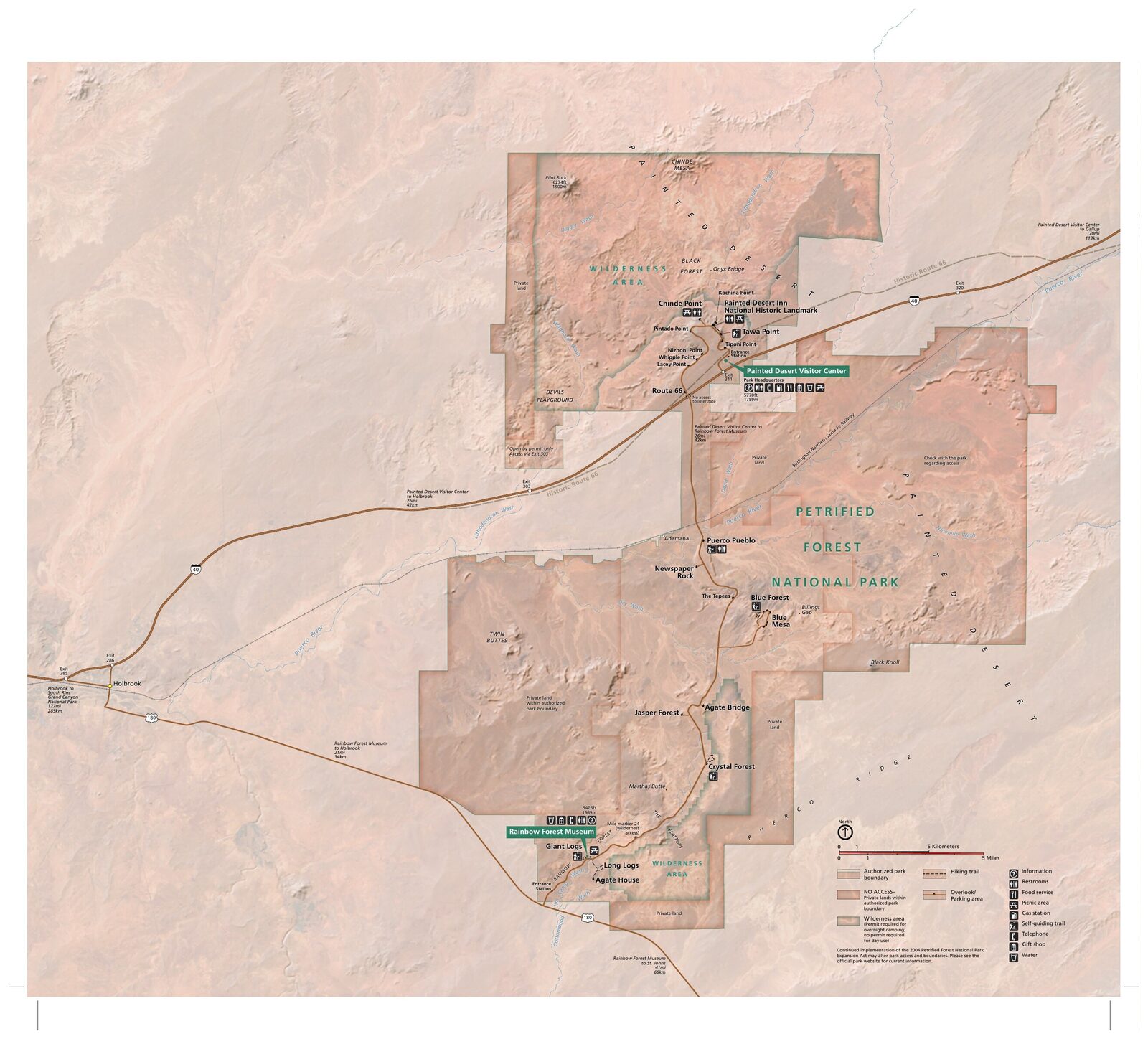
The official park map handed out at entrance stations, with roads, areas, visitor centers and services. View it here or download it for offline use.
Download the map (PDF) Public domain · National Park ServiceWhere Is Petrified Forest?
The park is in Apache County, Arizona, about 211 miles east of Flagstaff and 267 miles east of Phoenix. The Painted Desert borders it to the north. This broad plateau, streaked with purple, red, and lavender clay layers, has been part of the park since 1932.
On a map of the United States, Petrified Forest occupies a strategic location. The historic Route 66 runs through the park, and a few sections are still visible. The broader Southwest region places the park in northeastern Arizona, between Canyon de Chelly to the west and Monument Valley to the northeast.
Downloading the Official Petrified Forest Map (NPS Unigrid)
The NPS publishes a Petrified Forest "Unigrid" map. It's a large-format, double-sided brochure available for free at both entrance stations and as a PDF at nps.gov/pefo/planyourvisit/maps.htm.
Here's what the official map includes:
- The route of Park Road (30 miles), the only road crossing the park from north to south
- The 13 marked parking areas and overlooks
- The two visitor centers (Painted Desert Inn and Rainbow Forest Museum)
- Wilderness areas (backcountry)
- A simplified geological diagram of the Chinle Formation
One practical tip is to print the PDF before you leave. Cell service is very limited inside the park, and no app can replace a paper map when you're 12 miles from the entrance station.
The Sections of Petrified Forest
The park is divided into two distinct geographic sections, separated by I-40 as it crosses the park midway through.
North Section: the Painted Desert
The north section starts at the north entrance (I-40, Exit 311) and follows the edge of the Painted Desert for about 9 miles. This is where you'll find the panoramic overlooks of the colorful badlands: Tawa Point, Tiponi Point, Kachina Point, Chinde Point, Pintado Point, Nizhoni Point, Whipple Point, and Lacey Point.
The Painted Desert Inn, a historic listed building constructed in the 1920s and restored by the WPA, now serves as a museum and interpretive center. It also offers the only sheltered viewpoint over the Painted Desert.
Puerco Pueblo, accessible from this section, is a 13th-century ancestral Pueblo village with more than 100 excavated rooms and petroglyphs visible from a marked trail.
South Section: the Petrified Forest
The south section is home to the petrified wood that gave the park its name. From Rainbow Forest Museum (the south entrance, on Highway 180), several short trails bring you close to the fossilized logs.
The most striking formations have evocative names: Crystal Forest, with logs covered in purple quartz crystals; Jasper Forest, with a bird's-eye view of logs scattered across the ravine; and Giant Logs, a 1,300-foot trail starting at Rainbow Forest Museum, where some logs are more than 10 feet in diameter.
Blue Mesa, a short distance from Park Road, offers a panorama of blue-gray bentonite badlands that are especially photogenic in the late afternoon.
Park Entrances and Driving Through the Park
Petrified Forest has two entrances, and each one makes sense depending on your direction of travel.
North entrance (I-40, Exit 311) is for travelers coming from the east or planning to drive through the park from north to south. Enter at Painted Desert Visitor Center, follow Park Road south for 30 miles, and exit onto Highway 180 near Rainbow Forest Museum.
South entrance (Highway 180) is for travelers coming from Holbrook or Show Low. Enter at Rainbow Forest Museum and drive north to I-40.
Driving straight through the park without stopping takes about 45 minutes. With stops at the overlooks, allow 3 to 5 hours. The speed limit on Park Road is 45 mph, with reduced limits of 25 mph near parking areas.
Keep in mind that there's no cross-park road connecting the two sections. If you enter from the north and want to return to your starting point, you'll need to go around via I-40 and Highway 180, about 47 miles outside the park.
The park is closed on Thanksgiving and Christmas Day. Park Road hours may change during severe weather, including snow or the thunderstorms that are common in summer.
Points of Interest and Overlooks on the Map
The 13 marked stops along Park Road offer very different perspectives. Here are a few to locate on your map before you leave:
Painted Desert Rim (north section): the series of overlooks between Tawa Point and Lacey Point offers successive views of the badlands. Each one has its own angle of light. Morning brings out the orange tones, while sunset brings out the purples.
Puerco Pueblo (north section, about 12 miles in): you can see the petroglyphs from the parking area without taking an additional hike.
Newspaper Rock (central section): a rock outcrop covered in petroglyphs, visible from an overlook with a provided telescope.
Blue Mesa (central section): a 3.1-mile loop descends into a landscape of blue bentonite hills. The route details and elevation gain are in the Petrified Forest hiking guide.
Agate Bridge (south section): a 100-foot-long petrified log that spans a ravine like a natural bridge.
Crystal Forest and Giant Logs (south section): the two essential trails for getting within a few feet of the petrified wood. Loop times and difficulty levels are in the Petrified Forest activities guide.
Nearest Towns and Airports
The nearest town is Holbrook, 15.5 miles west of the north entrance via I-40. Flagstaff (211 miles) and Phoenix Sky Harbor, PHX (267 miles, about 4.5 hours), are the main regional gateways. For airport and route details, see how to reach Petrified Forest from Phoenix or Albuquerque.
Hiking Maps and Paper Topographic Guides
The NPS Unigrid map is sufficient for driving through the park and following marked trails. Hikers who want to venture into the backcountry need more detailed topographic maps, as a wilderness permit is required.
USGS 1:24,000 maps covering the park are available on the USGS website or at specialty travel bookstores. National Geographic Trails Illustrated publishes a waterproof, laminated map of the park. You can find it at outdoor stores or order it before you leave.
Rainbow Forest Museum sells a few books and maps at its counter. Stock is limited, so it's best to plan ahead.
Frequently Asked Questions
Where is the petrified forest located?
Petrified Forest National Park is in northeastern Arizona, about 211 miles east of Flagstaff. You can reach it via Interstate 40 (Exit 311 for the north entrance) or Highway 180 (south entrance).
How much does it cost to enter Petrified Forest?
The fee is $25 per private vehicle, $20 for a motorcycle, and $15 per person entering on foot or by bicycle. The America the Beautiful annual pass ($80) covers this entrance fee and admission to all national parks. For entrance fees and annual passes, see the National Parks Fees & Passes page.
What is the closest town to the petrified forest?
Holbrook, Arizona, is the closest town, about 15.5 miles west of the north entrance via I-40. It has the vast majority of the nearby lodging.
Is there an official Petrified Forest map I can download?
Yes. The NPS publishes a free Unigrid PDF map at nps.gov/pefo. It's also distributed at the park entrance when you pay the entrance fee.
Can you drive through Petrified Forest?
Yes. Park Road crosses the park for 30 miles, from Painted Desert Visitor Center (north, I-40) to Rainbow Forest Museum (south, Highway 180). The drive takes about 45 minutes without stops. With stops at the overlooks, allow 3 to 5 hours.
How long does it take to visit Petrified Forest?
A half day is enough to drive through the park and make the main stops. A full day lets you add two or three hikes. The Petrified Forest itinerary guide offers plans based on how much time you have.