

Olympic National Park Map: Regions, Roads, and the Official Map
Olympic National Park covers the Olympic Peninsula in northwestern Washington. The park spans about 1,429 square miles and has a rare feature: three distinct ecosystems side by side, temperate rain forest, glaciated mountains, and Pacific coastline. The official NPS Unigrid map is available as a free download from the National Park Service website, with a direct link below.
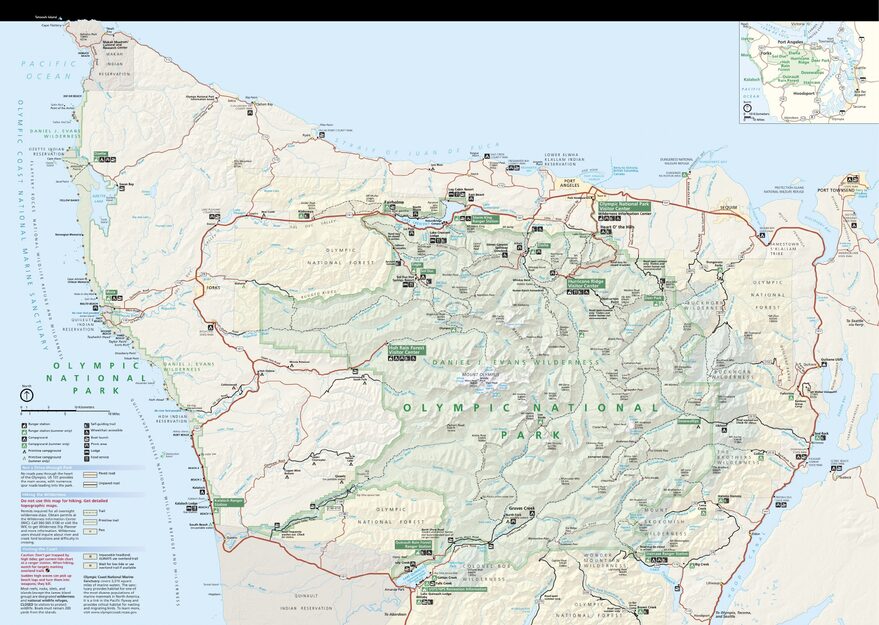
The official park map handed out at entrance stations, with roads, areas, visitor centers and services. View it here or download it for offline use.
Download the map (PDF) Public domain · National Park ServiceWhere Is Olympic National Park?
Olympic National Park occupies most of the Olympic Peninsula, the stretch of land that reaches southwest between Puget Sound and the Pacific Ocean. The park is in Washington, in the far northwest corner of the United States, less than 124 miles from Seattle.
Highway 101 circles the peninsula. It's the main road around the park, but it doesn't cross straight through it. That's the first thing to understand when looking at the map: there's no drivable east-west route through the center. You reach each region from Highway 101 by taking a secondary road that ends there.
To place the park in its broader national context, our complete guide to Olympic National Park offers regional background and an overview of the Pacific Northwest.
Download the Official Olympic National Park Map (NPS Unigrid)
The National Park Service publishes a Unigrid map for every park. It's the official map handed out at the entrance. For Olympic, this PDF shows:
- the entire peninsula and access roads from Highway 101;
- the park's three main regions, mountains, rain forest, and coast;
- the main campgrounds, visitor centers, and trailheads.
The file is available for free on the NPS Maps page (nps.gov/olym/planyourvisit/maps.htm). Download it before you leave because cell service is unavailable across much of the park.
Olympic National Park Regions
Olympic is unlike any other park because it is literally discontinuous. The coastal region, known as the Olympic Coast, is separated from the interior by a strip of private land. The map therefore shows two distinct areas.
The Mountain Core (Hurricane Ridge and the Olympic Mountains)
This is the park's most photographed region. Hurricane Ridge reaches about 5,250 feet and offers open views of snow-covered peaks, including Mount Olympus at 7,979 feet. You reach it from Port Angeles in the north via a paved road that runs for 17 miles. This region has most of the park's alpine hikes.
The Temperate Rain Forests (Hoh, Quinault, and Queets)
To the west, the river valleys receive up to 138 inches of precipitation a year, creating spectacular moss-covered forests. The Hoh Rain Forest and Lake Quinault visitor centers are the two main gateways to this region.
The Pacific Coast (Olympic Coast)
A wild coastline stretching for more than 62 miles, reached by a few roads and trails from the small communities of Forks and La Push. The beaches are windswept and unguarded. Surf and swimming conditions vary sharply with the tide.
The Eastern Region (Hood Canal and Staircase)
Less crowded, this region follows Hood Canal and lets you avoid the summer crowds in the mountain regions.
Park Entrances and Internal Roads
Olympic National Park is open 24 hours a day year-round. Some roads and campgrounds close in the off-season, usually from October through May at higher elevations.
Current entrance fees:
- Private vehicle: $30
- Motorcycle: $25
- Pedestrian or cyclist: $15
- Olympic annual pass: $55
- America the Beautiful Pass, valid at all federal recreation sites: $80
For entrance fees and annual passes, see the National Parks Fees & Passes page.
There's no internal driving loop through the park. Each secondary road branches off Highway 101 and returns to the same point. Plan your visit region by region, rather than as one continuous circuit. For distances from Seattle, ferry options, and car rentals on the peninsula, the guide to getting to Olympic has all the practical details.
Points of Interest and Viewpoints to Find on the Map
These are the priority points of interest to locate on your map:
- Hurricane Ridge Visitor Center: panoramic views of the Olympic Mountains, accessible by car.
- Hoh Rain Forest Visitor Center: the heart of the temperate rain forest and the trailhead for the Hall of Mosses.
- Ruby Beach: a coastal beach with sea stacks and the most accessible beach on the Olympic Coast.
- Sol Duc Hot Springs: developed hot springs in the forest, in the northwest region.
- Lake Crescent: a deep-blue glacial lake along the road between Port Angeles and Forks.
For details on activities at each of these sites, the guides Things to Do in Olympic and Hiking in Olympic cover each option.
Nearest Towns and Airports
Port Angeles (about 20,000 residents) is the main gateway town, 19 miles north of the Hurricane Ridge Visitor Center. It has a ferry terminal with service to Victoria, British Columbia.
Seattle is the nearest major metropolitan area, about 106 miles east. Seattle-Tacoma International Airport (SEA) is the closest major air hub. Allow 2.5 to 3 hours to reach Port Angeles, depending on the wait for the Kingston or Bainbridge Island ferry.
Forks, on the west side of the peninsula, is a base for the rain forest and coast. It's a small town, but it has motels and gas stations. Lodging by region, from lodge-style hotels to backcountry camping, is covered in the Olympic lodging guide.
Hiking Maps and Printed Guidebooks
The NPS Unigrid map works for general orientation, but it doesn't replace a topographic map for high-elevation or off-trail hikes. For the Olympic Mountains, hikers use USGS 1:24,000 maps. Specialty bookstores, including Cartovia and Librairie du Voyage, also carry ITM Washington maps and local Green Trails maps. These cover each region with contour lines and numbered trailheads.
Frequently Asked Questions
Where is Olympic National Park on a map of the United States?
Olympic National Park is in Washington, in the far northwest corner of the United States, on the Olympic Peninsula, about 106 miles northwest of Seattle.
Does Olympic National Park have an official map, and can you download it?
Yes. The National Park Service offers a free PDF map in Unigrid format on its official website (nps.gov/olym). You can also get a paper copy at the park entrance.
Can you drive all the way across Olympic National Park?
No. No road crosses the park from east to west. Highway 101 circles the peninsula, while all internal roads end after branching off this main loop.
What's the best viewpoint in Olympic National Park?
Hurricane Ridge is the most accessible viewpoint by car for snow-covered peaks. For a forest experience, Hoh Rain Forest is the clear choice. Our Things to Do page covers options by region and walking difficulty.
What's the closest town to Olympic National Park?
Port Angeles is the closest town to the northern mountain region, including Hurricane Ridge. For the coast and rain forest, Forks is the main logistical base on the west side.
How much time do you need to visit Olympic National Park?
The park is too spread out to see in one day. Our 2- to 5-day Olympic itineraries cover the priority regions based on the length of your stay.