
Glacier Hiking Guide: Best Trails for Every Skill Level
Glacier National Park has more than 680 miles of marked trails, where alpine meadows, old-growth cedar forests, and active glaciers unfold within just a few miles of one another. This isn't a park for checking off a quick hike. Its signature trails deserve a real half-day or a full day.
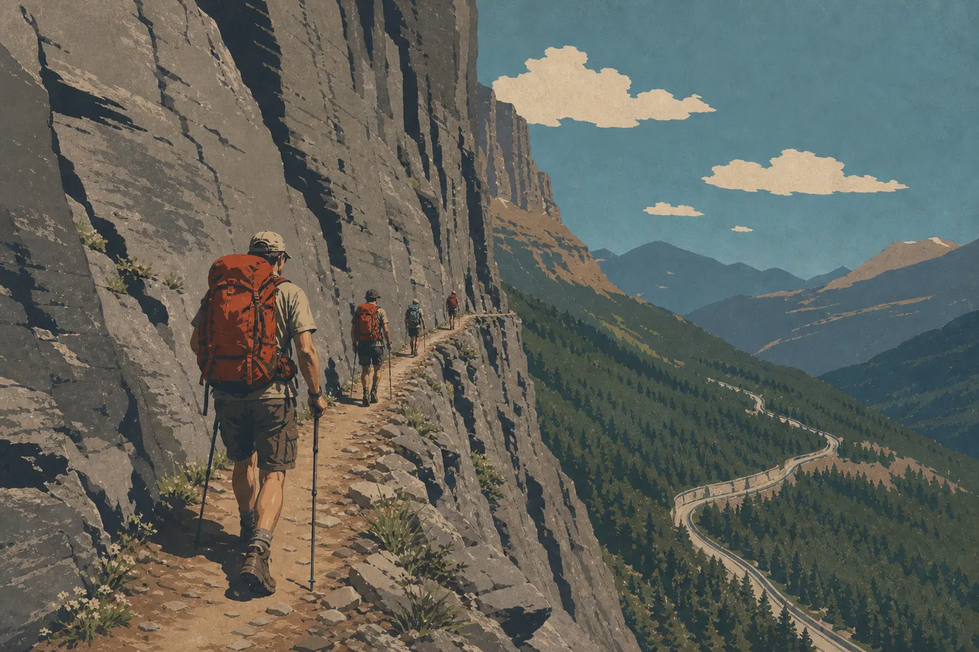
If you only do one hike, make it the Highline Trail, starting at Logan Pass. It's a 7.5-mile one-way route along the cliffs, with a shuttle ride back. If you've got one day and strong legs, this is the one. For families, Hidden Lake Overlook (3 miles round-trip, with moderate elevation gain) delivers big views and mountain goats without requiring peak fitness. To see a real glacier, the Grinnell Glacier Trail in the Many Glacier area is the park's standard-bearer.
Getting Ready for a Glacier Hike
Vehicle Entry Permits and Timed Entry
The Going-to-the-Sun Road, the park's main artery, requires a timed entry reservation during the busy season, generally from mid-May to early September. Without a ticket obtained through recreation.gov, you can enter only before 6 a.m. or after 5 p.m. Tickets sell out several weeks in advance. Day hikes don't require an additional permit. The entrance fee, $35 per vehicle and valid for 7 days, is enough.
Grizzly and Black Bears: Nonnegotiable Rules
Glacier is home to both black bears and grizzlies, with a notable number of grizzlies in the Many Glacier area. The rules are simple and mandatory. Hike in groups of at least three on trails frequented by grizzlies, carry bear spray where you can reach it rather than at the bottom of your pack, and make noise regularly as you walk. Calling out “Hey, bear!” every two minutes works better than bear bells, according to park rangers.
Dogs on Trails
Dogs are prohibited on nearly all Glacier trails, including the Highline Trail, Grinnell Glacier, and Iceberg Lake. They're allowed on a leash no longer than 6 feet on paved roads and in campgrounds. Check nps.gov/glac trail by trail before making plans with your dog.
Treat All Water
Glacier's lakes and rivers look crystal clear, but giardia is present. Use a pump filter, iodine tablets, or a Sawyer-style filter. Choose your method, but never drink untreated water straight from a source. Carry at least 2 liters when you set out.
High-Elevation Safety
Elevation gain and exposure vary considerably from one trail to another. On the Highline, some sections run beside sheer cliffs with a hand cable. If you're prone to vertigo, this isn't the trail for you. Weather changes fast in Glacier. Check the Glacier weather forecast for details. Thunderstorms can roll in early in the afternoon starting in July, and snow is possible at higher elevations into August. An early start, sturdy hiking shoes, and a waterproof layer should always be part of your routine.
The Best Hikes, Area by Area
Logan Pass: The Park's Alpine Heart
At 6,646 feet, Logan Pass is the highest point on the Going-to-the-Sun Road and the starting point for two of the park's most iconic hikes. The parking lot is often full before 9 a.m. in summer. Arrive early or take the free shuttle from Apgar or St. Mary.
Highline Trail 7.5 miles one way · moderate elevation gain · 4 to 5 hours · moderate · one way with shuttle Trailhead: Logan Pass parking lot
The Highline starts along a cliffside at Logan Pass, following a route blasted into the rock with dynamite in the early 20th century. The first few hundred feet run beside a sheer wall with a hand cable. It's a natural filter for hikers prone to vertigo. Once you're past that section, the trail widens and opens onto alpine meadows where mountain goats graze just a few feet from hikers. Marmots are a sure thing. A grizzly is possible, so keep your distance.
We recommend hiking one way to Granite Park Chalet, then taking the shuttle down from The Loop. The park's free shuttles make the connection during the season. You can hike round-trip, but that stretches the outing to 15 miles and takes a serious toll on your legs.
Seasonal tip: The trail is generally available from mid-July through late September, depending on snow conditions. In July, snow patches remain on some sections. Trekking poles are recommended.
Hidden Lake Overlook 3 miles round-trip · 900 feet of elevation gain · 1.5 to 2 hours · easy to moderate · round-trip, with an optional extension Trailhead: Logan Pass Visitor Center
The trail starts on wooden boardwalks through alpine meadows, then climbs gently to an overlook of Hidden Lake and the surrounding peaks. This is Glacier's most accessible trail. It's popular and sometimes crowded in peak season, but the views and close encounters with mountain goats make sharing the trail worthwhile.
You can continue down to the lake itself, making 4.3 miles round-trip, which adds elevation gain and plenty of peace and quiet. Most of the crowds stop at the overlook.
Many Glacier: Wildlife and Active Glaciers
This is our favorite area in the park. Built in 1914 on the shore of Swiftcurrent Lake, Many Glacier Hotel serves as the starting point for several of Glacier's most impressive hikes. The grizzly population is among the highest in the continental United States. Early outings are strongly recommended, as are groups of three or more.
Grinnell Glacier Trail 11 miles round-trip, or about 6.8 miles with the boat option · 1,410 feet of elevation gain · 5 to 7 hours · moderate to difficult · round-trip Trailhead: Many Glacier Hotel or Swiftcurrent Lake boat dock
Grinnell Glacier is one of the few glaciers in the park you can still reach on foot. In 1850, Glacier had more than 150 glaciers. About 20 remain. Reaching the edge of the glacial lake and seeing the blue ice face makes the loss tangible. It's an experience that stays with you.
Boat option, for a fee: Take a boat across Swiftcurrent and Josephine Lakes to cut off the first part of the route, reducing the hike to about 6.8 miles round-trip. It's a good choice when time or energy is limited.
Trailhead: Many Glacier Hotel or Swiftcurrent Lake trailhead. The parking lot is often full before 8 a.m. in August. The shuttle from Many Glacier Campground is a practical alternative.
- Distance
- 9.4 miles
- Elevation gain
- 1,230 feet of elevation gain
- Duration
- 4 to 6 hours
- Difficulty
- moderate
- Type
- round-trip
Trailhead: Swiftcurrent Motor Inn, Many Glacier
Iceberg Lake gets its name from the chunks of ice that float on its surface into August, and sometimes September. The cirque's north-facing walls keep the sun from reaching the water long enough to melt the winter ice. The trail is less demanding than Grinnell in terms of elevation gain, and the cirque's landscape is striking. Grizzlies regularly use this corridor.
- Distance
- 2.6 miles
- Elevation gain
- nearly flat
- Duration
- 1 hour
- Difficulty
- easy
- Type
- loop
Trailhead: Many Glacier Hotel
This flat loop around Swiftcurrent Lake is ideal for evening wildlife watching. Look for ducks, beavers, and elk along the shore, and sometimes a grizzly on the slopes across the lake. We recommend it for visitors who arrive in the area in the afternoon and want to enjoy the late-day light without committing to a long trail.
Lake McDonald and Apgar: Accessible Forests and Waterfalls
The park's wetter west side is dominated by old-growth cedar and hemlock forests. The hikes here are less dramatic from an alpine perspective, but they're accessible early in the season and wonderfully relaxing.
- Distance
- 0.9 miles
- Elevation gain
- flat
- Duration
- 30 minutes
- Difficulty
- very easy
- Type
- loop
Trailhead: Avalanche Creek parking lot
This loop follows wooden boardwalks through a forest of centuries-old cedars and hemlocks. The Avalanche Creek gorge and moss-covered trunks create an atmosphere all their own. It's partially accessible to visitors with mobility limitations and works well for very young children.
You can combine it with the Avalanche Lake Trail (4.7 miles round-trip, 705 feet of elevation gain, easy to moderate). The trail follows Avalanche Creek and ends at a lake surrounded by waterfalls dropping from the cliffs.
Two Medicine and St. Mary: Quiet Trails and Waterfalls
These two areas see fewer visitors than Logan Pass and Many Glacier. They're worth a stop if you're spending two days in the park or want to get away from the crowds.
- Distance
- 3.4 miles round-trip to Virginia Falls
- Elevation gain
- 460 feet of elevation gain
- Duration
- 2 hours
- Difficulty
- easy to moderate
- Type
- round-trip
Trailhead: St. Mary Falls trailhead, with the shuttle recommended during the season
The trail follows the St. Mary River before dropping toward two successive waterfalls. St. Mary Falls, 1.2 miles from the start, is the more popular destination. Virginia Falls, at 1.7 miles, is taller and noticeably less crowded. It's a good option for families who want a clear destination without too much elevation gain.
- Distance
- 0.6 miles
- Elevation gain
- flat
- Duration
- 20 minutes
- Difficulty
- very easy
- Type
- round-trip
Trailhead: Running Eagle Falls parking lot, Two Medicine Road
This geological curiosity changes with the season and water level. The waterfall either drops over the upper edge of the cliff or emerges from an opening halfway down the rock. Both sources are visible at the same time in spring, which explains the nickname “Trick Falls.” It's short, accessible, and easy to explain to kids.
Easy Hikes for Families
For children and hikers easing back into the outdoors, here's a selection with no unpleasant surprises:
| Trail | Distance | Area | Highlight |
|---|---|---|---|
| Running Eagle Falls | 0.6 mi RT | Two Medicine | Double waterfall, completely flat |
| Trail of the Cedars | 0.9 mi loop | Lake McDonald | Cedar forest, partially accessible |
| Swiftcurrent Lake Nature Trail | 2.6 mi loop | Many Glacier | Wildlife, sunset |
| St. Mary Falls | 2.7 mi RT | St. Mary | Waterfall, riverside |
| Hidden Lake Overlook | 3 mi RT | Logan Pass | Panoramic views, mountain goats |
Tip: Cool July and August mornings are the best time to hike with kids. The guide to visiting Glacier with your family covers campgrounds and other family-friendly activities.
Challenging Hikes: Elevation Gain and Views
Experienced hikers will find trails in Glacier that deliver. Fitness alone isn't enough. Managing exposed sections at elevation and reading the sky are part of the equation.
Siyeh Pass Trail: About 12 miles round-trip, with roughly 3,000 feet of elevation gain. This is a wild, lightly traveled traverse compared with the Highline, and one of the park's most demanding and scenic trails.
Ptarmigan Tunnel: 10.6 miles round-trip from Many Glacier, with 1,700 feet of elevation gain. The trail passes through a tunnel cut into the rock at 7,677 feet, opening onto views toward the Belly River. It's open only in summer and closed in the off-season.
Sperry Glacier: 16.2 miles round-trip from Lake McDonald Lodge, with 3,150 feet of elevation gain. This is the park's longest hike, with the option to spend the night at Sperry Chalet. Reservations are required and highly sought after. A wilderness permit is required for any overnight stay outside official facilities.
For all of these challenging outings, visit the Glacier park home page for links to guides covering wildlife, wilderness permits, and high-elevation weather.
Access, Trailheads, and Parking
Most major trailheads are reached via the Going-to-the-Sun Road, which is open from mid-June to mid-October depending on snow conditions. In peak season, July and August, the parking lots at Logan Pass and Many Glacier Hotel are full before 9 a.m.
Three practical approaches:
The park's free shuttle runs along the Going-to-the-Sun Road from mid-July to early September. Board at Apgar or St. Mary and get off at your trailhead. There's no parking stress and no additional cost.
Arrive before 8 a.m. and you'll usually find a spot. There's another benefit: morning light is better for photos, and wildlife is more active.
Many Glacier isn't on the Going-to-the-Sun Road and isn't subject to timed vehicle entry. The park entrance fee, $35 per vehicle, is still required.
For options from Kalispell and Great Falls, as well as public transportation connections, getting to Glacier and getting around the park each have their own dedicated guide.
When Should You Hike in Glacier?
Mid-July through mid-September is the optimal window. Before mid-July, snow blocks high-elevation trails such as the Highline, Grinnell Glacier, and Ptarmigan Tunnel, and the Going-to-the-Sun Road isn't fully open. After mid-September, temperatures drop quickly and some roads close.
See when to visit Glacier for month-by-month details on road access, weather, and crowds.
Which Hike Is Right for You?
| Hiker profile | Recommendation |
|---|---|
| First time in Glacier, good fitness | Hidden Lake Overlook and Highline Trail, with a shuttle back |
| Family with kids ages 5 to 10 | Trail of the Cedars and Running Eagle Falls |
| Wildlife watching | Swiftcurrent Lake Nature Trail in Many Glacier, early morning |
| See a real glacier | Grinnell Glacier Trail in Many Glacier |
| Experienced hiker, full day | Siyeh Pass or Ptarmigan Tunnel |
| Short on time, half-day | St. Mary Falls or Hidden Lake Overlook |
| Alpine landscape photography | Highline Trail at sunrise |
To build a complete itinerary, the Glacier itinerary guide offers 2- to 5-day trips combining hikes with other park activities.
Frequently Asked Questions
What's the best hike in Glacier National Park?
The best hike in Glacier depends on your ability, but rangers and regular visitors consistently point to the Highline Trail, a moderate 7.5-mile one-way hike, as the trail that best represents the park. It combines alpine exposure, varied wildlife, and 360-degree views of the Montana plains.
Is hiking in Glacier difficult?
Hiking in Glacier isn't inherently difficult, but high-elevation trails combine elevation gain with exposed sections. Very accessible trails such as the flat 0.9-mile Trail of the Cedars coexist with hikes involving 3,000 feet of elevation gain for experienced hikers.
Is it safe to hike in Glacier National Park?
Hiking in Glacier is safe when you follow wildlife precautions. Keep bear spray in hand, hike in groups of at least three in grizzly country, especially Many Glacier, and make regular noise as you walk. Weather changes quickly at elevation, so an early start and a waterproof layer are still the rule.
Do I need a permit to day hike in Glacier?
Day hiking in Glacier doesn't require a specific permit. The entrance fee, $35 per vehicle or $20 per person, is enough. A wilderness permit is required only for overnight stays outside official campgrounds and chalets.
Are there easy family-friendly hikes in Glacier?
Glacier has several easy hikes for families. The Trail of the Cedars (0.9 miles, flat), Running Eagle Falls (0.6 miles, flat), and Swiftcurrent Lake Nature Trail (2.6 miles, nearly flat) all work well with kids. Our Family Guide adds to these suggestions.
Can I hike with my dog in Glacier?
Dogs aren't allowed on nearly all trails in Glacier National Park. They're permitted on a leash in campgrounds and on paved roads. Check nps.gov/glac for trail-by-trail exceptions.
What's the best time of year to hike in Glacier?
The best time to hike in Glacier is from mid-July through mid-September, when the high-elevation trails are clear and the Going-to-the-Sun Road is fully open. Our When to Visit page explains conditions month by month.
Are there loop hikes in Glacier?
Glacier has several loop trails, including Trail of the Cedars (0.9 miles), Swiftcurrent Lake Nature Trail (2.6 miles), and the loop around Two Medicine Lake, about 5 miles. Hikers most often do the Highline Trail one way and take the shuttle back.
How do I reach the trailheads and park at Glacier?
The main trailheads are reached via the Going-to-the-Sun Road, which requires timed vehicle entry during the peak season. The park's free shuttles serve the trailheads from mid-July to early September. Our Access and Transportation Guide and Getting Around Guide cover all the options.