
Denali Map: Layout, Areas, and Official Map Download
Denali National Park & Preserve is in Alaska on Highway 3 (George Parks Highway), about 5 hours north of Anchorage and 2 hours south of Fairbanks. The park covers roughly 9,300 square miles of tundra, boreal forest, and glaciers, crossed by a single main road stretching 92 miles. The official NPS map (Unigrid) is available free online, and we'll show you how it's organized and how to use it to plan your visit.
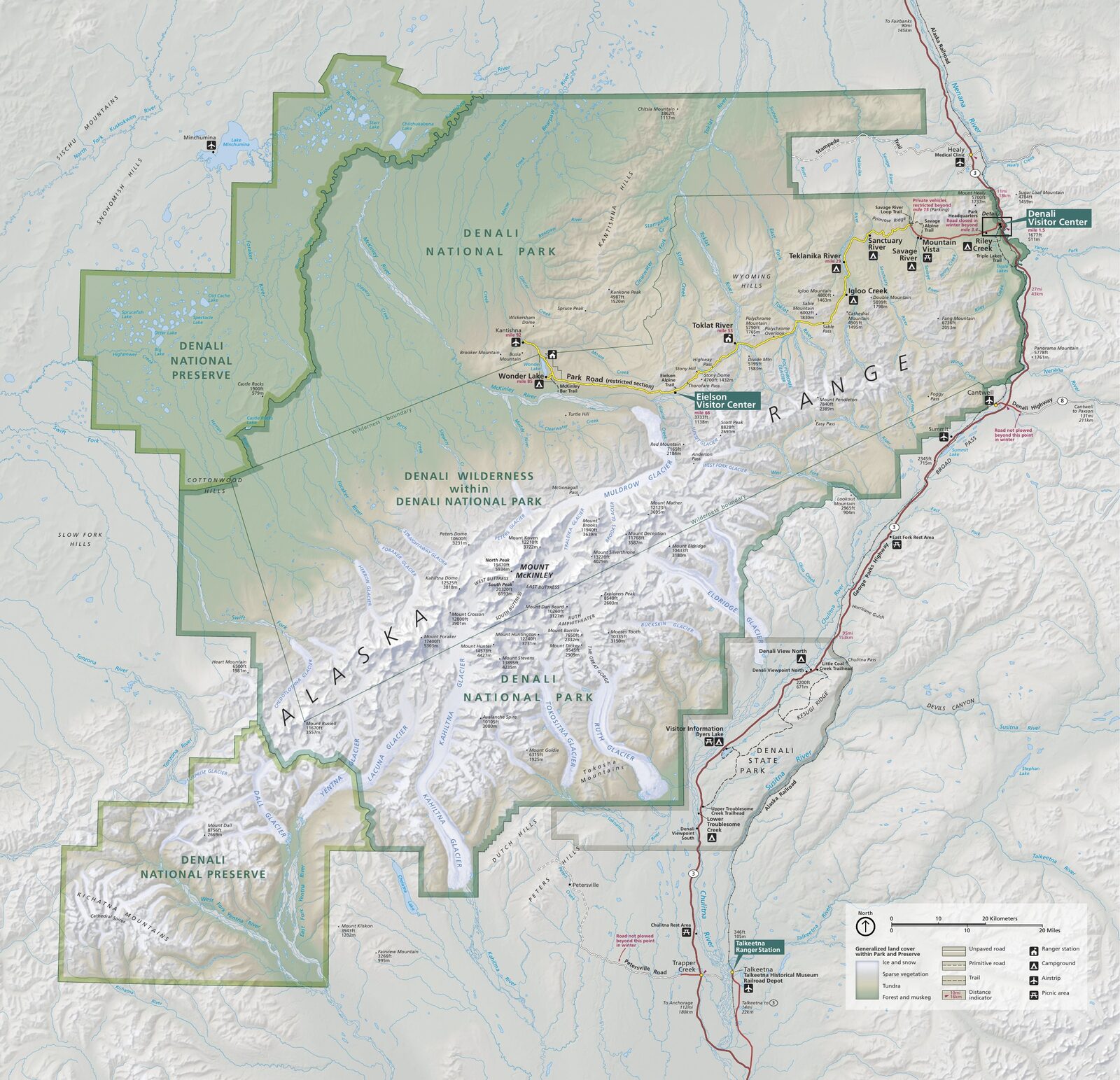
The official park map handed out at entrance stations, with roads, areas, visitor centers and services. View it here or download it for offline use.
Download the map (PDF) Public domain · National Park ServiceWhere Is Denali?
Denali is in Alaska's Alaska Range, halfway between the state's two largest cities. On a map of the United States, it's way up in the northwest: picture a vertical line between Anchorage and Fairbanks, with the park sitting along it, slightly north of center. Denali (20,310 feet), the highest point in North America, dominates the horizon west of the road. On a clear day, you can spot it from the park entrance, but the clouds often have other plans.
To place Denali among Alaska's national parks, the regional Alaska guide provides the key geographic reference points.
Download Denali's Official NPS Unigrid Map
The National Park Service publishes Denali's Unigrid map as a free PDF on its website. It shows the Denali Park Road, campgrounds, visitor areas, park boundaries, and the general terrain. It's the reference document to use when you're getting familiar with the geography before you arrive. Rangers also hand out paper copies at the park entrance, at the Riley Creek Entrance.
For a direct download, go to the NPS Maps page (nps.gov/dena/planyourvisit/maps.htm).
Denali's Areas
The park is organized along a single route, the Denali Park Road, which runs 92 miles from the eastern entrance to the hamlet of Kantishna in the west. There are three main areas, from the most accessible to the most remote.
Entrance Area: Riley Creek (Mile 0 to 15)
This is the only paved section, open to all private vehicles as far as the Savage River checkpoint, about mile 15. You'll find the main Visitor Center, Riley Creek Campground, and the first unobstructed views of the tundra here. Every visit starts in this area.
Central Corridor: Savage River to Eielson (Mile 15 to 66)
Beyond Savage River, the road turns to gravel, and private vehicles aren't allowed except on a few special days in September during the Road Lottery. The only way to travel this section is on the park's green buses, which require reservations. The route passes Polychrome Overlook, follows the banks of the Toklat River, and reaches Eielson Visitor Center at mile 66, an overlook for the mountain range when the skies are clear.
Deep Interior: Wonder Lake and Kantishna (Mile 66 to 92)
The final third of the road is the most remote. In favorable conditions, Wonder Lake, around mile 85, reflects Denali on its surface. It's the view featured in many of the park's iconic photos. Kantishna, the road's terminus, is a private hamlet with no public services for ordinary visitors.
Park Entrances and Driving Across Denali
There is one official entrance, off Highway 3. There is no physical gate or toll booth that closes at night, so the park is open 24 hours a day. The entrance fee, $15 per person or $45 for the annual pass, can be paid online or at the Visitor Center.
Standard visitors can't drive across Denali from east to west. The 77 miles of unpaved road are closed to private vehicles from spring through fall. Park buses provide the entire shuttle service to Wonder Lake and Kantishna. To reserve a park bus and compare rental-car options from Anchorage or Fairbanks, the Denali access guide walks you through every step.
Points of Interest and Map Viewpoints
Here are the landmarks to locate first on your Unigrid map:
- Savage River Overlook (mile 15): first panorama of the tundra, accessible by private vehicle.
- Polychrome Overlook (around mile 43): multicolored cliffs with expansive views of the Alaska Range.
- Eielson Visitor Center (mile 66): permanent exhibit about Denali and a viewpoint of the summit when the sky is clear.
- Wonder Lake (mile 85): a calm lake with views reflected from the mountain range. Take a late-day bus to avoid the afternoon winds.
- Denali summit (20,310 feet): visible from several points along the road; climbing it requires a separate NPS mountaineering permit.
For the complete list of activities, see Things to Do in Denali. Marked trails are listed in the Denali hiking guide.
Nearest Towns and Airports
The nearest airports are Anchorage (ANC, 230 miles south) and Fairbanks (FAI, 124 miles north). Healy is the gateway town, 11 miles from the park entrance. For transportation options and travel times, see the Denali Access & Transportation guide.
Paper Hiking Maps and Topographic Guides
The NPS Unigrid map covers the road and visitor areas well, but it doesn't provide enough detail for off-trail hiking in the backcountry. Here are two alternatives:
- National Geographic Trails Illustrated No. 222 (Denali National Park): a water-resistant laminated map at a scale of 1:125,000, with backcountry campsites and water sources marked. This is the map we take into the field, and you can find it at specialty travel bookstores and online.
- USGS 1:63,360 maps (7.5-minute quadrangles): the standard used by U.S. federal agencies, available through the USGS Store. They're essential for off-trail areas where every contour line matters.
Frequently Asked Questions
Where is Denali?
Denali National Park & Preserve is in Alaska, on Highway 3 (George Parks Highway), about 230 miles (5 hours by road) north of Anchorage and 124 miles (2 hours by road) south of Fairbanks.
Where is Denali on the map?
Denali, at 20,310 feet, is in the western part of the park, about 81 miles from the entrance along the main road. You can see it from several points along the Denali Park Road, especially at Eielson Visitor Center (mile 66), when the weather is clear.
What are the must-see places in Denali?
The landmarks you shouldn't miss are Polychrome Overlook (mile 43, with views of the Alaska Range), Eielson Visitor Center (mile 66, with a panorama of the summit), and Wonder Lake (mile 85, with reflections of Denali). The complete list is in the Things to Do in Denali guide.