
Chiricahua Map: Official NPS Park Map and Key Landmarks
Chiricahua National Park sits in southeastern Arizona, in the Chiricahua Mountains. Only one paved road enters, from the west, and it climbs Bonita Canyon to Massai Point, where it ends. You can download the official NPS map for free, and paper copies are available at the visitor center.
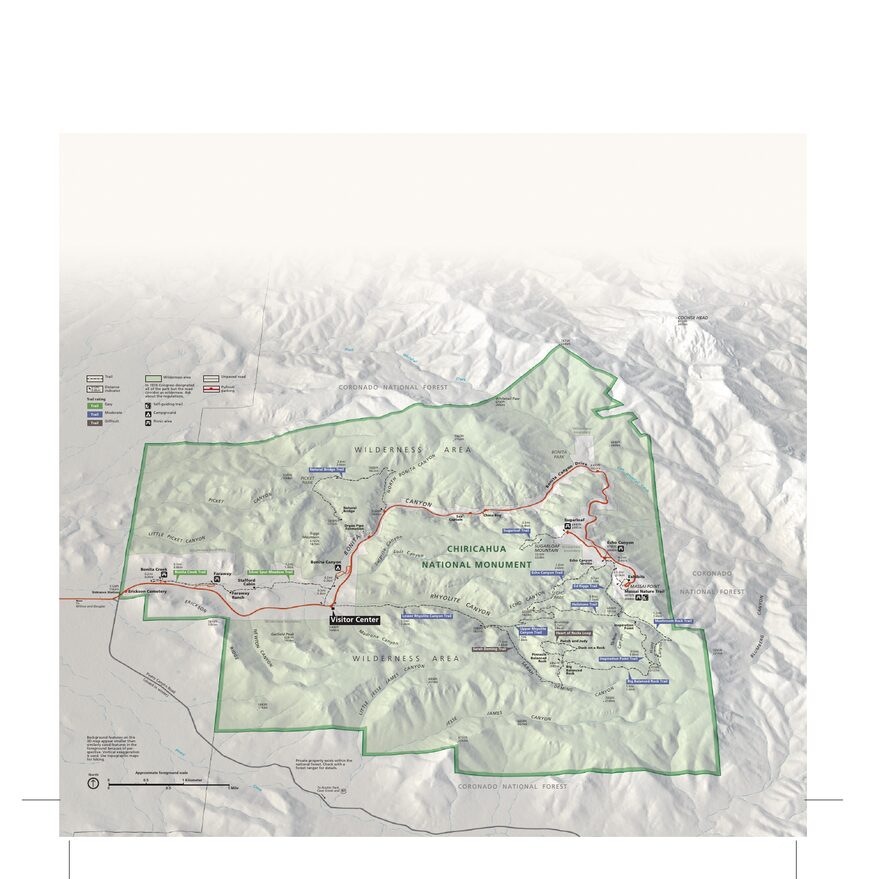
The official park map shows roads, trails and facilities. Open the preview or download the PDF for offline use.
Download the map (PDF) Public domain · National Park ServiceWhere Is Chiricahua?
The park covers part of an isolated mountain range that rises out of the desert plains. The big landmark is Interstate 10 to the north. Exit at Willcox, then take AZ-186 and AZ-181 to the entrance, about 45 minutes. The full route is covered in the getting there guide.
The range extends well beyond the park boundary, and that's the classic map trap. Portal, Cave Creek Canyon, and Pinery Canyon are part of the Chiricahuas, not the national park. Portal, on the other side of the range, isn't a second entrance, and Pinery Canyon Road (FR42) isn't a paved route through the park. If your GPS suggests either shortcut, ignore it and enter the visitor center address, 13063 E Bonita Canyon Rd.
The Official NPS Map
The official park map fits on one page. It shows the park boundary, Bonita Canyon Drive, the visitor center, the campground, and the trails around Massai Point and Heart of Rocks. It still says "Chiricahua National Monument," but the land and boundaries are the same. It isn't a complete park brochure.
Treat it as a starting point and add to it based on your plans. It doesn't cover the whole mountain range or Portal. For a long outing, add the description of the trail you've chosen and the advice you get at the visitor center.
Cell service is spotty and Wi-Fi is slow. Save the PDF before you arrive, along with an offline map, or pick up a paper copy at the visitor center.
Getting Oriented: The Lower Park, the Drive Up, and the Upper Park
Think of Chiricahua as a staircase. The terrain climbs from about 5,125 feet at the entrance to 7,310 feet at the summit of Sugarloaf Mountain.
The Lower Park: Bonita Canyon
The visitor center is about 1.9 miles from the entrance. Around it, you'll find Bonita Canyon Campground, Faraway Ranch, and the start of the Bonita Creek Loop. Fill up on water before you head up.
The Climb: Bonita Canyon Drive
Past the visitor center, the road climbs for about 6 miles through oaks and pines. Mark two points on your map. The first is the Natural Bridge trailhead, right by the road, and the second is the turnoff for Sugarloaf Mountain. Signs come up quickly in the switchbacks.
The Upper Park: Echo Canyon and Massai Point
The Echo Canyon parking area comes before the end of the road at Massai Point, a viewpoint you can drive to. From Echo Canyon, the Echo Canyon, Hailstone, and Ed Riggs trails lead into the rock formations and on to Heart of Rocks. The routes are described in the hike selection. There's no water source at the Echo Canyon parking area.
A Dead-End Road, No Shuttle
You can't drive through Chiricahua. Bonita Canyon Drive runs about 8 miles from the entrance to Massai Point, and you come back the same way. No road inside the park connects to Portal.
No hiker shuttle operates in the park, and there are no taxis or rideshare. A loop or an out-and-back brings you back to your vehicle. A one-way hike ending at the visitor center means arranging a private ride back ahead of time. Note on the map where you're parking and where you plan to finish. The road takes you to the top, but the trails drop into the canyons, so the end of a loop is often a climb back up. Parking capacities are covered in the guide to getting around the park.
Following Your Route on the Ground
Rely on four landmarks on the map: the visitor center, the Natural Bridge trailhead, the Sugarloaf Mountain turnoff, and the Echo Canyon parking area. If you change trailheads, recalculate the walking route, since the same trail won't be the same distance or the same effort from a different starting point.
Snow, ice, storms, or flash floods can change conditions on the road and trails. Check current conditions before you head up, and see the weather page for climate guidelines. Clear approach roads don't mean the upper part of Bonita Canyon Drive is clear.
Frequently Asked Questions
Where Can I Find the Official Chiricahua Map?
The official NPS map is a free PDF download. Paper copies are available at the visitor center.
Why Does the Map Say National Monument?
The map still carries the site's former name. The land and boundaries are those of the national park.
Is the Park Map Enough for Hiking?
It shows the road, the parking areas, and the trails, but it's only a starting point. For a long loop, add the trail description and the advice you get at the visitor center.
Is Portal Another Entrance to the Park?
No. Portal is on the other side of the range, and no paved road inside the park connects it to Bonita Canyon.