

Capitol Reef Map: Areas, Layout, and the Official Map
Capitol Reef lies in south-central Utah, about 200 miles south of Salt Lake City. The park stretches for 100 miles along the Waterpocket Fold, a landform that runs north to south and shapes the park's entire geography. The free official map (NPS Unigrid, in PDF format) is available for download on the NPS website. You'll find the link in the dedicated section below.
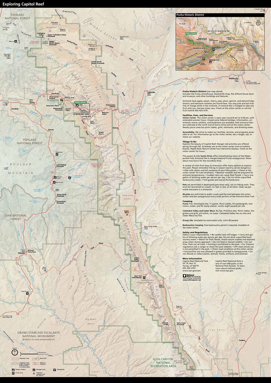
The official park map handed out at entrance stations, with roads, areas, visitor centers and services. View it here or download it for offline use.
Download the map (PDF) Public domain · National Park ServiceWhere Is Capitol Reef?
Capitol Reef occupies south-central Utah, in the Colorado Plateau region. On a map of the United States, it's at the heart of the "Grand Circle," the classic route linking the major parks of the Southwest. Bryce Canyon is about 62 miles to the west, while Canyonlands and Arches are about 93 miles to the east.
Highway 24 (UT-24) crosses the park from east to west and serves as the main reference point for visitors. South of the highway, Scenic Drive continues toward the park's densest concentration of rock formations. The park covers about 378 square miles, but most visitors stay within a corridor a few miles wide around the Fruita visitor center. The rest of the park, including Cathedral Valley to the north and Muley Twist to the south, requires a suitable vehicle and a full day.
To place Capitol Reef in its regional context and build a coherent itinerary, our Colorado Plateau Region guide provides the big picture.
Download the Official Capitol Reef Map (NPS Unigrid)
The NPS publishes a free Unigrid map of Capitol Reef as a PDF. It shows roads suitable for standard cars, roads reserved for high-clearance vehicles, major trails, and points of interest. It's the reference document to print or save offline before leaving Torrey.
It's available on the official NPS page (nps.gov/care, under "Maps"), which is updated regularly. If you're using a PDF saved from an earlier visit, check its version date.
Here's a practical tip. Cell service is nearly nonexistent across most of the park. Download the map and your GPS data for offline use in Torrey, before entering the park.
Capitol Reef's Areas
Because the Waterpocket Fold is a linear structure, the park naturally divides into three areas from north to south. Knowing them ahead of time keeps you from underestimating distances and running short on time or fuel.
Fruita and the Fremont River Valley (Central Area)
Fruita is the park's accessible heart: the visitor center, the main campground, and a historic Mormon orchard where you can pick fruit in season according to the rules posted on site. Every trail accessible without a specialized vehicle starts in this area. Scenic Drive begins just south of the visitor center. It's paved for 8 miles to the Capitol Gorge parking area, then continues as an unpaved road.
Cathedral Valley (North)
Cathedral Valley is home to red sandstone monoliths that rise nearly 330 feet in places. Access is limited to high-clearance vehicles. The roads are unpaved, and crossing the Fremont River at a ford is unavoidable. This area remains lightly visited, making it one of the park's best-preserved spaces. Allow a full day for the loop from Torrey.
Strike Valley and Muley Twist (South)
To the south, Strike Valley and Muley Twist are best suited to self-reliant hikers and four-wheel-drive owners. Routes are longer, elevation gains are steeper, and the lack of shade makes summer heat especially demanding. This is where the Waterpocket Fold is easiest to read from the ground. Our Capitol Reef hiking guide covers the trails available in this area and their access conditions.
Park Entrances and Driving Across the Park
Capitol Reef has no traditional entrance gate for vehicles traveling on UT-24. This public road passes freely through the park, with no barrier or toll. The entrance fee ($20 per private vehicle in 2026, or $35 for the annual park pass) is collected at the entrance to Scenic Drive or in the park's fee areas.
UT-24 is the only paved road crossing the park. The speed limit is posted, and enforcement is common in America's national parks, so follow the signs. If rain or thunderstorms are in the forecast, stay out of narrow canyons such as Grand Wash and Capitol Gorge. Flash floods there are real and fast-moving. Our guide to getting to Capitol Reef covers driving times from major cities and car-free options.
Points of Interest and Viewpoints on the Map
Several points of interest shape a visit and are worth locating on the map before you leave.
Hickman Bridge: A natural arch reached by a 1.6-mile round-trip trail that starts on UT-24 east of the visitor center.
Chimney Rock: A butte visible from the road. A loop of about 3.1 miles starts at the designated parking area.
Grand Wash: A narrow canyon accessible by car as far as the parking area, then on foot. When we visited in May, the late-day light on the orange walls made the detour worthwhile all by itself.
Capitol Gorge: The end of Scenic Drive, accessible on foot from the parking area (about 1.9 miles round-trip). The Mormon Pioneer Register petroglyphs and natural reservoirs, known as waterpockets, are carved into the rock.
Goosenecks Overlook: A viewpoint over a deep bend in Sulphur Creek, a few minutes on foot from a parking area along UT-24.
For the complete itinerary, recommended times, and activities associated with each of these spots, see Capitol Reef activities and must-sees and the park overview.
Nearest Towns and Airports
Torrey (7 miles west of the visitor center) is the natural base for logistics, with most lodging, restaurants, and gas stations located there. Our guide to places to stay around Capitol Reef covers nearby options, from developed campgrounds to cabin lodging.
Hanksville (47 miles east) has a few motels and a gas station, which can be useful if you're arriving from Canyonlands or Arches.
No regional airport serves Torrey directly. Salt Lake City (SLC) is the main hub, about a four-hour drive away. Our Access & Transportation page covers the full transportation picture.
Paper Hiking Maps and Topographic Guides
The NPS Unigrid map is useful, but it remains a general map. For hikers who want detailed topography, National Geographic Trails Illustrated publishes map no. 267, "Capitol Reef National Park," with contour lines and rated trails. You can find it at specialty bookstores or order it online.
For Cathedral Valley and Muley Twist, a paper topographic map is strongly recommended. The roads are poorly marked, and offline GPS coverage doesn't replace a physical map in these remote areas. The Moon guide series also includes maps that work in the field, with notes on road conditions and water sources.
Frequently Asked Questions
Where is Capitol Reef on a map of the United States?
Capitol Reef lies in south-central Utah, in the Colorado Plateau region, about 200 miles south of Salt Lake City. On a map of the United States, it's halfway between Bryce Canyon to the west and Canyonlands to the east.
Is there an official Capitol Reef map, and can I download it?
Yes. The NPS provides a free Unigrid map of Capitol Reef as a downloadable PDF at nps.gov/care, under "Maps." It covers the roads, trails, and points of interest throughout the park.
Can you drive across Capitol Reef?
Yes. UT-24 crosses the park from east to west with no barrier or toll. Scenic Drive, south of the visitor center, is suitable for standard cars as far as the Capitol Gorge parking area. Cathedral Valley to the north and Muley Twist to the south require a high-clearance vehicle.
What is the best viewpoint in Capitol Reef?
Goosenecks Overlook offers a striking view of the bends in Sulphur Creek, accessible within a few minutes from UT-24. Hickman Bridge and Capitol Gorge are among the points of interest most often recommended by regular visitors. Our Things to Do page offers a complete selection with access conditions.
How much time do you need to visit Capitol Reef?
One day is enough to cover Fruita and Scenic Drive. Allow two to three days if you want to include Cathedral Valley and the southern area. Our Capitol Reef itineraries guide offers detailed plans based on the length of your stay.
What is the closest town to Capitol Reef?
Torrey is the closest town to Capitol Reef, 7 miles west of the visitor center. It has most of the lodging and restaurants closest to the park.