
Cuyahoga Valley Map: Layout, Areas, and the Official Map
Cuyahoga Valley occupies the wooded valley of the Cuyahoga River in northeastern Ohio, between Cleveland to the north and Akron to the south. The park stretches about 31 miles from north to south and is 3 to 6 miles wide, a strip of green wedged between two major cities. The official NPS map is available free at nps.gov/cuva. Our complete Cuyahoga Valley guide gives you an overview before getting into the geography.
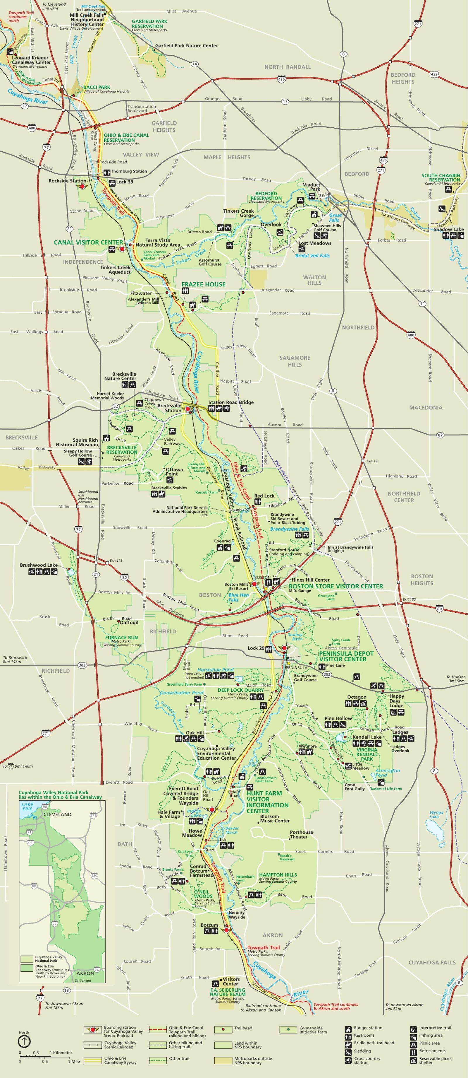
The official park map handed out at entrance stations, with roads, areas, visitor centers and services. View it here or download it for offline use.
Download the map (PDF) Public domain · National Park ServiceWhere Is Cuyahoga Valley?
Cuyahoga Valley National Park lies in northeastern Ohio (OH), about 22 miles south of Cleveland and 19 miles north of Akron. On a map of the United States, look for the Great Lakes region. The park is a two-hour drive from the southern shore of Lake Erie. Its location between two major metro areas makes it one of the easiest national parks in the country to reach, with no international flight or long drive required. Routes from Cleveland and Akron, along with public transportation options, are covered in the Cuyahoga Valley access guide.
Download the Official Cuyahoga Valley Map (NPS Unigrid)
The National Park Service publishes its Unigrid map as a PDF. It covers the entire park and shows trails, visitor centers, trailheads, and areas subject to overnight closures. Download it free at nps.gov/cuva before you leave. Cell service can be unreliable in the valley bottom, so a printed copy is still your best backup. An offline app such as “Cuyahoga Valley Offline Map” is a useful addition to the paper map in the field.
Cuyahoga Valley Areas
The park is organized into three areas running from north to south, with the Cuyahoga River running through them end to end.
North Area (Valley View and Brecksville)
This is the gateway from Cleveland. It includes Station Road Trailhead, the first access point to the Towpath Trail, and Beaver Marsh. During a morning visit, I saw three great blue herons in less than an hour from the wooden boardwalk crossing the wetland. The terrain is flat and accessible, making it a good introduction to the park. The Cuyahoga Valley family outings guide lists the loops suited to this area.
Central Area (Peninsula and Boston Mill)
This is the park’s logistical hub. Boston Mill Visitor Center (6,947 Riverview Road, Peninsula) is the best starting point for a first visit, with paper maps, ranger advice, and direct access to the Towpath Trail. The Cuyahoga Valley Scenic Railroad serves this area from several stations. You can also take a vintage train through the wooded valley if you’d like to alternate walking with sightseeing. The Cuyahoga Valley activities guide lists all the activities available around Peninsula.
South Area (Brandywine, The Ledges, and Kendall Lake)
This is the area for hills and scenic highlights. Brandywine Falls, about 65 feet high, is the park’s most visited waterfall and is accessible in less than 0.9 miles from the parking area. The Ledges feature sandstone formations along the edge of the plateau. They’re less well known than Brandywine, but still worth the detour. Note that Brandywine Falls, The Ledges, Octagon, Kendall Lake, and Kendall Hills close from dusk until morning opening.
Park Entrances and Driving Through the Park
Cuyahoga Valley has no paid entrance gates. The park is open 24 hours a day, with no entrance fee. Riverview Road forms the north-south backbone and follows the Cuyahoga River from Valley View to the outskirts of Akron. Several cross roads, including Brandywine Road and Highland Road, connect the trailheads to I-77 and I-271. You can drive through the park from end to end in less than 45 minutes without stopping, but nobody does that.
Points of Interest and Scenic Overlooks on the Map
On the map, make these your priorities:
- Brandywine Falls: the iconic photo spot, busy by 8 a.m. during the season. Arrive early to avoid the crowds.
- Beaver Marsh (north area): sunrise is a good time to watch herons and beavers from the boardwalk.
- Ledges Overlook: a view over the canopy from the plateau’s sandstone formations.
- Happy Days Lodge: a 1930s CCC building, a useful landmark on the map and a picnic spot.
The Cuyahoga Valley hiking guide locates every trailhead and gives its distance, elevation gain, and difficulty level.
Nearest Cities and Airports
Two cities frame the park: Cleveland to the north, about 22 miles away, and Akron to the south, about 19 miles away. The small town of Peninsula sits within the park itself, just steps from Boston Mill Visitor Center. For flights, keep two airports in mind: Cleveland Hopkins International Airport (CLE) and Akron-Canton Regional Airport (CAK). Our Access & Transportation guide compares rental car options and routes from each terminal.
Hiking Maps and Topographic Guides
The NPS Unigrid map is enough for the vast majority of visitors. If you want a map with contour lines and secondary trailheads, Trails Illustrated (National Geographic Maps) publishes a 1:40,000 map covering Cuyahoga Valley. You can find it at a specialty travel bookstore or order it before you leave.
Frequently Asked Questions
What are the most popular waterfalls in Cuyahoga Valley National Park?
The most popular waterfall in Cuyahoga Valley is Brandywine Falls, which is about 65 feet high and visible from a boardwalk overlooking the gorge. The round-trip trail is less than 0.9 miles from the dedicated parking area.
Is there a scenic road through Cuyahoga Valley National Park?
Riverview Road is the main road through the park, running north to south along the Cuyahoga River. For a more scenic crossing, the Cuyahoga Valley Scenic Railroad offers vintage train rides through the wooded valley, a route you can’t otherwise experience except on foot.
What city is near Cuyahoga Valley National Park?
Cleveland is the nearest city to the north, about 22 miles away, and Akron is about 19 miles to the south. The town of Peninsula sits within the park itself, just steps from the main visitor center.