
Biscayne National Park Map: 95% Water, Here's How to Read It
Biscayne National Park lies in Florida, about 25 miles south of Miami. Its layout is striking on any map: 95% of the park is underwater, spanning Biscayne Bay, a chain of small islands called the Keys, and offshore coral reefs. The official NPS map is available as a free PDF on the National Park Service website (nps.gov/bisc, under “Maps”). Download it before you leave because cell service fades quickly once you're on the water.
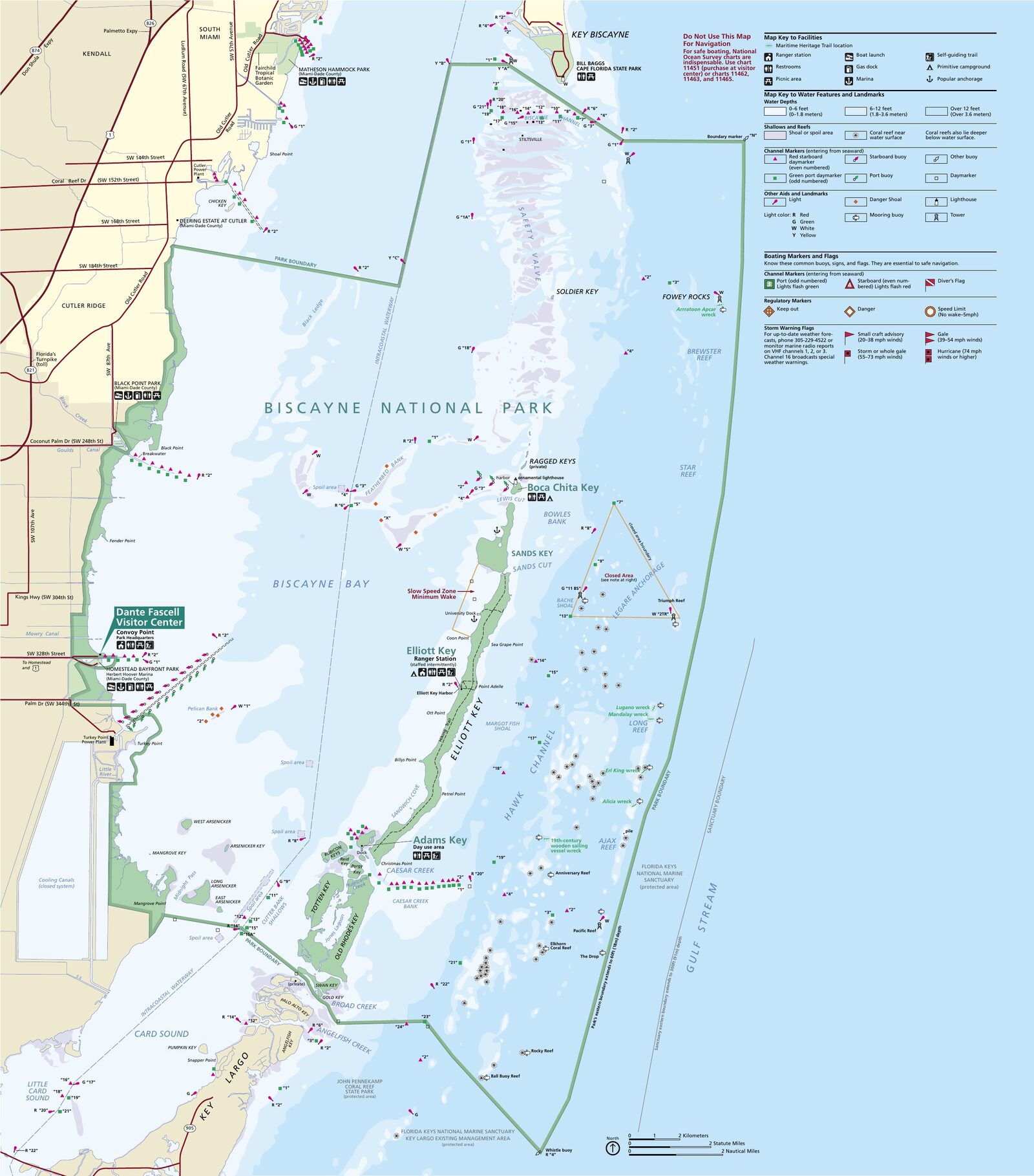
The official park map handed out at entrance stations, with roads, areas, visitor centers and services. View it here or download it for offline use.
Download the map (PDF) Public domain · National Park ServiceWhere Is Biscayne National Park?
Biscayne sits in Florida's far southeastern corner, in Miami-Dade County. It borders Everglades National Park to the west and stretches south toward the Florida Keys. The park's only mainland access point, Convoy Point, is in Homestead, about 25 miles south of downtown Miami.
One useful clarification: Biscayne is often confused with Key Biscayne, an upscale residential municipality in Miami-Dade known for its tennis courts and beaches. They are two separate entities with no administrative connection. The national park itself has been a federally protected area managed by the National Park Service since 1980.
Our complete Biscayne guide puts the park in its regional context and gives you the big picture before getting into the details.
Download the Official Biscayne Map (NPS Unigrid)
The NPS publishes a free “Unigrid” map for every park. The Biscayne map shows the bay, the Keys, reef areas, and zones with special regulations, including restricted boating and a ban on anchoring on coral. It also marks mooring buoys and the camping areas on Elliott Key.
To download it, go to nps.gov/bisc and follow the “Maps” link in the “Plan Your Visit” section. The PDF is free to access. Print a copy, too. On a kayak in wind and spray, a laminated sheet beats a touchscreen.
Biscayne's Zones
The official map divides the park into four clearly distinct zones.
Convoy Point and the Mainland Shore
Convoy Point is the only part of the park you can reach by car. It is home to the Dante Fascell Visitor Center, with a park museum, film screenings, an art gallery, and a terrace overlooking the bay. A boat ramp lets you launch kayaks and canoes from the parking area, while the jetty walkway follows the breakwater out toward open water.
Biscayne Bay
This broad, shallow lagoon stretches between the mainland and the Keys. Turquoise water, seagrass beds, stingrays, and sea turtles make it ideal for kayaking, paddleboarding, and surface snorkeling. Winds can pick up, so check the marine forecast before heading out.
The Keys (Islands)
Elliott Key is the park's largest island and the only one with a campground and restrooms. Boca Chita Key is home to a historic 1930s lighthouse, one of the park's most photographed spots. Adams Key offers picnic tables for daytime use. You can reach all three islands only by boat. No mainland road connects to them.
The Coral Reefs (Offshore Zone)
The park's eastern edge protects some of the northernmost coral reefs along the U.S. Atlantic coast. Divers and snorkelers find an unusually rich variety of marine life here. Regulations are strict: reduced speeds are required, and anchoring on the reef is prohibited. Marked mooring buoys protect the coral formations.
Getting to the Park and Boating
You can't cross Biscayne by car. Every marine zone, including the bay, Keys, and reefs, is accessible only by boat. Mainland access ends at Convoy Point. To reach the Keys or reefs, you can bring your own boat and use the on-site ramp, or book a trip with an authorized operator departing from Convoy Point.
To reach Convoy Point from Miami, allow about 40 minutes via the Florida Turnpike. For boat shuttles and rentals in Homestead, see the Biscayne access guide.
Points of Interest on the Map
Before you head out on the water, locate these landmarks on your map:
- Dante Fascell Visitor Center: information, boat launch, and departure point for guided trips.
- Elliott Key Harbor: mooring, campground, and a coastal trail along the island's western shore.
- Boca Chita Key: historic lighthouse, mooring, and picnic area.
- Adams Key: daytime picnicking, fresh water, and snorkeling from the dock.
- Maritime Heritage Trail: six marked shipwrecks underwater. Guided diving is recommended for beginners.
For a detailed schedule of activities in each zone, see our Things to Do in Biscayne page.
Nearest Towns and Airports
Homestead is the gateway town for the park, about 9 miles from the visitor center. You'll find hotels at every price point, boat rentals, supermarkets, and gas stations, all useful before a night camping in the Keys.
Miami is the nearest major city, 25 miles to the north. Miami International Airport (MIA) is about 31 miles from the park, while Fort Lauderdale-Hollywood International Airport (FLL) is an alternative about 43 miles away. Our Access & Transportation page covers connections from both airports. For lodging in the area, our Biscayne lodging guide lists options from Homestead to Miami.
Hiking Maps and Paper Guides
Land trails are limited to Elliott Key and Convoy Point. Biscayne is primarily a marine park. A few resources are useful alongside the official map when you're planning time on the water:
- Waterproof Charts (a specialized American publisher): laminated nautical charts for navigating the bay and reefs.
- Florida Keys Paddling Guide (Menasha Ridge Press): detailed kayak routes covering Biscayne's waters.
- Lonely Planet Florida: regional background and practical sidebars, useful when combining the trip with Everglades National Park or the Keys.
You can order these books online. The park has no specialty shop.
Frequently Asked Questions
Where is Biscayne National Park?
Biscayne National Park is in Miami-Dade County, Florida, about 25 miles south of downtown Miami. Its main entrance is at Convoy Point in Homestead.
Where is Biscayne Bay?
Biscayne Bay stretches between Florida's mainland east coast and a chain of small islands called the Keys. It makes up most of Biscayne National Park, east of Miami, separated from the Atlantic Ocean by the Keys.
Can you drive across Biscayne?
No. Nearly the entire park is underwater. Mainland access is limited to the Dante Fascell Visitor Center at Convoy Point. You need a boat to reach the Keys and reefs.
What is the closest town to Biscayne?
Homestead is the closest town to Biscayne National Park, about 9 miles from the visitor center. Miami is the nearest major city, 25 miles to the north.
How much does it cost to enter Biscayne National Park?
Admission to Biscayne National Park is free. For entrance fees and annual passes, see the National Parks Fees & Passes page.
How long do you need to visit Biscayne?
Half a day is enough for Convoy Point and a kayaking trip on the bay. Allow a full day to reach Elliott Key, and at least two days to explore the reefs and spend the night on the island. Our Biscayne itineraries offer plans for different amounts of time.