

Acadia Map: Layout, Areas, and the Official Map to Download
Acadia National Park lies in Maine on the northeastern coast of the United States, primarily on Mount Desert Island. About 174 miles north of Boston and 56 miles southeast of Bangor, it's a compact coastal park covering 73 square miles, with granite, forest, and ocean landscapes. The official NPS map is available as a free download from the National Park Service website (nps.gov/acad).
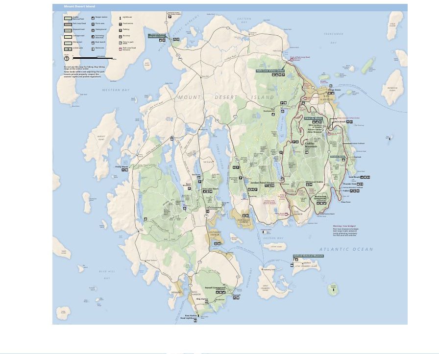
The official park map handed out at entrance stations, with roads, areas, visitor centers and services. View it here or download it for offline use.
Download the map (PDF) Public domain · National Park ServiceWhere Is Acadia?
Acadia occupies several separate areas in Maine, the northeasternmost state in the United States. The heart of the park is on Mount Desert Island, a coastal island connected to the mainland by a bridge at Ellsworth. Two other areas complete the park: Schoodic Peninsula, the only section on the mainland, and Isle au Haut, accessible only by ferry. This is New England, about a day's drive from New York. To place Acadia in its regional context and see how it fits into an East Coast road trip, check out our regional guide.
The Official Acadia Map (NPS Unigrid) to Download
The NPS publishes its “Unigrid” map as a free PDF. It covers all three areas of the park, including roads, marked trails, visitor centers, campgrounds, and the main points of interest. We consider it essential before you head out because the trail network is dense, and signs in the park aren't always enough to help you find your way. Download it directly at nps.gov/acad/planyourvisit/maps.htm.
Acadia's Areas
Acadia is divided into three distinct geographic areas.
Mount Desert Island (Main Area)
This is where most visitors spend their time. You'll find Park Loop Road, Cadillac Mountain (1,530 feet, the highest point on the Atlantic coast of the United States), Jordan Pond, Sand Beach, and Thunder Hole. The area has two distinct sides: the Bar Harbor side to the east, which is busier, and the “Quiet Side” to the southwest, which is much calmer and often overlooked by visitors in a hurry.
Schoodic Peninsula
About 37 miles northeast of Bar Harbor by road, or reachable by seasonal ferry, Schoodic is the only part of Acadia on the mainland. A one-way road loops around the peninsula, with wide-open views of the Atlantic. It's a good way to avoid the crowds on the main island in July and August.
Isle au Haut
This is the park's wildest area. The island lies offshore from Stonington and is accessible only by ferry, a 45-minute ride from Stonington. Trails are lightly marked, camping is very limited, and reservations are required. We recommend it for hikers looking for true solitude.
Park Entrances and Park Loop Road
Acadia doesn't have a single entrance gate. The main visitor facility is the Hulls Cove Visitor Center, north of Mount Desert Island and the starting point for Park Loop Road. This 27-mile road loops around the island's eastern side and reaches nearly all of the major sites. It is partly one-way between Sand Beach and Otter Cliff.
During the peak season, from late May through October, access to Park Loop Road requires a timed entry reservation. It costs $6 per vehicle in addition to the entrance fee. The vehicle pass costs $35, and the annual Acadia pass costs $70. For transportation options and distances from major cities, see how to get to Acadia.
Points of Interest and Viewpoints on the Map
Mark these spots on your map before you go.
Cadillac Mountain (1,530 feet): from early October to early March, this is the first place in the United States to see the sunrise. You can reach it by car or by several marked trails.
Thunder Hole: a rocky fissure on the east coast where waves rush in with a roar. The best effect comes about two hours before high tide.
Sand Beach: one of the park's few sandy beaches, framed by granite cliffs. The water is around 54°F in summer, so swimming is for the brave.
Jordan Pond: a glacial lake with views of the two hills known as “The Bubbles.” Jordan Pond House has served homemade popovers for more than a century, making it a local institution you shouldn't miss.
Bass Harbor Head Lighthouse: a lighthouse on the island's southwest coast, especially popular with photographers at sunset.
For details on activities in each area, the Things to Do in Acadia and Acadia Hiking guides cover every site. Opening hours and entrance fees are listed in the park guide.
Nearest Towns and Airports
Bar Harbor (about 5,500 residents) is the main gateway. It borders the park, has the largest concentration of lodging and restaurants, and provides ferry connections to Schoodic Peninsula and Isle au Haut. The closest airports are Bangor (BGR, 56 miles) and Portland (PWM, 118 miles). From Boston, plan on about three hours of driving. Our Access & Transportation page covers distances and options from each entry point. For lodging in and around Bar Harbor, see places to stay near Acadia.
Hiking Maps and Printed Trail Guides
The NPS Unigrid map is enough for a general visit. For serious hiking, two references are widely regarded as authoritative.
National Geographic Trails Illustrated No. 212 (Mount Desert Island): 1:30,000-scale mapping, rated and numbered trails, and water-resistant material. Available from cartovia.com and specialty bookstores (librairie-voyage.com).
AMC Acadia National Park Hiking Guide (Appalachian Mountain Club): elevation profiles and detailed trail-by-trail descriptions, ideal for planning a week of hiking.
Frequently Asked Questions
Where is Acadia on the map?
Acadia is in Maine on the northeastern coast of the United States, primarily on Mount Desert Island, about 174 miles north of Boston.
Where is Acadia?
Acadia is in the state of Maine, at the northeastern tip of the United States. The main area is on Mount Desert Island, a coastal island connected to the mainland by a bridge at Ellsworth.
Is there an official Acadia map to download?
Yes. The NPS offers its Unigrid map as a free PDF at nps.gov/acad/planyourvisit/maps.htm. It covers all three areas of the park and all marked trails.
Can you drive across Acadia?
Yes. Park Loop Road (27 miles) connects the main sites in the Mount Desert Island area. Part of the road is one-way between Sand Beach and Otter Cliff. During the peak season, a timed entry reservation ($6) is required to access Park Loop Road.
How large is Acadia National Park?
Acadia covers about 47,000 acres (73 square miles), making it a compact park compared with the major parks of the American West. Its small size is an advantage: the main sites are clustered together and accessible in a single day.
What is the closest town to Acadia?
Bar Harbor is the closest town and the park's main gateway. You can reach it directly from the Hulls Cove Visitor Center, north of Mount Desert Island.
What are the best things to see in Acadia?
The key sites to mark on your map are Cadillac Mountain, Thunder Hole, Sand Beach, Jordan Pond, and Bass Harbor Head Lighthouse. Our Things to Do page covers each site with visiting tips and suggested time.
How long do you need to visit Acadia?
Plan on two to four days to cover the main sites. For a day-by-day plan, see Acadia's detailed itinerary.