
Voyageurs National Park Map: Layout, Areas, and Official Map Download
Voyageurs National Park lies in northern Minnesota along the Canadian border with Ontario. The park stretches across four major lakes: Rainy Lake, Kabetogama Lake, Namakan Lake, and Sand Point Lake. The official NPS Unigrid map is available free at nps.gov/voya under “Maps.”
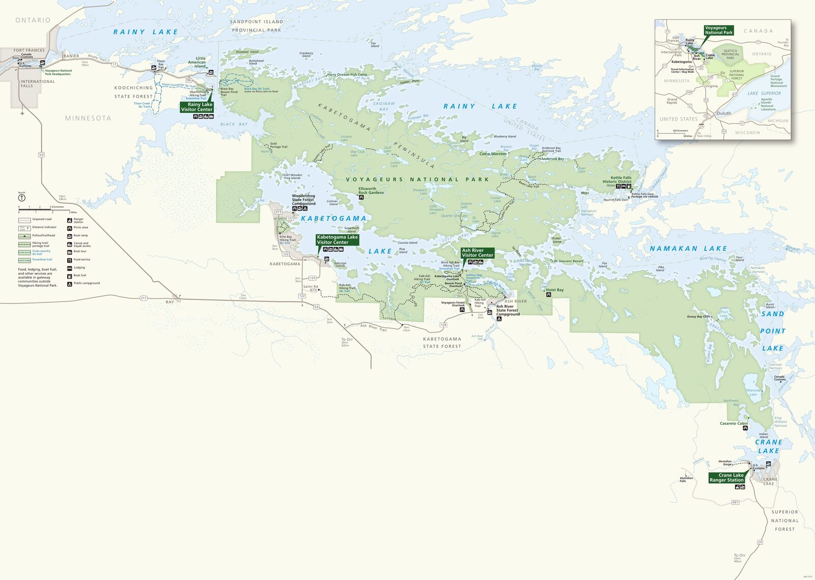
The official park map handed out at entrance stations, with roads, areas, visitor centers and services. View it here or download it for offline use.
Download the map (PDF) Public domain · National Park ServiceWhere Is Voyageurs National Park?
Voyageurs is in Koochiching County, northern Minnesota, about 25 miles east of International Falls. The Ontario border follows the park’s northern edge, and several islands lie in international waters.
The park is part of the Northern Great Lakes region. From Minneapolis, plan on about a 5-hour drive covering 300 miles. From Duluth, it’s 175 miles, or roughly 3 hours.
One number tells you a lot about the park: 40% of its area is water. You can reach the interior only by boat in summer or by snowmobile across the ice in winter. For travel logistics, see the guide to reaching the park.
Download the Official Voyageurs Map (NPS Unigrid)
The National Park Service publishes the park’s Unigrid map free of charge. It shows the four lakes, roughly 500 islands, moorings, land trails, and camping areas spread across the park.
To download it, go to nps.gov/voya and click “Plan Your Visit,” then “Maps.” The PDF is high-resolution and printable.
Here’s a practical tip: print the map before you leave. The park’s central areas have no cell service, and navigating the lakes without clear reference points can quickly become tricky.
Voyageurs’ Areas
The park is divided into four lake basins, each accessible from a separate entrance point.
Rainy Lake
The park’s largest lake sits in the northwest and is accessible from International Falls via US-11. The Rainy Lake Visitor Center, open during the warmer months, is 12 miles east of town. This is the park’s most developed area, with a marina, houseboat rentals, and land-hiking trailheads leading to overlooks along the shore.
Kabetogama Lake
This central area is accessible from US-53 and is home to a second visitor center. Its waters are less exposed to wind than Rainy Lake, while sandy beaches and islands close to shore make it popular with families. Our Family Guide covers the area in detail.
Namakan Lake and Sand Point Lake
These two lakes make up the eastern part of the park, linked by straits and islands. You can enter from Ash River, via the eastern turnoff from US-53, or from Crane Lake. This area has the park’s multi-day kayaking routes and isolated moorings far from any infrastructure.
Crane Lake
This southeastern entry point meets the Boundary Waters Canoe Area Wilderness. It has fewer services than Rainy Lake, but it’s a good way to reach the park’s interior waters from the Orr area. Our Hiking page covers the land trails that start in this area.
Park Entrances and Getting Around
No road crosses Voyageurs’ interior, so you can’t drive into the central areas. Drive to one of the five coastal access areas, then continue by water.
Road access points:
- Rainy Lake, from International Falls via eastbound US-11
- Kabetogama Lake, from US-53 on the west side
- Ash River, via the eastern turnoff from US-53
- Crane Lake, from Orr via an eastern secondary road
- Orr / Pelican Lake, north on US-53
Each access point has a parking lot and a boat launch. The park is open 24 hours a day, year-round, while the visitor centers close in the off-season. Our Getting Around page explains boat-rental options and navigation rules inside the park.
Points of Interest and Scenic Overlooks
Ellsworth Rock Gardens, in the Kabetogama area, is one of the park’s most photographed sites. The sculpture garden and plantings were developed on an island between 1944 and 1965, and you can reach them only by boat. When we visited in August, kayaking from the Kabetogama marina to the gardens took 30 minutes.
The Oberholtzer Trail in the Rainy Lake area climbs to rocky overlooks above the lake and the Canadian border. The elevation gain is moderate, but you’ll earn the view after 1.9 miles.
Voyageurs has been an International Dark Sky Park since 2020. On clear nights, you’ll find an exceptionally open horizon. Our Things to Do page pinpoints the best stargazing spots on the map.
Nearest Towns and Airports
International Falls (INL), 25 miles west, is the closest gateway to the Rainy Lake area. Duluth (DLH), 175 miles away and about 3 hours by car, and Minneapolis–Saint Paul (MSP), a 5-hour drive, offer more connections. Our guide to reaching the park lays out routes from all three cities.
Hiking Maps and Trail Guides (Print)
The NPS Unigrid map covers the entire park but doesn’t show land trails at hiking scale. For hiking trips, the National Geographic Trails Illustrated map (series 751, Boundary Waters / Voyageurs) includes contour lines and moorings.
You can find these maps at specialty travel bookstores or order them online before your trip. Our complete park guide lists additional practical resources.
Frequently Asked Questions
Where is Voyageurs National Park?
Voyageurs National Park is in northern Minnesota, about 25 miles east of International Falls along the Canadian border with Ontario.
Is there an official Voyageurs map available for download?
Yes. The National Park Service provides the Unigrid map as a free PDF at nps.gov/voya under “Plan Your Visit” / “Maps.”
Can you drive across Voyageurs?
No. There are no roads inside the park, and the central areas are accessible only by boat in summer or by snowmobile across the ice in winter.
What’s the closest town to Voyageurs?
International Falls, Minnesota, is the closest town, 25 miles west of the Rainy Lake Visitor Center.
How long do you need to visit Voyageurs?
It depends on how you visit and which areas you explore. Our Itinerary and Length page offers 1- to 5-day scenarios.
Where’s the best place to get an overview of the park?
The overlooks along the Oberholtzer Trail in the Rainy Lake area and the islands of Kabetogama offer representative views of the lake country. Our Things to Do page points out others based on how you’re getting around.