
North Cascades Map: Regions, Routes, and the Official Map
North Cascades National Park is in Washington State, in the northwestern United States along the Canadian border. The main road, SR 20 (North Cascades Highway), crosses the complex from west to east, running from Burlington to the junction with US 97. The official NPS map is available free on the park website. Download it before you go, because cell service is nearly nonexistent in the canyons.
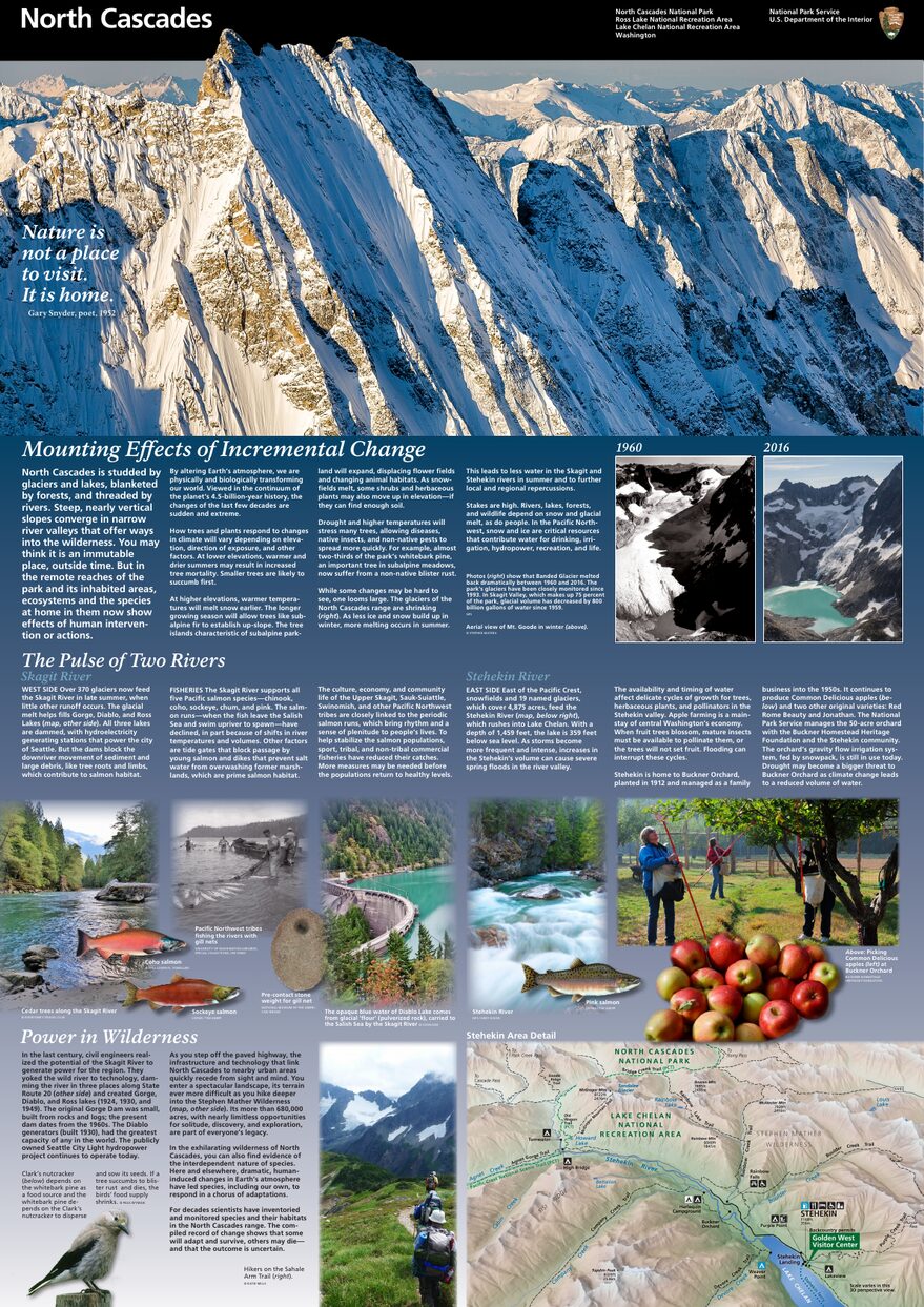
The official park map handed out at entrance stations, with roads, areas, visitor centers and services. View it here or download it for offline use.
Download the map (PDF) Public domain · National Park ServiceWhere Is North Cascades?
North Cascades is in the northwestern part of Washington State, about 100 miles northeast of Seattle, directly south of the British Columbia border. On a map of the United States, the park sits in the Cascade Range, between the Pacific coast and the inland Great Plains.
The North Cascades National Park Service Complex includes three distinct units: the national park itself, with its northern and southern units, Ross Lake National Recreation Area, and Lake Chelan National Recreation Area. Together, they cover more than 1,000 square miles, an area comparable to Corsica, and receive fewer than 30,000 visitors a year.
For an overview of the region, our complete North Cascades guide covers the basics. Routes from Seattle or Vancouver are detailed in the park access guide.
Downloading the Official North Cascades Map (NPS Unigrid)
The Unigrid map published by the National Park Service is the free go-to reference. It covers the entire complex, including paved roads, main trails, campgrounds, visitor centers, and the boundaries of all three units. You can download it from the Maps page on the NPS website (nps.gov/noca/planyourvisit/maps.htm).
Print it on letter-size paper before you leave. In remote areas such as Stehekin and Ross Lake, there is no cell service and no bookstore where you can pick one up.
North Cascades Regions
Ross Lake National Recreation Area
This is the central corridor of the complex, crossed by SR 20. It includes Diablo and Ross lakes, Gorge Dam, the village of Newhalem, and the main visitor center. Most visitors pass through here, often without realizing it. Ross Lake NRA is not technically the national park, but it is the main road corridor.
North Cascades National Park (Northern and Southern Units)
The two units of the national park itself border Ross Lake NRA to the north and south. You can barely reach them by car. Only a few trailheads provide access on foot. This is rugged country for experienced hikers and mountaineers. More than 300 glaciers are found here, making it one of the most heavily glaciated areas in the contiguous United States.
Lake Chelan National Recreation Area
This unit is physically separated from the rest of the complex. You can reach it only by ferry from the town of Chelan, a four-hour trip across the lake, or by seaplane. It is home to the community of Stehekin, a bucolic outpost at the far end of Lake Chelan. The atmosphere is completely different here, with a drier, warmer climate on the east side and summers that can top 90°F.
Entrances and Driving Across the Complex
SR 20 (North Cascades Highway) is the only road that crosses the complex. To the west, it connects with I-5 in Burlington at Exit 230. To the east, it intersects US 97. There is no internal loop, so you enter at one end and leave at the other.
One important point: SR 20 closes in winter between Diablo and Mazama, generally from October through April, because of avalanche danger. Check road conditions on the Washington State DOT (WSDOT) website before you leave.
There is no entrance fee to drive through the SR 20 corridor and Ross Lake NRA.
Map Highlights and Scenic Viewpoints
Here are four landmarks to identify on your map before you hit the road:
- Diablo Lake Overlook: a lake known for its turquoise water, accessible from a roadside viewpoint along SR 20.
- Washington Pass Overlook: at 5,480 feet, with views of the granite spires of the Early Winters Spires. The winding climb is as worthwhile as the view at the top.
- Newhalem: a starting point for short family-friendly trails, with the North Cascades visitor center. It is an ideal place to get oriented at the start of your visit.
- Stehekin: a mark at the far end of Lake Chelan on the map, representing a remote community with no land-access road in reality.
Our Things to Do in North Cascades page covers the trails, times, and difficulty levels from each of these points.
Nearest Towns and Airports
To the west, Burlington, at the I-5/SR 20 junction, is the main gateway from the coast. Bellingham (BLI) is about 1.5 hours away, and Seattle-Tacoma International Airport (SeaTac) is 2.5 to 3 hours away. To the east, Winthrop, about 12 miles from Washington Pass, is the ideal base for the eastern side. Spokane (GEG) is 3.5 hours away. For detailed routes, car rentals, and seasonal shuttles, see our Access & Transportation page.
Hiking Maps and Paper Guidebooks
For trails away from the SR 20 corridor, the NPS Unigrid map is not enough. Here is what we take into the field:
- Green Trails Maps: the go-to choice for local hikers, sold at the Newhalem visitor center and at specialty bookstores such as Cartovia and ITM.
- Tom Harrison Maps: laminated topographic maps at a 1:50,000 scale, available by special order.
- North Cascades Offline Map (Google Play/App Store): an offline digital option that is useful as a supplement.
The park's northern and southern units require serious topographic navigation. Trails are lightly marked and the terrain is alpine. Our Hiking page lists trails by region and difficulty.
Frequently Asked Questions
Where is North Cascades on a map of the United States?
North Cascades National Park is in Washington State, in the northwestern United States, about 100 miles northeast of Seattle and directly south of the Canadian border.
Is there a North Cascades map? Can I download it?
Yes. The official NPS Unigrid map is available free on nps.gov/noca under “Maps.” Download it before you leave because cell service is very limited in the park.
Can you drive across North Cascades?
Yes. SR 20 (North Cascades Highway) crosses the complex from west to east. Keep in mind that the road closes between Diablo and Mazama in winter, generally from October through April, because of avalanches.
What is the best viewpoint in North Cascades?
Diablo Lake Overlook and Washington Pass Overlook are the two most accessible viewpoints along SR 20, and neither requires a hike. Our Things to Do page lists more, along with the required difficulty levels.
How long do you need to visit North Cascades?
Driving SR 20 across the complex takes half a day. A full visit that includes Stehekin takes several days. Our Itineraries & Timing page offers plans tailored to the time you have available.
What is the closest town to North Cascades?
To the west, Burlington, at the I-5/SR 20 junction, is the closest gateway. To the east, Winthrop is the most pleasant base for exploring the eastern side of the park.