
New River Gorge Map: Park Areas, Official Map, and Directions
New River Gorge National Park & Preserve is in West Virginia, in the Southern Appalachians, about 62 miles south of Charleston. You can download the official NPS Unigrid map as a free PDF from the NPS website. Keep it with you because cell service is unreliable deep in the gorge.
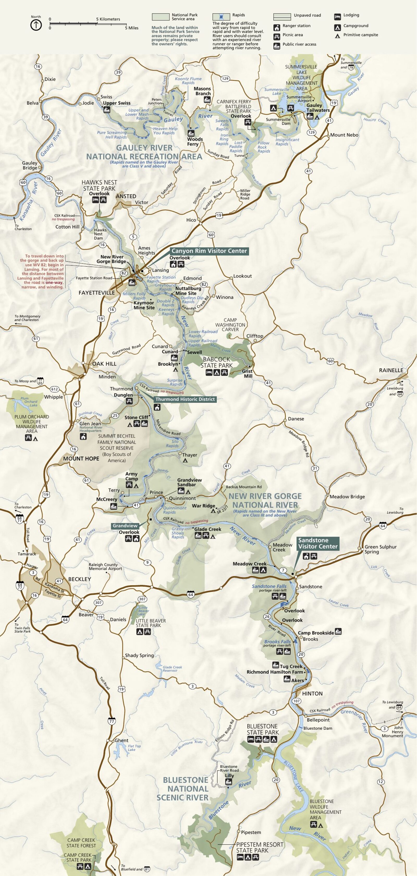
The official park map handed out at entrance stations, with roads, areas, visitor centers and services. View it here or download it for offline use.
Download the map (PDF) Public domain · National Park ServiceWhere Is New River Gorge?
New River Gorge stretches for more than 50 miles through the Southern Appalachians in southern West Virginia. The New River carved a canyon here that drops more than 1,000 feet into the coal-bearing plateaus.
The park covers Fayette, Nicholas, Raleigh, and Summers counties. It lies in the broader Southern Appalachian region, between the Blue Ridge to the east and the Cumberland Plateau to the west.
Here's a geological fact worth knowing: the New River is one of the oldest rivers in North America. It flows north, contrary to what you might expect, toward the Kanawha and then the Ohio.
Download the Official New River Gorge Map (NPS Unigrid)
The NPS publishes the Unigrid map as a free PDF. It combines a general park map, close-ups of recreation areas, a table of available services, and road references.
Download it at nps.gov/neri/planyourvisit/maps.htm (public domain, updated regularly). Print it before you leave because cell service isn't guaranteed in the deep gorges.
Canyon Rim and Sandstone visitor centers also hand out free folded paper copies at the front desk.
New River Gorge Areas
The park is divided into four geographic areas from north to south. Each has its own character and main activities.
Canyon Rim (north)
This is the main entrance, and the most accessible and busiest area. The Canyon Rim visitor center is open daily from 9 a.m. to 5 p.m. (closed on Thanksgiving, Christmas, and New Year's Day). An overlook at the edge of the cliff looks down on New River Gorge Bridge, one of North America's great steel arches, 876 feet above the river.
Thurmond (central)
The former mining town of Thurmond clings to the bottom of the gorge and is reached by a narrow road. This is the park's historic area, with early-20th-century buildings, the former Chesapeake & Ohio Railway station, and tracks still in place. The seasonal visitor center is open from Memorial Day through Labor Day.
Grandview (southeast)
Grandview sits on the plateau rim at about 2,950 feet above sea level. It offers the clearest views of the river's bends below. The seasonal visitor center is accessible from Route 9. It's an ideal spot for summer sunsets.
Sandstone (south)
Sandstone is the park's southern entrance, near the town of the same name. The Sandstone visitor center is open year-round from 9 a.m. to 5 p.m. This area provides access to the lower, calmer section of the river, which is well suited to family boating.
Park Entrances and Driving Through the Park
There is no fee gate to pass through. Entrance to the park is free. The main route is Route 19, which crosses the park from north to south and crosses the famous bridge 876 feet above the river.
To reach Park Headquarters, take Route 19 North from Beckley to the Glen Jean exit. At the exit, turn immediately left, then right at the next intersection. Park Headquarters is straight ahead.
Fayette Station Road descends in tight switchbacks to the bottom of the gorge. Vehicles longer than 29 feet are prohibited, so check your vehicle's length before heading down. For driving distances and times from major cities, the New River Gorge access guide has all the key information.
Points of Interest and Overlooks on the Map
Here are a few landmarks to locate on your map before you go:
- New River Gorge Bridge: From the Canyon Rim overlook, it's the park's iconic image.
- Long Point Trail: A trail leading to a natural overlook facing the bridge, without the weekday crowds.
- Grandview Rim: A series of overlooks above the river's bends, especially spectacular in the fall.
- Fayette Station: At the bottom of the gorge, a starting point for whitewater activities.
The New River Gorge activities guide locates these spots and lists the must-see areas by section.
Nearest Towns and Airports
Fayetteville (in Fayette County) is the gateway town for the park, just a few miles from the Canyon Rim visitor center. You'll find hotels, restaurants, and outdoor gear outfitters there. The New River Gorge lodging guide covers options in Fayetteville, Beckley, and the park.
Beckley (about 19 miles south) is larger and has more everyday services. Raleigh County Memorial Airport (BKW) is in Beckley.
Charleston, the state capital, is about 62 miles north. Yeager Airport (CRW) has better national connections.
Paper Hiking Maps and Climbing Guides
The NPS Unigrid map is enough for a general visit to the park. If you're heading onto less-marked trails or exploring the sandstone cliffs as a climber, a 1:24,000 topographic map is useful.
Trails Illustrated (National Geographic) publishes a paper map covering New River Gorge. It's available from specialty travel booksellers (the travel bookstore and Omnimap shop) and online. It withstands rain and includes elevation contours.
For climbing, the standard guidebook is Handren and Horst's guide to New River Gorge. It covers the Bridge Area, Long Wall, and Meadow River areas with detailed route information. The New River Gorge trails guide adds to these resources with trails organized by difficulty.
Frequently Asked Questions
How long does it take to drive through the New River Gorge?
It takes less than 30 minutes to drive through the New River Gorge if you simply cross the bridge on Route 19. To stop at the main overlooks (Canyon Rim, Grandview, Fayette Station), allow a full half-day. The itinerary guide includes 1-, 2-, and 3-day New River Gorge itineraries.
What is the closest town to the New River Gorge?
The closest town to the gorge is Fayetteville, a few miles from the Canyon Rim visitor center. For a wider selection of lodging and stores, Beckley is about 19 miles south.
Can you download the official New River Gorge map for free?
Yes. The official NPS Unigrid map is freely available at nps.gov/neri. It's a printable PDF, and the paper copies at the Canyon Rim and Sandstone visitor centers are also free.
Is there a detailed hiking trail map?
The Unigrid map covers the main trails. For routes with contour lines and elevation information, National Geographic's Trails Illustrated map is the recommended tool. Our Hiking page lists trails by difficulty, along with their lengths and elevation gains.