
Mesa Verde Map: Park Areas, Layout, and Official Map Download
Mesa Verde National Park lies in southwestern Colorado, accessible via US 160, about 10 miles east of Cortez and 35 miles west of Durango. The official NPS PDF map, known as the Unigrid map, is available free on the National Park Service website. Here's how to read the park map, including its areas, entrances, viewpoints, and essential landmarks for planning your visit.
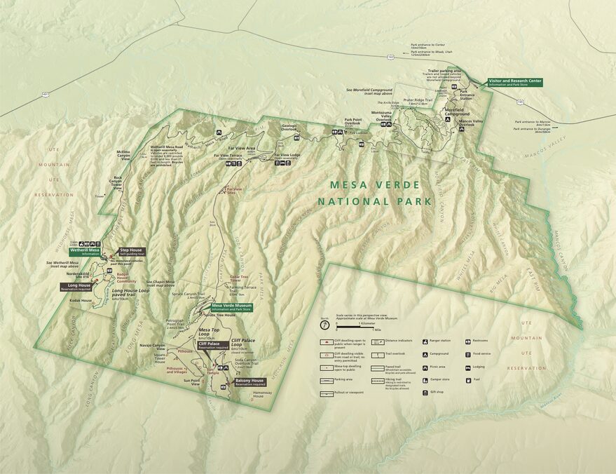
The official park map handed out at entrance stations, with roads, areas, visitor centers and services. View it here or download it for offline use.
Download the map (PDF) Public domain · National Park ServiceWhere Is Mesa Verde?
Mesa Verde occupies the southwestern corner of Colorado, in the Four Corners region where Colorado, Utah, Arizona, and New Mexico meet. On a map of the United States, the park lies between Cortez to the northwest and Durango to the northeast, perched on a forested plateau between 6,600 and 8,500 feet above sea level.
Mesa Verde is one of the few U.S. national parks created primarily to protect an archaeological site. It preserves some 5,000 Ancestral Puebloan sites, including dwellings built in cliff alcoves more than 700 years ago. Its mesa-and-canyon landscape of red sandstone gives it an instantly recognizable profile on any map of the region.
To place Mesa Verde in the broader context of the American Southwest, our Southwest region guides provide an overview of the major Four Corners destinations. Our complete Mesa Verde guide covers everything you need to know before you go.
Downloading the Official Mesa Verde Map (NPS Unigrid)
The National Park Service publishes the Mesa Verde Unigrid map as a free PDF in English. It covers the park roads, parking areas, two main areas, Chapin Mesa and Wetherill Mesa, archaeological sites open to the public, marked trails, and picnic areas. Download this basic map before you enter the park.
The free NPS app also offers an offline version for mobile devices. That's useful because cell service is unavailable across much of the plateau.
Mesa Verde's Park Areas
The park is divided into two distinct geographic areas. They aren't directly connected, so you'll need to return to the main road to travel from one to the other.
Chapin Mesa: The Park's Archaeological Heart
This is the central, most visited, and best-documented area. It includes the Chapin Mesa Archaeological Museum, which is free and open year-round, along with Spruce Tree House, visible from an overlook, Cliff Palace, and Balcony House. You can visit the latter two sites only on paid guided tours, which you should reserve in advance through the park.
Mesa Top Loop is a roughly 6-mile scenic drive linking several overlooks of surface ruins, including pit houses and kivas. Allow 10 to 20 minutes at each stop.
For details on activities and tours on Chapin Mesa, our Things to Do in Mesa Verde page is the best place to start.
Wetherill Mesa: The Quieter Western Area
Wetherill Mesa lies in the western part of the park, about 12 miles from the visitor center. It opens only in summer, from late May to early September, depending on conditions. Here you'll find Long House, the park's second-largest cliff dwelling, which requires a paid guided tour, and Step House, the only site open to visitors without a guide.
Far fewer people visit this area than Chapin Mesa. The canyon views are wide open, and the atmosphere feels distinctly different. The Badger House Community Trail, about 2.5 miles long, lets you explore surface ruins at your own pace.
Park Entrances and Driving Through the Park
Mesa Verde has just one official entrance, on US 160 between Cortez and Mancos. From the entrance, the main road climbs through a series of switchbacks for about 16 miles to the heart of the park.
The climb is steep and the turns are tight. RVs and vehicles towing trailers longer than 25 feet aren't allowed beyond Morefield Campground, 4.3 miles from the entrance. The speed limit is 35 mph on the main road and 25 mph in site and parking areas.
Mesa Verde is a geographic dead end. You enter and leave through the same entrance, and there's no road across the park from one end to the other. For vehicle restrictions, internal shuttles, and driving distances, the Mesa Verde access guide has all the details. Our Mesa Verde RV guide covers advice for RV travelers.
Points of Interest and Viewpoints on the Map
The NPS map distinguishes archaeological sites, including cliff dwellings, kivas, and towers, from panoramic overlooks. These are the most useful landmarks for planning your route:
- Park Point: the park's highest point at 8,570 feet, with 360-degree views across all four Four Corners states. Drive there from the main road, then walk 500 feet from the parking area.
- Cliff Palace Overlook: a sweeping view down into the canyon toward Cliff Palace before the descent for the guided tour.
- Sun Temple Overlook: a view of the canyon from the opposite side of Cliff Palace, usually with fewer visitors.
- Montezuma Valley Overlook: a west-facing panorama over the Cortez plain and the mountain ranges of Utah.
Our Mesa Verde hiking guide covers the marked trails, including their profiles and durations. Find guided tours and other activities on our Things to Do in Mesa Verde page.
Nearest Towns and Airports
On a regional map, Mesa Verde sits within a triangle formed by three Colorado towns:
- Cortez: 10 miles west of the entrance, it's the main gateway town. Supermarkets, gas stations, hotels, and car rentals are concentrated here.
- Mancos: 9 miles east of the entrance. It's a quieter town with a few places to stay and restaurants.
- Durango: 35 miles east. It's the region's largest city, with Durango-La Plata County Airport (IATA code: DRO), served by flights from Denver, Phoenix, and Dallas, among other cities.
For flights, car rental options, and driving times from major cities, our Access & Transportation page provides the practical details. Our Where to Stay in Mesa Verde guide covers accommodations in Cortez, Mancos, and the park.
Paper Hiking Maps and Trail Guides
The NPS Unigrid map does a good job covering the roads and main sites, but it isn't enough for hiking beyond the marked routes. Here are two reliable options:
- Trails Illustrated No. 505 (National Geographic): a 1:35,000-scale topographic map of Mesa Verde, with trail details, contour lines, and field annotations. Available at specialty travel bookstores.
- Laminated maps (Cartovia, ITM): moisture-resistant and practical for everyday use in the field.
These paper maps remain useful even with a smartphone, especially for reading the terrain and anticipating elevation changes across the plateau.
Frequently Asked Questions
What is Mesa Verde?
Mesa Verde National Park is a U.S. national park in Colorado, established in 1906 and designated a UNESCO World Heritage Site. Its defining feature is the preservation of some 5,000 Ancestral Puebloan archaeological sites, including dwellings built in cliff alcoves more than 700 years ago.
How much does it cost to enter Mesa Verde National Park?
The entrance fee is $30 per private vehicle, valid for 7 days, $25 for a motorcycle, and $15 per pedestrian or bicyclist. Guided tours of Cliff Palace, Balcony House, and Long House cost extra. For entrance fees and annual passes, see the National Park Entrance Fees & Passes page.
How do you visit Mesa Verde?
You visit Mesa Verde in a private vehicle from the entrance on US 160. You can visit the major archaeological sites on foot, on a paid guided tour, or independently, depending on the site. Our Mesa Verde itineraries offer routes tailored to the time you have available, whether that's one day, two days, or longer.
What country and state is Mesa Verde in?
Mesa Verde is in the United States, in Colorado, in the southwestern part of the country. The park is in the Four Corners region, where Colorado, Utah, Arizona, and New Mexico meet.
What is the closest town to Mesa Verde?
Cortez, Colorado, is the closest town, about 10 miles from the park entrance via US 160. The nearest airport is Durango-La Plata County Airport (DRO), about 35 miles east.
Can you drive across Mesa Verde?
No. Mesa Verde is a geographic dead end with one entrance on US 160. You enter and leave through the same access road. Inside the park, however, you can drive the main road and take Mesa Top Loop on Chapin Mesa.