
Indiana Dunes Map: Layout, Areas, and the Official Map
Indiana Dunes stretches for about 25 miles along the southern shore of Lake Michigan in northern Indiana. The park isn't one continuous block. Several areas, separated by lakeside communities, make up the whole park, so it's less straightforward to read than a single-block park in the West. The official NPS map is a free PDF you can download from the National Park Service website under “Maps.” Take a minute to save it before you leave. For an overview of everything the park offers, our complete Indiana Dunes guide is the place to start.
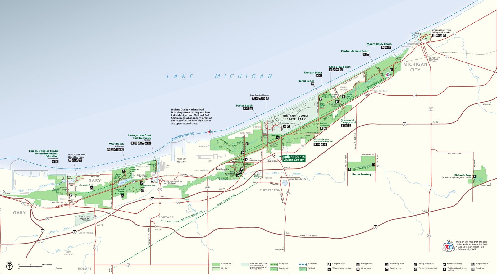
The official park map handed out at entrance stations, with roads, areas, visitor centers and services. View it here or download it for offline use.
Download the map (PDF) Public domain · National Park ServiceWhere Is Indiana Dunes?
Indiana Dunes National Park sits in northern Indiana, on the southern shore of Lake Michigan, between Gary to the west and Michigan City to the east. It's part of the Great Lakes region and borders Indiana Dunes State Park, a separately managed state property that fits within its boundaries.
The park covers about 23 square miles in total, spread across several noncontiguous units. Chicago is about 50 miles to the west, making Indiana Dunes one of the most accessible U.S. national parks from a major city. Our Great Lakes region guide places the park in the context of nearby sites.
Downloading the Official Indiana Dunes Map (NPS Unigrid)
The NPS Unigrid map is the reference document for planning your visit. It shows the federal areas, identifies beaches, trailheads, and access roads, and distinguishes the private properties interspersed throughout the park. You can pick up a free copy at information desks, and you can also download it as a PDF from the official NPS website.
The map has two panels: an east-west overview of the entire park and a close-up of the busiest central areas. Print both. Cell service is spotty in several wooded areas.
Indiana Dunes Areas
The park runs from west to east along U.S. Highway 12, also known as Dunes Highway. You'll find three main coastal areas and several inland units.
Western Area (West Beach)
West Beach is the park's most developed lakefront access point. It has its own parking lot, restrooms, and direct access to the dunes and shoreline. It's the busiest area on summer weekends because it's close to Chicago. An entrance fee applies.
Central Area (Beverly Shores, Kemil Beach, Paul H. Douglas Center)
The park's administrative center is on Indiana State Road 49, where you'll find the Indiana Dunes Visitor Center. The area includes Kemil Beach, Rainbow Beach, and the town of Beverly Shores, known for its five homes moved there from Chicago's 1933 World's Fair, the “Century of Progress” exhibit.
Eastern Area (Mount Baldy)
Mount Baldy rises about 150 feet above Lake Michigan. After a period of closure because of unstable ground, the dune can now be visited on a guided tour starting from its dedicated parking lot near Michigan City. The unobstructed lake view is worth the detour.
Inland units: Cowles Bog, a designated wetland, Pinhook Bog, and the historic Bailly-Chellberg Farm appear on the Unigrid map as separate units, reached via inland trailheads.
Park Entrances and Driving Across the Area
Indiana Dunes doesn't have a single entrance station. You can reach the park by car via Interstate 94, Indiana Toll Road (Interstates 80/90), U.S. Highway 12, U.S. Highway 20, and Indiana State Road 49. Each area has its own parking lot.
The private-vehicle entrance fee is $25 for 7 days. Several inland trailheads, including Cowles Bog and Bailly-Chellberg, are accessible without an entrance fee. There's no internal scenic road running east to west across the entire park. U.S. Highway 12 follows the northern edge, but part of it passes through private property and Indiana Dunes State Park.
Our Access and Transportation page covers routes from Chicago, Valparaiso, and South Bend, including driving distances and times.
Points of Interest and Viewpoints on the Map
Mark these sites on your map first:
- West Beach: towering dunes, lake views, and sunsets facing Chicago
- Mount Baldy: unobstructed views of Lake Michigan from 150 feet up (guided tour required)
- Cowles Bog Trail: a rare bog with concentrated biodiversity in a small area
- Bailly-Chellberg Farm: a 19th-century farm in a wooded setting and a cultural landscape
- Beverly Shores: Art Deco architecture and the feel of a village surrounded by the park
Our Things to Do in Indiana Dunes page lays out activities, suggested times, and plans for each area.
Nearest Cities and Airports
The closest cities to the park are Chesterton and Portage for the central area, Michigan City for the eastern area, and Gary for access from the west.
Airports:
- Chicago O'Hare (ORD): about 50 miles west, a major international hub
- Chicago Midway (MDW): about 43 miles away, with good service from the U.S. East Coast
- South Bend International (SBN): about 50 miles east, a quieter alternative
Our Lodging guide covers options around the park, from camping to hotels. For driving distances and times from these airports, see our Access and Transportation page.
Paper Hiking Maps and Trail Guides
For the park's marked trails, the Unigrid map covers most routes. Hikers looking for detailed paper maps can find specialized trail guides through outdoor mapping retailers, such as National Geographic Trails Illustrated, or at specialty travel bookstores. Our Hiking page lists the trails, distances, and elevation profiles.
Frequently Asked Questions
Which part of Indiana Dunes is best?
There isn't one section that's objectively better than the others. West Beach works well for families and swimmers. Mount Baldy appeals to visitors who want a view of Lake Michigan. Cowles Bog is a good choice for naturalists. Our Things to Do page can help you choose based on your priorities.
Can you drive across Indiana Dunes?
You can drive through the park area on U.S. Highway 12, which follows the coast to the north, and reach each area from its own parking lot. There's no continuous internal scenic road crossing the entire park from east to west.
Can I visit Indiana Dunes for free?
Several inland trailheads, including Pinhook Bog, Bailly-Chellberg, and Heron Rookery, are accessible without a fee. The main beaches, including West Beach and Kemil Beach, require an entrance pass: $25 per vehicle or $15 per person, valid for 7 days. The park's annual pass costs $45. For entrance fees and annual passes, see the National Parks Fees and Passes page.
How large is Indiana Dunes National Park?
Indiana Dunes National Park covers about 23 square miles, spread across several noncontiguous units along the southern shore of Lake Michigan.