

Hot Springs Map: Layout, Areas, and Official Map Download
Hot Springs National Park sits right in the heart of Hot Springs, Arkansas. Unlike almost every other U.S. national park, there's no entrance gate to pass through. The park and the city are literally woven together. The official map, the free NPS Unigrid PDF, is available at nps.gov/hosp and covers both the urban thermal district and the five wooded hills surrounding the city.
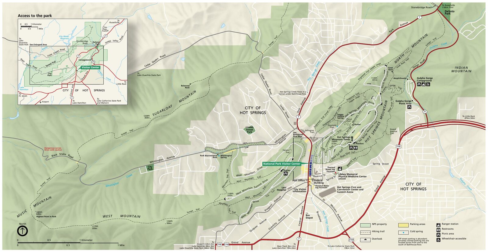
The official park map handed out at entrance stations, with roads, areas, visitor centers and services. View it here or download it for offline use.
Download the map (PDF) Public domain · National Park ServiceWhere Is Hot Springs?
Hot Springs National Park is in Arkansas, in the southern United States, about 56 miles west of Little Rock, the state capital. The city of Hot Springs, with about 38,000 residents, is its true gateway community. NPS-protected thermal springs emerge between hotels, restaurants, and shops along Central Avenue.
Geographically, the park lies in the Ouachita Mountains, a range of low hills covered in mixed pine and oak forests. On a map of the United States, Hot Springs sits roughly halfway between Memphis, Tennessee, about 267 miles east, and Dallas, Texas, about 311 miles southwest. The park fits naturally into a road trip through the Deep South or the Ozarks.
For a complete overview of the region and its place on major Southern itineraries, see our Regions section.
Download the Official Hot Springs Map (NPS Unigrid)
The Unigrid map is the reference document published by the National Park Service. It shows the park boundary, which always comes as a surprise at first glance. Protected areas sit between ordinary streets, parking lots, and businesses. It also shows internal roads, marked trails, and the main facilities.
You can download it free as a PDF at nps.gov/hosp under “Maps.” It's a double-sided foldout. If you print it, be sure your printer's two-sided settings are correct.
A paper copy is also available at the Fordyce Bathhouse Visitor Center on Central Avenue. This is our recommended starting point for any visit.
The Areas of Hot Springs
The park has two very different types of areas: the urban thermal corridor and the surrounding wooded hills.
Bathhouse Row and the Thermal Corridor
This is the historic and thermal heart of the park. Central Avenue is lined with eight bathhouses dating from the early 20th century, including Fordyce, which houses the NPS visitor center and is free to enter, and Buckstaff, the only one still operating in its original role. Behind these facades, 47 thermal springs emerge at about 142°F. Free public fountains along Central Avenue let you taste the cooled thermal water. The Grand Promenade, an elevated half-mile pedestrian walkway, follows the springs along the hillside and looks down over the bathhouses.
Hot Springs Mountain
This is the most accessible and most visited hill. Hot Springs Mountain Road climbs up from town and is open to cars from 8 a.m. to 10 p.m. At the top, the observation tower stands 157 feet high and offers 360-degree views of the city, Lake Hamilton, and the Ouachita Mountains. Walking up from the bottom takes about 45 minutes on the trails.
North Mountain and West Mountain
These two wooded hills offer less crowded trails and a few overlooks of the city. West Mountain Summit Road takes you to the top of West Mountain by car, during the same hours as Hot Springs Mountain Road. You'll mostly see locals out on the trails.
Sugarloaf Mountain and Music Mountain
These two formations to the south make up the wildest part of the park. There's no drivable road to the summits, so you can reach them only on foot. If you're looking for peace and views without the crowds, this is the place.
Park Entrances and Driving Through the Park
Hot Springs has no paid entrance station. You enter the park the same way you enter any city: via Central Avenue, US 7, which runs through Bathhouse Row. There's no entrance fee for the thermal district.
To reach the summits by car, three internal roads are available: Hot Springs Mountain Road, North Mountain Road, and West Mountain Summit Road. They're open to vehicles daily from 8 a.m. to 10 p.m. Pedestrian areas, including the Grand Promenade and Bathhouse Row sidewalks, are accessible from 5 a.m. to 10 p.m.
From Little Rock, the classic route is I-30 west, exit 111 toward US 70 west to Hot Springs, then Spring Street and Central Avenue north. The park appears on your right after Reserve Street.
Map Highlights and Viewpoints
Here are the landmarks to find on your Unigrid map:
- Fordyce Bathhouse Visitor Center: the logical starting point, with free maps and exhibits about the site's thermal history.
- Hot Springs Mountain observation tower: the best overall panorama, accessible by car or on foot via the trail from town.
- Grand Promenade: about 0.6 miles of pedestrian walkway between the springs and the hill, ideal for getting a feel for the park's geography in 15 minutes.
- Drinking fountains: two free public fountains on Central Avenue.
- Gulley Park Trail: a quiet trailhead off Whittington Avenue that climbs toward North Mountain.
For trails with elevation gain and complete routes, our Hot Springs hikes guide breaks down each hike with distances and elevation gain.
Nearest Towns and Airports
The city of Hot Springs is the true gateway community. All services, including restaurants, hotels, grocery stores, and gas stations, are a few minutes from Bathhouse Row by foot or car. For lodging organized by neighborhood and budget, our Hot Springs lodging guide lists the options.
The closest airport is Bill and Hillary Clinton National Airport (LIT) in Little Rock, about 56 miles away, or a 1- to 1.25-hour drive depending on traffic. It serves major U.S. hubs including Dallas, Atlanta, Charlotte, and Chicago. For transportation options from the airport and distances from other cities, our guide to getting to Hot Springs has the details.
Printed Hiking Maps and Trail Guides
If you prefer a durable paper map in the field, National Geographic publishes a Trails Illustrated map covering the Ouachita Mountains around Hot Springs. It's waterproof and tear-resistant, so it holds up to damp forest conditions after a shower.
Falcon publishes a hiking guide dedicated to the park, with trail-by-trail map sketches. You can find it at the Fordyce Visitor Center store or order it online.
For a half-day or full-day visit, the NPS Unigrid map is all you need. The park covers a modest area, and the map is quick to read.
Frequently Asked Questions
Where is Hot Springs National Park on a map of the United States?
Hot Springs National Park is in Arkansas, in the southern United States, about 56 miles west of Little Rock.
Is there an official Hot Springs map I can download?
Yes. The official NPS Unigrid map is available as a free PDF at nps.gov/hosp. Paper copies are also handed out at the Fordyce Bathhouse Visitor Center.
Can you drive through Hot Springs?
Yes. Central Avenue, US 7, runs through Bathhouse Row and serves as the park's main thoroughfare. The roads to the summits, including Hot Springs Mountain, North Mountain, and West Mountain, are open to cars from 8 a.m. to 10 p.m.
What is the closest town to Hot Springs National Park?
The city of Hot Springs, Arkansas, is the true gateway community. The park and the city are woven together.
What's the best viewpoint in the park?
The Hot Springs Mountain observation tower offers 360-degree views of the city, Lake Hamilton, and the Ouachita Mountains. For a complete list of activities, see things to do in Hot Springs.
How long does it take to visit Hot Springs? A half day is enough for Bathhouse Row and the Grand Promenade. A full day lets you add the summits and a few trails. For detailed time recommendations based on your type of visit, our Itinerary & Duration page can help.