
Grand Canyon Map: Layout, Areas, and the Official Downloadable Map
Grand Canyon stretches across northern Arizona, carved by the Colorado River to a depth of more than 5,900 feet. Two rims define the park: the South Rim (open year-round) and the North Rim (open from mid-May to mid-October). The free official NPS map is available as a PDF at nps.gov/grca under “Maps.” Our complete Grand Canyon guide gives you an overview of the park before you dive into the geography here.
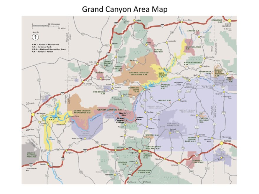
The official park map handed out at entrance stations, with roads, areas, visitor centers and services. View it here or download it for offline use.
Download the map (PDF) Public domain · National Park ServiceWhere Is Grand Canyon?
Grand Canyon National Park is in northern Arizona, about 60 miles north of Williams (Route 64 from Interstate 40) and 80 miles northwest of Flagstaff (Route 180). It lies within the Colorado Plateau, the high desert plateau covering the southwestern corner of the United States.
As the crow flies, the park is about 250 miles east of Las Vegas and 217 miles north of Phoenix. To place the park in the context of the American Southwest, our Regions section covers the geography of the Colorado Plateau and nearby parks you can reach on a road trip.
Download the Official Grand Canyon Map (NPS Unigrid)
The NPS publishes a free Unigrid map of Grand Canyon. It covers both rims, the internal roads, the main trails, and the viewpoints. You can download it as a PDF at nps.gov/grca/planyourvisit/maps.htm.
Download it before you leave. Cell service inside the park is spotty, and in the Inner Canyon it is practically nonexistent. A paper map in your pocket is tangible and will not crash halfway along a trail.
The Areas of Grand Canyon
The park is organized around four distinct geographic areas, each with its own character and access limitations.
The South Rim
This is the busiest rim, open 365 days a year. It has most of the infrastructure: Grand Canyon Village, most South Rim lodging, the free shuttle network, and nearly all the viewpoints you can reach without a hike. Elevation is around 6,900 feet, which keeps temperatures manageable even in summer, at least on the rim.
The North Rim
Perched at about 8,400 feet, the North Rim is cooler, more forested, and significantly less crowded. It generally opens in mid-May and closes in mid-October, depending on snowfall. From the South Rim, the drive is about 210 miles (four hours), because the two rims are not connected by an internal park road. The atmosphere is completely different: fewer people, fir forests, and a view of the canyon that shifts slightly northward.
The Inner Canyon
The canyon floor, where the Colorado River runs at about 2,500 feet, is a world of its own. Keep in mind that temperatures in the Inner Canyon regularly run 18 to 27°F higher than on the rims. Hiking down to the Colorado River and back usually takes a full day, and the climb out is always tougher than you expect. The Bright Angel Trail and South Kaibab Trail start from the South Rim. Our Grand Canyon hiking guide breaks down the options by difficulty and hiking time.
Desert View and the East Side of the Park
At the eastern end of Desert View Drive, the Desert View area is often the first glimpse of the canyon for visitors arriving via Route 64. The Desert View Watchtower offers views of the Colorado River and the wall’s multicolored geological layers. This is also where you’ll find the park’s east entrance.
Park Entrances and Driving
Grand Canyon has three main entrances.
South Entrance (near Tusayan): the busiest entrance. Lines are possible between 9:30 a.m. and 4 p.m., sometimes lasting up to two hours in peak season. Credit cards and the America the Beautiful pass are accepted; cash is not.
Desert View Entrance: open 24/7. From US 89, turn west at Cameron, Arizona, onto State Route 64, then drive 25 miles to the entrance. Your first spectacular view of the canyon begins as soon as you arrive.
North Rim: accessible via Highway 67 from US 89A, only from mid-May through mid-October.
One useful reminder: you cannot drive from the South Rim to the North Rim on an internal park road. You have to go around the outside, a trip of about 210 miles and four hours. On the South Rim, Desert View Drive follows the east rim for 25 miles between Grand Canyon Village and Desert View.
Points of Interest and Viewpoints on the Map
Viewpoints stretch along both rims. On the South Rim, Mather Point is often your first encounter with the drop-off, just a few minutes’ walk from the Visitor Center. Yavapai Point offers an east-facing panorama, with geological panels built into the structure. Farther along the east rim, Lipan Point gives you a rare angle on the Colorado River’s bend. On the North Rim, Bright Angel Point projects out over the canyon.
For an annotated selection of viewpoints organized by hiking time and visitor profile, see our Grand Canyon activities guide.
Nearest Towns and Airports
Williams (about 60 miles south) is the traditional stop along Route 66/I-40, with affordable hotels. Flagstaff (about 80 miles southeast) offers more services, an Amtrak station, and a regional airport, Flagstaff Pulliam Airport.
For international flights, two hubs serve the region: Phoenix Sky Harbor (about 224 miles away, a 3.5-hour drive) and Las Vegas Harry Reid International (about 267 miles away, a four-hour drive). Most road trips start from one or the other. To plan your arrival from these airports and choose how to get to the park, our guide to reaching Grand Canyon covers the options in detail.
Hiking Maps and Paper Topo Guides
The NPS Unigrid map is more than enough for the viewpoints and main trails on the South Rim. For a descent into the Inner Canyon or a rim-to-rim crossing, a dedicated topographic map is recommended. National Geographic Trails Illustrated No. 207 covers the entire park. You can find it at the park’s visitor centers, at a specialty bookstore before you leave, or on online map retailers such as itm.ca.
Frequently Asked Questions
How long do you need to visit Grand Canyon?
The time you need to visit Grand Canyon depends on your itinerary. One day is enough for the South Rim viewpoints, but two to three days let you explore the Inner Canyon or the North Rim as well. Our Grand Canyon itinerary guide offers plans based on your schedule and fitness level.
Which part of Grand Canyon is the most beautiful?
The “most beautiful part” of Grand Canyon depends on what you’re looking for: the South Rim for accessibility and its concentration of viewpoints, the North Rim for peace and elevation, and the Inner Canyon for total immersion in the geology. Our Things to Do page compares the experiences by visitor profile.
What is the closest town to Grand Canyon?
The closest town to Grand Canyon (South Rim) is Williams, about 60 miles south on Interstate 40. Flagstaff, 80 miles away, is the best-served city in the region, with more lodging and a train station.
When is the best time to visit Grand Canyon?
The best times to visit Grand Canyon are spring (April and May) and fall (September and October), when temperatures are moderate on the rims and in the Inner Canyon and crowds are lighter than in summer. Our guide to when to visit details conditions month by month.