

Dry Tortugas Map: Layout, Areas, and Official Map Download
Dry Tortugas National Park lies in the Gulf of Mexico, about 70 miles west of Key West, Florida. It's one of the most remote parks in the national park system: no roads, no bridges, and access only by sea or air. The official NPS map, a free Unigrid PDF, is available on the National Park Service website.
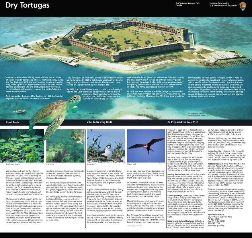
The official park map handed out at entrance stations, with roads, areas, visitor centers and services. View it here or download it for offline use.
Download the map (PDF) Public domain · National Park ServiceWhere Is Dry Tortugas?
Dry Tortugas sits at the southwestern tip of Florida, in the Gulf of Mexico. On a map of the United States, find the tip of the Florida peninsula, head west past the Florida Keys, and continue another 70 miles offshore. You're there.
The park covers an archipelago of seven small coral islands surrounded by shallow water and reefs. Its subtropical climate, ranging from 59°F in winter to 90°F in summer, and its marine wildlife are more reminiscent of the Caribbean than mainland Florida.
To choose when to visit, check the Dry Tortugas weather guide.
Downloading the Official Dry Tortugas Map (NPS Unigrid)
The National Park Service publishes a free Unigrid map of Dry Tortugas as a PDF on nps.gov/drto, in the “Maps” section. It covers the entire archipelago: all seven islands, the boundaries of the marine park, strict-protection areas, and the main points of interest.
This is the reference document to download before any visit. If you're arriving by private boat, print it in a large format. The resolution supports it, and navigating the archipelago's shallow waters requires a precise reading of the seafloor.
Dry Tortugas Areas
The archipelago has seven islands, each with a distinct function on the map.
Garden Key: The Heart of the Visit
Garden Key is where most human activity is concentrated. Fort Jefferson, a massive brick hexagonal fortress built in the 19th century, occupies nearly the entire island. You'll also find the ferry and seaplane dock, the campground, and the ranger station. For the vast majority of visitors, this is the only island they set foot on.
Loggerhead Key: The Offshore Lighthouse
About 2.5 miles west of Garden Key, Loggerhead Key is the largest island in the archipelago. Its lighthouse, built in 1858 and still active, stands out immediately on the map. The island is home to a biological research station. Access is by private boat only, with no services or camping.
Bush Key and the Outlying Islets
Bush Key lies next to Garden Key to the northeast, but it closes every spring to protect the colonies of brown noddies and magnificent frigatebirds that nest there. Long Key, East Key, Middle Key, and Hospital Key are small, hard-to-reach islets visited mostly by birds and private-boat divers.
Getting to the Park: No Cars, No Roads
The map makes it clear right away: there are no roads, no bridges, and no land access. To reach Dry Tortugas from Key West by ferry, seaplane, or private boat, and to find schedules, fares, and reservations, see the guide to getting to Dry Tortugas.
Points of Interest to Find on the Map
A few landmarks to locate before you board.
Fort Jefferson (Garden Key) is a must-see. A visitor trail circles the outer ramparts. Allow an hour to walk the entire loop.
Snorkeling areas: The NPS map marks the coral reef areas accessible by swimming from the Garden Key dock. It's one of Florida's best-preserved snorkeling spots.
Strict-protection areas: Fishing and anchoring are prohibited across much of the park's waters. The map clearly marks these areas, and violating the restrictions can result in a fine.
To plan your visit, see things to do in Dry Tortugas and the hikes on Garden Key in the dedicated guides.
Nearest Cities
Key West is the only realistic departure point for Dry Tortugas, about 70 miles east of the archipelago. Miami, about 162 miles north, is the region's main international gateway.
Hiking Maps and Paper Map Guides
Dry Tortugas is primarily a marine park. There are no topographic hiking maps in the usual sense. The islands are small and flat, with no terrain to follow.
Navigators and divers do need accurate nautical charts, however. NOAA Chart No. 11438 covers the waters around Dry Tortugas and the Tortugas harbor. It's available from specialty nautical chart dealers. For GPS navigation, Navionics and C-MAP vector charts include bathymetric data for the area.
Frequently Asked Questions
Where is Dry Tortugas on a map of the United States?
Dry Tortugas is in the Gulf of Mexico, about 70 miles west of Key West, Florida. On a map of the United States, it's one of the country's southernmost points, within reach of Cuba.
Is there an official Dry Tortugas map, and can I download it?
Yes. The NPS publishes a free Unigrid PDF map on nps.gov/drto. It covers the entire archipelago, protected marine areas, and the main points of interest.
Can you drive through Dry Tortugas?
No. No road or bridge connects the park to the mainland. Access is by ferry from Key West, seaplane, or private boat only.
What is the best place to visit in Dry Tortugas?
The best place depends on what you're looking for. Fort Jefferson on Garden Key is the central site on any visit. The reefs around Garden Key offer excellent snorkeling. The park's Things to Do guide covers all the activity options.
How long does it take to visit Dry Tortugas?
Most visitors make the round trip in a day on the ferry. A few nights of camping let you enjoy the park after the ferry crowds have left. The Dry Tortugas itinerary guide helps you plan.
What is the nearest city to Dry Tortugas?
Key West is the nearest city, about 70 miles east. It's the only departure point for the ferry and seaplane to the park.