
Gateway Arch Map: Layout, Areas, and Official Map Download
Gateway Arch rises in the heart of St. Louis, Missouri, on the west bank of the Mississippi River. The Arch reaches 630 feet and is the national park in its entirety. There are no forest trails or remote sections here, just an extraordinary urban monument surrounded by lawns and an underground museum. To place the park at a glance, you're at the boundary between the Midwest and the Great West, where the Mississippi River separates Missouri from Illinois. The official NPS map (Unigrid PDF) is available as a free download at nps.gov. Our complete Gateway Arch guide gives you the full visit context.
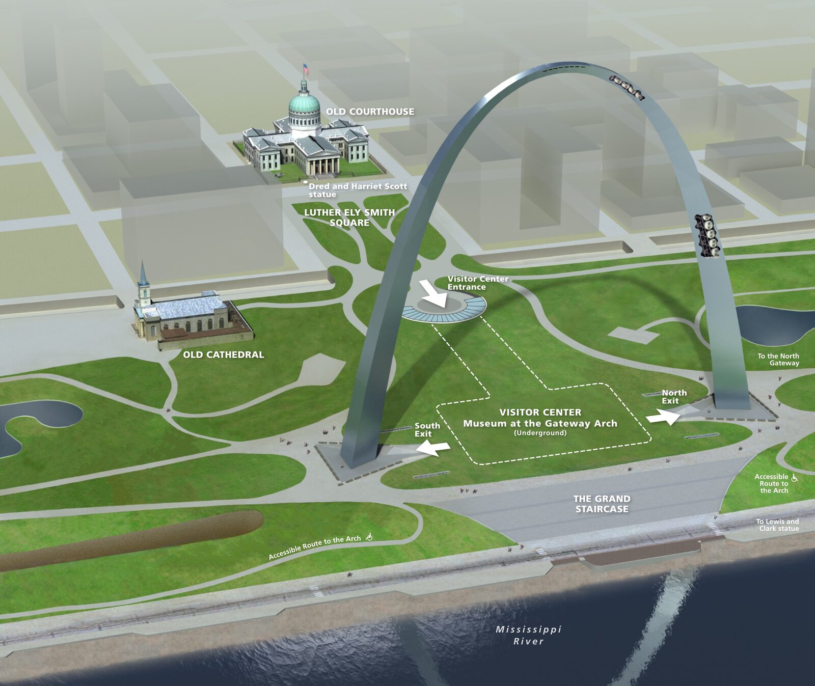
The official park map handed out at entrance stations, with roads, areas, visitor centers and services. View it here or download it for offline use.
Download the map (PDF) Public domain · National Park ServiceWhere Is Gateway Arch?
Gateway Arch National Park occupies St. Louis's historic riverfront in the state of Missouri. The Mississippi River flows just a few yards to the east, with Illinois on the opposite bank. On a map of the United States, St. Louis sits about 292 miles south of Chicago, 193 miles east of Kansas City, and halfway between the Great Lakes and the Gulf of Mexico. This pivotal location is exactly why the city served as the "Gateway to the West" in the 19th century, as the starting point for pioneer caravans crossing the river. To place the monument in its regional setting, our Midwest Region page offers the big picture.
Download the Official Gateway Arch Map (NPS Unigrid)
The National Park Service publishes a free Unigrid map as a PDF on nps.gov and hands it out at the Visitor Center. It shows:
- the exact boundary of the grounds around the Arch;
- the two tram entrances, at the north and south legs;
- the location of the Old Courthouse, about 1,300 feet northwest on Market Street;
- nearby parking garages and pedestrian routes from downtown.
Here's a practical tip: download it before you leave. Cell service in the underground museum is often poor.
Park Areas Shown on the Map
The park is compact. You can walk across it in about 20 minutes. The official map identifies three main areas.
The Grounds and the Gateway Arch
The lawns around the Arch's two legs are open to everyone, with no ticket required, year-round. The two entrance pavilions, north and south, provide access to the interior tram and the museum. This is the heart of the park and where all visitors meet up.
Museum at the Gateway Arch
Located beneath the grounds between the Arch's two legs, the museum traces three centuries of American expansion toward the Pacific. Admission is included with the $19 ticket, which also covers the tram ride. On the map, look for the labels "North Entrance" and "South Entrance" so you can choose your side based on how busy each entrance is.
The Old Courthouse
St. Louis's old courthouse, a few blocks west, has been part of the park since 2018. Admission is free. It tells, among other stories, the history of the Dred Scott trial. The Unigrid map marks it with its exact address. It's worth a visit if you've got an hour to spare.
Getting to the Park and Parking
Gateway Arch isn't a park you drive through. It's a pedestrian space in the middle of downtown. You can park in one of the city's covered garages, including several on Washington Avenue and Chestnut Street shown on the map. The easiest option is MetroLink, St. Louis's urban light rail system. Get off at Arch-Laclede's Landing station for direct access to the north entrance, without having to worry about Wednesday evening traffic. Our Access & Transportation page covers fares, travel times, and parking options.
Points of Interest to Find on the Map
| Point of interest | Location | Key information |
|---|---|---|
| Top of the Arch | North or south leg, reached by Tram Ride to the Top | View of the Mississippi River from 630 feet; $19 |
| Museum at the Gateway Arch | Between the two legs, beneath the grounds | Included with the tram ticket |
| Old Courthouse | About 1,300 feet northwest, Market Street | Free admission |
| Riverfront | Along the park's east side, on the Mississippi River | River cruise departures |
For a complete itinerary with estimated times, our Gateway Arch activities guide takes it from here.
Nearest Cities and Airports
Gateway Arch is right in downtown St. Louis, so you're already in the city when you arrive. Our Access & Transportation page covers the airports and all your travel options.
Hiking Maps and Paper Trail Guides
Gateway Arch has no nature trails, so a hiking guidebook would be beside the point here. If you combine this stop with a road trip through Missouri or Illinois, AAA road maps for Missouri are still very practical. You can find them at local tourism offices.
Frequently Asked Questions
What exactly is Gateway Arch?
Gateway Arch is the central monument in a U.S. national park managed by the National Park Service in St. Louis, Missouri. The 630-foot stainless steel Arch was designed by architect Eero Saarinen and dedicated in 1967 to symbolize St. Louis's historic role as the starting point for American expansion westward.
What does Gateway Arch symbolize?
Gateway Arch symbolizes the "Gateway to the West." In the 19th century, St. Louis was the threshold pioneers crossed before heading into the Great Plains. The Arch is also the city's modern symbol, appearing on tourism materials throughout Missouri.
How tall is Gateway Arch?
The Arch stands 630 feet tall, exactly the same as its width at the base. It's the world's tallest arch and the tallest monument in St. Louis.
Has an airplane ever flown through the Arch?
Yes. Since its dedication in 1967, several pilots have made unauthorized passes through or beneath the Arch. These stunts are illegal, and the airspace above the monument is subject to permanent restrictions. We'll stick to the tram ride for the view.
Can you go to the top of Gateway Arch?
Yes. A tram built into each leg of the Arch takes you to the observation deck 630 feet up. The $19 ticket includes admission to the underground museum. During peak season, from June through August, book ahead. Tickets are sold on recreation.gov, and morning time slots go first.
How long does it take to visit Gateway Arch?
Plan on 2 to 4 hours for a first visit that includes the tram, the museum, and the Old Courthouse. Our Itinerary & Timing page offers plans based on how much time you have.
What is the closest city to Gateway Arch?
Gateway Arch is right in downtown St. Louis, Missouri, so there's no "nearby city" to reach. The most convenient airport is St. Louis Lambert International Airport (STL), about 12 miles northwest of the park.