
Arches National Park Map: Layout, Areas, and Official Map Download
Arches National Park lies in southeastern Utah, 5 miles north of Moab on US 191. The park covers about 120 square miles on the Colorado Plateau and contains more than 2,000 natural sandstone arches. You can download the official NPS map (a free PDF) directly from the National Park Service website. The entrance station also hands out a paper brochure.
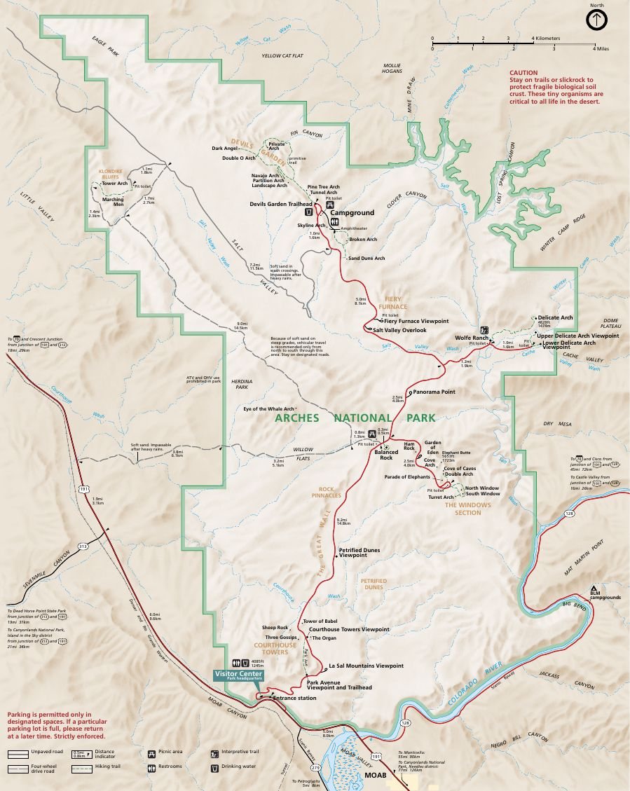
The official park map handed out at entrance stations, with roads, areas, visitor centers and services. View it here or download it for offline use.
Download the map (PDF) Public domain · National Park ServiceWhere Is Arches National Park?
Arches occupies the southeastern corner of Utah, about 230 miles southeast of Salt Lake City. On a map of the United States, the park sits in the Canyonlands region, a landscape of ocher plateaus, mesas, and canyons typical of the Colorado Plateau. Arches is in Utah's Grand County, which handles local administration.
Its proximity to Canyonlands National Park, about 19 miles southwest via US 191 and UT 313, makes it a natural stop on a Utah or Grand Circle road trip. To place Arches in the broader context of the American Southwest, our regional guide provides the big picture.
Download the Official Arches National Park Map
The NPS publishes a Unigrid map as a PDF. One side shows the map with roads, trails, numbered points of interest, and area boundaries. The other side provides practical information about wildlife, regulations, and safety. It's the park's reference document, kept up to date by the NPS.
How to get it: Download it for free from the official park website's Maps page (nps.gov/arch). The entrance station also provides an identical paper brochure at no charge when you pay the entrance fee. Keep it handy because not every secondary trail is marked in the park.
Arches National Park Areas
Your visit centers on one main linear road, Scenic Drive, which climbs for 19 miles from the entrance station to the end of Devils Garden. You pass through the park's areas from south to north. Most parking areas provide access to walks ranging from a few hundred yards to a few miles.
Park Avenue and Courthouse Towers
This is the first area you'll reach after the visitor center. Park Avenue is a corridor of towering sandstone that looks like a miniature skyline from the canyon floor. Courthouse Towers contains several standing formations, including Three Gossips and Sheep Rock. You can view them from the road or from an easy trail along the valley floor. It's an ideal introduction to the park's geology and doesn't require much physical effort.
Balanced Rock and The Windows Section
In the central part of the park, Balanced Rock is a huge boulder perched on a slender pedestal that differential erosion has gradually narrowed. The parking area is right beside the formation, and the loop around the rock takes 20 minutes. Two miles north, The Windows Section includes North Window, South Window, and Turret Arch. You can reach all three on foot in about an hour from the same parking area. Garden of Eden, right next door, offers an unobstructed view of several formations at once.
Delicate Arch and Fiery Furnace
The Delicate Arch trailhead, a 3.1-mile round-trip hike with 480 feet of elevation gain, starts the park's most iconic trail. Bring plenty of water and aim for late afternoon for the best light. Fiery Furnace, a maze of red sandstone fins a little farther north, is accessible only on a ranger-led hike, which requires a reservation, or with an individual permit. For technical details on each trail, our Arches hiking guide covers trails for every ability level.
Devils Garden
At the end of Scenic Drive, 18 miles from the entrance, Devils Garden contains Landscape Arch, the park's longest arch at about 290 feet across, along with Partition Arch, Double O Arch, and several others. Devils Garden Trail has more arches per mile than any other trail in the park.
Park Entrances and Driving Through the Park
Arches has just one entrance: the fee station on US 191, 5 miles north of Moab. There is no northern exit, and Scenic Drive is an out-and-back road. You can't drive straight through the park.
The full out-and-back drive from the entrance to Devils Garden and back covers about 37 miles. The park is open 24 hours a day, year-round. From March through October, visitation is heavy and lines can form at the fee station as early as 8 a.m. Enter before 8 a.m. or after 3 p.m. to avoid them.
Entrance fees: $30 per vehicle, or $15 per pedestrian or cyclist. For annual passes and fee waivers, the National Parks Fees & Passes page explains the basics of entrance fees. During the busy season, a timed entry reservation may be required. Check the conditions at nps.gov/arch before your visit.
Points of Interest and Viewpoints on the Map
The points of interest are numbered on the Unigrid map. Here's where you'll find them in each area:
- Park Avenue Viewpoint: Roadside viewpoint with no walking required, making it a quick photo stop.
- Balanced Rock: 20-minute walking loop with parking right off Scenic Drive.
- The Windows Section: North Window, South Window, Turret Arch, and Garden of Eden, all accessible from the same parking area in about an hour on foot.
- Delicate Arch Viewpoint: Drive-up viewpoint where you can see the arch from a distance without hiking.
- Landscape Arch: 1.2 miles on foot from the Devils Garden parking area. The trail is flat.
To choose the best spots for your available time and your group's fitness level, our What to Do in Arches page offers suggestions for different visit lengths.
Nearest Towns and Airports
Moab, 5 miles south, is the closest town to the park entrance and the natural base for most visitors. For directions from the region's major airports, our guide to getting to Arches covers distances, shuttles, and transportation options.
Hiking Maps and Trail Guides (Print)
The NPS Unigrid map is enough for most visitors. Hikers looking for detailed contour lines can turn to Cartovia Hiking Map No. 211 (Arches National Park, Utah). Specialty travel bookstores also carry trail guides covering the entire Colorado Plateau. These are useful if Arches is part of a larger road trip that includes Canyonlands or Capitol Reef National Park.
Frequently Asked Questions
What should you do in Arches National Park?
Most people explore Arches National Park on foot and by car along Scenic Drive. The highlights include the Delicate Arch trail, Windows Loop, and Devils Garden. Our What to Do in Arches page lists activities by difficulty and length.
How long do you need to visit Arches National Park?
A full day in Arches National Park lets you cover the major sites by car and fit in two or three short trails. To explore Fiery Furnace or Devils Garden in detail, plan on at least two days. Our Itinerary & Length page offers plans for different paces.
When should you visit Arches National Park?
Arches is most pleasant in spring, from April through May, or in fall, from mid-September through October, when daytime temperatures range from 59°F to 81°F. Summer temperatures frequently top 100°F, making long hikes strenuous. Our When to Go page compares the seasons month by month.
What is the closest town to Arches National Park?
Moab is the closest town to Arches National Park, 5 miles south of the entrance on US 191. Moab has nearly all the lodging and services intended for park visitors.
Can you drive through Arches National Park?
No. Arches has only one entrance and exit on US 191. The main road runs 19 miles to Devils Garden and back, with no northern exit. You can't drive all the way through the park.
Is there an official Arches National Park map to download?
Yes. The NPS publishes a free Unigrid PDF map on its official website (nps.gov/arch). The park entrance station also distributes an identical paper brochure for free.